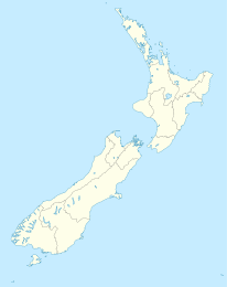
Paerau

Paerau

p1

Paerau
Paerau (Neuseeland)
Paerau
Koordinaten 45° 25′ S, 169° 57′ O-45.418611111111169.94305555556Koordinaten: 45° 25′ S, 169° 57′ O
Region Otago
Distrikt Central-Otago-Distrikt

Paerau (Māori einhundert Bergrücken) ist eine kleine, isoliert gelegene Siedlung im Inland der Region Otago auf der Südinsel Neuseelands. Sie liegt am Oberlauf des Taieri River am Fuße der Rock and Pillar Range. Der Ort liegt in einer Ebene, in der der Fluss Mäander und Altarme bildet. Nordöstlich des Ortes befindet sich ein Stausee.

Der nächstgelegene kleine Ort ist Patearoa, etwa 25 km nordöstlich, der nächste größere Ort Ranfurly, das weitere 20 km nördlich liegt. Der Ort ist nur über eine Hauptstraße mit Patearoa verbunden, Nebenstraßen führen außerdem durch die Lammermoor Range nach Clarks Junction etwa 50 km südlich und den Norden der Lammerlaw Range in das etwa 70 km westlich gelegene Tal des Clutha River um Roxburgh.

In Paerau befindet sich eine kleine Grundschule mit 2009 nur fünf Schülern und einem Decile rating von 10.[1]

"The Styx"

Paerau wird umgangssprachlich auch The Styx genannt. Der Name kommt vom Styx Creek, einem kleinen Nebenfluss des Taieri, der aus dem Great Moss Swamp kommt. "Swamp" ("Sumpf") ist hier irreführend, da das Gebiet für Bewässerungszwecke durch einen Damm überstaut wurde und heute ein See ist. Der Dunstan Trail (heute eine bei trockenem Wetter befahrbare Piste) von Dunedin in die Goldfelder von Central Otago überquert die Rock and Pillar Range von Clarks Junction bei Middlemarch und steigt in das Tal des Oberlaufs des Taieri ab, wo sie den Styx überquert. Die Anspielung an den mythologischen griechischen Styx, den Grenzfluss zur Unterwelt, ist möglicherweise ein Kommentar auf den Charakter der Goldfelder, die damals Pionierland waren. Ursprünglich war Styx Creek nach Clarks Junction die zweite Übernachtung auf dem Weg von Dunedin in die Goldfelder. Hier gibt es ein altes Hotel und Gefängnis. Das Hotel hatte eine Münze in der Bar eingelassen, die auf die Münze verweist, die man benötigte, um den Fährmann für die Überfahrt über den Styx zu bezahlen. Dieses Hotel befindet sich mehrere Kilometer vom "Zentrum" des heutigen Paerau, der Schule, entfernt. Der Dunstan Trail verlief von Paerau in nordwestlicher Richtung über die Serpentine Goldfields zum Poolburn Reservoir und schließlich nach Alexandra.

Weblinks

Quellen

  1. Te Kete Ipurangi, abgerufen 17. Mai 2009

Wikimedia Foundation.

Игры ⚽ Поможем написать курсовую

Schlagen Sie auch in anderen Wörterbüchern nach:

  • Paerau — is a small settlement in inland Otago in New Zealand s South Island. It is located in the upper valley of the Taieri River), at the foot of the Rock and Pillar Range. Its name means one hundred ridges in Maori.Despite being geographically close… …   Wikipedia

  • Styx River, New Zealand — The Styx River is the name of four separate rivers in the South Island of New Zealand.tyx River, West CoastOn the West Coast, the Styx River flows from Styx Saddle into the Kokatahi River. It flows through native bush the majority of its… …   Wikipedia

  • Taieri River — Lage des Flusssystemes des Taieri in Neuseeland DatenVorlage:Infobox Fluss/GKZ fehlt …   Deutsch Wikipedia

  • Great Moss Swamp — Geographische Lage Region Otago, Südinsel (Neuseeland) Abfluss Logan Burn zum …   Deutsch Wikipedia

  • List of reservoirs and dams in New Zealand — Many of the reservoirs and dams in New Zealand have been developed principally to produce hydroelectricity. Hydro electric damsThe main river systems comprising a series of dams and powerhouses are situated on the following rivers:o:The Waikato… …   Wikipedia

  • List of New Zealand place names and their meanings — Placenames in New Zealand derive largely from British and Māori origins. An overview of naming practices can be found at New Zealand place names. * Akaroa Kāi Tahu Māori for Long Harbour . * Albert Town named after Prince Albert of Saxe Coburg… …   Wikipedia

  • Taieri River — The Taieri River is the fourth longest river in New Zealand, and is located in Otago in the country s South Island. Rising in the Lammerlaw ranges, it initially flows north, then east around the Rock and Pillar range before turning southeast,… …   Wikipedia

  • Serpentine (disambiguation) — The word serpentine may refer to:* Serpentine shape, an object or design shaped like the letter S or like a snake * The S shaped riding figure used when training horses. * Serpentine group, a common mineral group * Serpentine belt, a type of… …   Wikipedia

  • Great Moss Swamp — The Great Moss Swamp (also known as the Loganburn Reservoir) is located in Otago, New Zealand, at 45°33 S, 169°56 E. It lies in the Maniototo, close to the former gold mining route of the Old Dunstan Road, 85 kilometres to the northwest of… …   Wikipedia

  • Rock and Pillar Range — The Rock and Pillar Range of high hills is located in the Maniototo, an area of inland Otago, New Zealand. They are surrounded by the Taieri River, which has its source in the range, flowing out across the scroll plain at Paerau, before almost… …   Wikipedia

Share the article and excerpts

Direct link
Do a right-click on the link above
and select “Copy Link”