Petőháza

Petőháza
Petőháza
Wappen von Petőháza
Petőháza (Ungarn)
Paris plan pointer b jms.svg
Basisdaten
Staat: Ungarn
Region: Nyugat-Dunántúl
(Westtransdanubien)
Komitat: Győr-Moson-Sopron
Koordinaten: 47° 36′ N, 16° 54′ O47.59883116.896545Koordinaten: 47° 35′ 56″ N, 16° 53′ 48″ O
Fläche: 2,64 km²
Einwohner: 1.061 (1. Jän. 2010)
Bevölkerungsdichte: 402 Einwohner je km²
Telefonvorwahl: (+36) 099
Postleitzahl: 9443
KSH kódja: 22831
Struktur und Verwaltung
Webpräsenz:

Petőháza (deutsch: Pöttelshausen[1]) ist eine Gemeinde im Kleingebiet Sopron-Fertőd im Komitat Győr-Moson-Sopron in Westungarn.

Am 1. Januar 2010 lebten 1067 Einwohner auf einer Fläche von 2,64 km².

Im Jahr 1879 wurde beim Bau einer Zuckerfabrik in Petőháza der sogenannte Cundpald-Kelch gefunden.[2]

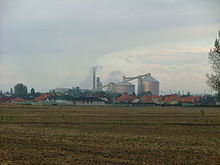
Petőháza ist Standort einer Zuckerfabrik der Firma AGRANA Beteiligungs-AG, eines österreichischen Nahrungsmittel-Konzerns mit Sitz in Wien.

Zuckerfabrik in Petőháza

Persönlichkeiten

Siehe auch

Einzelnachweise

  1. Ortsnamen im Komitat Raab-Wieselburg-Ödenburg-Györ-Moson
  2. Cundpald-Kelch

Wikimedia Foundation.

Игры ⚽ Поможем сделать НИР

Schlagen Sie auch in anderen Wörterbüchern nach:

  • Petőháza — Administration …   Wikipédia en Français

  • Petőháza — Infobox Settlement subdivision type = Country subdivision name = HUN timezone=CET utc offset=+1 timezone DST=CEST utc offset DST=+2|official name=Petőháza subdivision type1=County subdivision name1=Győr Moson Sopron area total km2=2.64 population …   Wikipedia

  • Диллингер, Режё — Режё Диллингер Персональные данные Представляет Венгрия …   Википедия

  • Ikva — Ikwa (veraltet: Eicha), Oberlauf: Aubach, Tauscherbach, Zeiselbach, SpitalbachVorlage:Infobox Fluss/GKZ fehlt Lage Burgenland (Österreich) und Komitat Györ Moson Sopron (Ungarn) Flusssystem Donau Abfl …   Deutsch Wikipedia

  • Rezső Dillinger — Nation Ungarn  Ungarn Geburtst …   Deutsch Wikipedia

  • Sopron — This article is about the city. For the historical county in the Kingdom of Hungary named Sopron / Ödenburg, see Sopron (county). Sopron Aerial photography of the City Hall and the Main square …   Wikipedia

  • Győr-Moson-Sopron County — Infobox Hungarian county name =Győr Moson Sopron region =Western Transdanubia seat = Győr area = 4089 population = 420,000 density = 103 cities = 174Győr Moson Sopron is the name of an administrative county (comitatus or megye) in north western… …   Wikipedia

  • Mosonmagyaróvár — Wieselburg Ungarisch Altenburg Castle …   Wikipedia

  • Maximilian von Götzen-Itúrbide — Maximilian von Götzen Iturbide Pretender Born March 2, 1944 (1944 03 02) (age 67) Beszterc …   Wikipedia

  • Csorna — Aerial view …   Wikipedia

Share the article and excerpts

Direct link
Do a right-click on the link above
and select “Copy Link”