- River Lune
-
Lune 
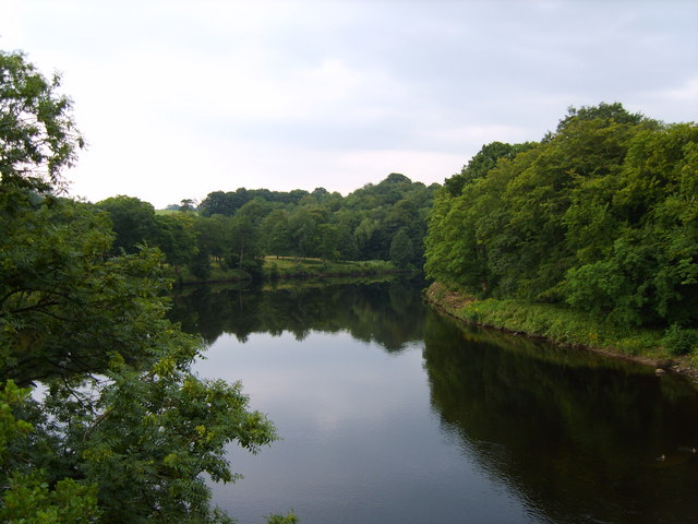
River Lune am Crook o' Lune
Daten Lage Cumbria, Lancashire Flusssystem River Lune Flussgebietseinheit North West Zusammenfluss Sandwath Beck und Weasedale Beck
54° 26′ 28″ N, 2° 29′ 53″ W54.441063-2.497945Mündung bei Plover Scar 53.97947-2.87893Koordinaten: 53° 58′ 46″ N, 2° 52′ 44″ W
53° 58′ 46″ N, 2° 52′ 44″ W53.97947-2.87893Länge 71 km Mittelstädte Lancaster Gemeinden Tebay Häfen Glasson Dock
Der River Lune im Nordwesten Englands entsteht aus dem Zusammenfluss vom Sandwath Beck und dem Weasedale Beck östlich von Ravenstonedale in Cumbria. Nach 71 km mündet der Fluss in der Nähe von Lancaster in die Morecambe Bay und damit in die Irish Sea.Der Oberlauf des Lune, zwischen seiner Quelle und Tebay, wird Lunesdale genannt. Der Lune geht dann in das Tal der Lune Gorge über, in der sich die Autobahn und die Eisenbahnstrecke West Coast Main Line befinden. Der Abschnitt, an dem sich das Tal ausweitet, ist als Lonsdale bekannt.
Etwa 8 km flussaufwärts der Stadt Lancaster, durch die der Fluss fließt, befindet sich ein Flussabschnitt, der als Crook o' Lune bekannt ist und von J.M.W. Turner gemalt wurde. Der Fluss macht hier erst eine 180 Grad Wendung nach rechts und darauf eine 90 Grad Wendung nach links. Die Form des Flusses gleicht damit einem Schäferstab (engl. crook).
Ab dem Skerten Weir Wehr in Lancaster wird der Fluss von Ebbe und Flut beeinflusst. Trotzdem wurde ein Hafen, der sich wahrscheinlich seit der römischen Zeit in Lancaster befand, zwischen 1750 und 1767 mit dem St. George's Quay und dem New Quay ausgebaut. 1779 wurde der Hafen am Glasson Dock erneut erweitert, da dieser Ort näher an der Irish Sea liegt.
Zuflüsse des River Lune
- Janson Pool (entwässert Glasson Marsh]] nahe Glasson Dock)
- Wood Bridge Pool (entwässert Lades Marsh nahe Sunderland Point)
- Lades Pool (entwässert Lades Marsh, bei Overton, Lancashire)
- Chapel Pool (östlich von Overton)
- River Conder
- Brant Beck (nahe Ashton Hall)
- Colloway Pool (bei Stodday)
- Peggymarsh Pool
- Oxcliffe Pool
- Newton Beck (bei Newton in Lancaster)
- Howgill Brook (beit Beaumont in Lancaster)
- Cote Beck (westlich von Halton-with-Aughton)
- Denny Beck (bei Halton)
- Halton Green Beck
- Monkley Gill Beck
- Escow Beck (am Crook o'Lune)
- Deys Beck
- Artle Beck (bei Caton, Lancashire)
- Foxdale Beck
- Crossgill Beck
- Ragill Beck
- Closegill Beck
- Whitespout Gutter
- Rushbed Gutter
- Udale Beck
- Sweet Beck
- Bellhill Clough
- Oval Syke
- Foxdale Beck
- Highfield Beck
- Bull Beck (nahe Brookhouse, Lancashire)
- Kirk Beck
- Tarn Brook
- Traitor's Gill
- Mears Beck
- Westend Beck
- Barncroft Beck
- Clunter Beck (bei Halton-with-Aughton)
- Claughton Beck
- Farleton Beck
- River Wenning
- River Hindburn
- River Roeburn
- Clapham Beck
- Fell Beck (verschwindet im Gaping Gill und
wird in der Ingleborough Cave zum Clapham Beck)
- Fell Beck (verschwindet im Gaping Gill und
- River Hindburn
- Gressingham Beck (nahe Gressingham)
- High Dam Beck
- Spinks Gill Beck
- Thrush Gill (in Thrush Gill Wood)
- Old Lune
- Bains Beck (nahe Arkholme)
- Newton Beck
- River Greta
- River Doe
- River Twiss
- Kingdale Beck
- Back Gill
- Long Gill
- Kingdale Beck
- Leck Beck
- Sellet Mill Beck
- Barbon Beck
- Aygill
- Hazel Sike
- Barkin Beck
- Aygill
- Ashdale Gill
- Toss Beck
- Luge Gill
- Brow Gill
- Wrestle Gill
- River Rawthey
- River Dee
- Clough River
- Rawthey Gill
- Crosdale Beck
- Chapel Beck
- Bram Rigg Beck
- Calf Beck
- Long Rigg Beck
- Fairmile Beck
- Carlin Gill
- Borrow Beck
- Crookdale Beck
- Roundthwaite Beck
- Birk Beck
- Bretherdale Beck
- Wasdale Beck
- Chapel Beck
- Tebay Gill
- Rais Beck
- Ellergill Beck
- Langdale Beck
- Churngill Beck
- Udale Beck
- Churngill Beck
- Cote Beck
- Bowderdale Beck
- Sandwath Beck
- Greenside Beck
- Dale Gill
- Greenside Beck
- Weasdale Beck
Wikimedia Foundation.