Scarba

Scarba
Scarba
Scarba von Luing aus gesehen
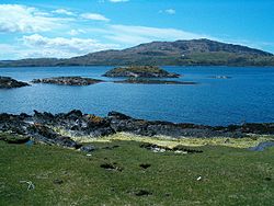
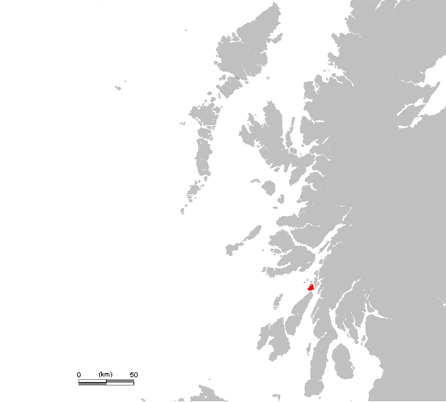
Gewässer Atlantischer Ozean
Inselgruppe Innere Hebriden
Geographische Lage 56° 10′ 35″ N, 5° 42′ 25″ W56.176388888889-5.7069444444444449Koordinaten: 56° 10′ 35″ N, 5° 42′ 25″ W
Lage von Scarba
Länge 5 km
Breite 4 km
Fläche 14,74 km2dep1
Höchste Erhebung Cruach Scarba
449 m
Einwohner (unbewohnt)
Graslandschaft auf Scarba

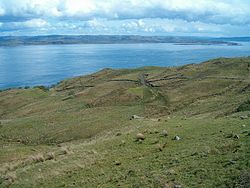
Scarba [ˈs̪kaɾapə] ist eine unbewohnte Insel der Inneren Hebriden. Sie liegt nördlich der Insel Jura und ist von dieser durch die Straße von Corryvreckan getrennt. Die öde Insel erstreckt sich maximal etwa fünf Kilometer in Nord-Süd- und etwa vier Kilometer in Ost-West-Richtung. Der Cruach Scarba ist mit einer Höhe von 449 m die höchste Erhebung der Insel.[1] Es gibt Annahmen, dass die Inseln Scarba, Jura und Islay einst Teil einer großen Halbinsel waren und während den Eiszeiten von der britischen Hauptinsel abgetrennt wurden.[2]

Die Vegetation von Scarba ist durch Gras und Heide bestimmt. Auf der Insel lebt Rotwild sowie wilde Ziegen und Otter. Ferner grasen dort Schafe und Rinder.[1]

Ehemalige Siedlungen lagen im Wesentlichen an der Ostküste der Insel. Kilmory Lodge, das der Eigentümer der Insel zeitweise bewohnt, und ein Anleger in der Bucht Bagh Gleann a' Mhaoil sind die einzigen ständigen Bauwerke.[1]

Einzelnachweise

  1. a b c Eintrag im Gazetteer for Scotland
  2. G. Ritchie (Hrsg.): The Archaeology of Argyll, Edinburgh University Press, Edinburgh, 2. Auflage, 2002, S. 10. ISBN 0-7486-0645-9

Wikimedia Foundation.

Игры ⚽ Поможем решить контрольную работу

Schlagen Sie auch in anderen Wörterbüchern nach:

  • Scarba — Location …   Wikipedia

  • scârbă — SCẤRBĂ, scârbe, s.f. 1. Aversiune nestăpânită (fizică sau morală) faţă de cineva sau de ceva; dezgust, repulsie; greaţă, silă. ♢ loc. vb. A i fi (sau a i se face) cuiva scârbă sau a l prinde (ori a l cuprinde) pe cineva scârba (sau o scârbă) = a… …   Dicționar Român

  • Scarba — Géographie Pays  Royaume Uni Archipel Hébrides intérieures Local …   Wikipédia en Français

  • Scarba — Scarba, Insel aus der südlichen Gruppe der Hebriden, s.d. a) …   Pierer's Universal-Lexikon

  • Scarba — Scarba, schott. Insel in Argyllshire, 2 km nördlich von Jura, 15 qkm groß, mit Wildgehege und (1891) 9 Einw …   Meyers Großes Konversations-Lexikon

  • Scarba —    SCARBA, an island, in the parish of Jura and Colonsay, district of Islay, county of Argyll. This island, which is separated from the northern extremity of the isle of Jura by the gulph of Coryvreckan, is about three miles in length and nearly… …   A Topographical dictionary of Scotland

  • Scarba — Vista desde la Isla de Scarba hacia el norte, donde se pueden ver las islas Slate. Scarba es una pequeña isla ubicada en el concejo de Argyll y Bute, Escocia, al norte de la isla de Jura; ésta es de mayor tamaño que Scarba. La isla no tuvo… …   Wikipedia Español

  • Scarba — Sp Skárba Ap Scarba angliškai Ap Sgarba geliškai (škotiškai) L s. Hebriduose, D. Britanija (Škotija) …   Pasaulio vietovardžiai. Internetinė duomenų bazė

  • Lunga (Scarba) — Pour les articles homonymes, voir Lunga. Lunga Géographie Pays …   Wikipédia en Français

  • Lunga, Firth of Lorn — Infobox Scottish island latitude=56.22 longitude= 5.70 GridReference=NM706086 celtic name=Lunga norse name=Langr oy meaning of name= Old Norse for isle of the longships area=254 ha (628 acres) area rank=96 highest elevation= Bidean na h Iolaire… …   Wikipedia

Share the article and excerpts

Direct link
Do a right-click on the link above
and select “Copy Link”