Sieraków

Sieraków
Sieraków
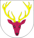
Wappen von Sieraków
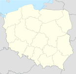
Sieraków (Polen)
Sieraków
Sieraków
Basisdaten
Staat: Polen
Woiwodschaft: Großpolen
Landkreis: Międzychód
Fläche: 14,1 km²
Geographische Lage: 52° 39′ N, 16° 5′ O52.64888888888916.081388888889Koordinaten: 52° 38′ 56″ N, 16° 4′ 53″ O
Höhe: 31 m n.p.m
Einwohner:

6091
(31. Dez. 2010)[1]

Postleitzahl: 64-410
Telefonvorwahl: (+48) 61
Kfz-Kennzeichen: PMI
Gemeinde
Gemeindeart: Stadt- und Landgemeinde
Gemeindegliederung: 28 Ortschaften
15 Schulzenämter
Fläche: 230,3 km²
Einwohner:

8780
(31. Dez. 2010) [2]

Bevölkerungsdichte: 38 Einw./km²
Gemeindenummer (GUS): 3014043
Verwaltung (Stand: 2011)
Bürgermeister: Witold Maciołek
Adresse: ul. 8 Stycznia 38
64-410 Sieraków

Sieraków (deutsch Zirke) ist eine Stadt und Sitz der gleichnamigen Stadt- und Landgemeinde in Polen. Der Ort liegt im Powiat Międzychodzki der Wojewodschaft Großpolen.

Inhaltsverzeichnis

Geschichte

In Zirke befand sich ein staatliches Gestüt. 1919 musste das Königlich Preußische Posen'sche Landgestüt in das "Friedrich-Wilhelm-Gestüt" nach Neustadt (Dosse) evakuiert werden, da die Provinz Posen nach dem Posener Aufstand (1918–1919) zum Großteil an die Zweite Polnische Republik fiel.[3]

Seit 1939 war Zirke wieder Teil des Regierungsbezirkes Posen im 1941 neu gebildeten Landkreis Birnbaum (Wartheland), Reichsgau Wartheland.

Gemeinde

Zur Stadt- und Landgemeinde gehören neben der Stadt Sieraków weitere 15 Ortsteile (deutsche Namen bis 1945)[4][5] mit einem Schulzenamt:

  • Bucharzewo (Bucharzewo, 1943–1945 Schönwald)[5]
  • Chalin (Chalin, 1943–1945 Wilhelmstal)[5]
  • Chorzępowo (Chorzepowo, 1943–1945 Stranddorf)[5]
  • Góra (Gora, 1943–1945 Berghütten)[5]
  • Grobia
  • Izdebno
  • Jabłonowo
  • Kaczlin (Katschlin, 1943–1945 Waldhöfen)[5]
  • Kłosowice (Klosowitz , 1943–1945 Klaswiesen)[5]
  • Lutom (Luttom, 1943–1945 Gerritshof)[5]
  • Lutomek (Lutomek, 1943–1945 Kleinluitom)[5]
  • Ławica (Lawica, 1943–1945 Freiberg)[5]
  • Marianowo (Marianowo, 1943–1945 Marienhof)[5]
  • Przemyśl (Przemyschel, 1943–1945 Mahldorf)[5]
  • Tuchola (Tucholle, 1943–1945 Tuchenau)[5]

Weitere Ortschaften der Gemeinde sind:

  • Błota
  • Borowy Młyn
  • Czapliniec
  • Dębowiec
  • Gospódka
  • Jeleniec
  • Jeziorno
  • Kobylarnia (Kobylarnia, 1943–1945 Hirschdorf)[5]
  • Kukułka
  • Lichwin
  • Pławiska
  • Śrem

Söhne und Töchter der Stadt

  • Hartmut Neugebauer (* 1942), deutscher Schauspieler, Synchronsprecher und Dialogregisseur
  • Krzysztof Opaliński (1609–1655), polnischer Adliger, Beamter im Staatsdienst, Politiker und Dichter

Verweise

Weblinks

 Commons: Sieraków (Wielkopolska) – Sammlung von Bildern, Videos und Audiodateien

Fußnoten

  1. Population. Size and Structure by Territorial Division. As of December 31, 2010. Główny Urząd Statystyczny (GUS), abgerufen am 23. Juni 2011.
  2. Population. Size and Structure by Territorial Division. As of December 31, 2010. Główny Urząd Statystyczny (GUS), abgerufen am 23. Juni 2011.
  3. Vgl. Zeitschrift für Ostforschung, Band 34, J.- G.- Herder-Institut (Hrsg.), 1985, S. 222 und Friedrich Freiherr von Senden: Geschichte der Freiherrn von Senden und Freiherrn Schuler von Senden, ISBN 978-3-86805-376-0, Pro Business, Berlin 2009, S. 227
  4. Das Genealogische Orts-Verzeichnis
  5. a b c d e f g h i j k l m n Vgl. Deutsche Topograph. Karte, 3362 Zirke

Wikimedia Foundation.

Игры ⚽ Поможем написать реферат

Schlagen Sie auch in anderen Wörterbüchern nach:

  • Sieraków — Sierakow Sierakow (Sieraków en polonais, prononcer sié ra couf) est une ville de Pologne. panorama de Sierakow …   Wikipédia en Français

  • Sierakow — (Sieraków en polonais, prononcer sié ra couf) est une ville de Pologne. panorama de Sierakow …   Wikipédia en Français

  • Sierakow — Sierakow, Stadt, so v.w. Zirke …   Pierer's Universal-Lexikon

  • Sieraków — Infobox Settlement name = Sieraków imagesize = 250px image caption = Town view image shield = POL Sieraków COA.svg pushpin pushpin label position = bottom subdivision type = Country subdivision name = POL subdivision type1 = Voivodeship… …   Wikipedia

  • Sierakow — Original name in latin Sierakw Name in other language Gorad Sjarakau, Serakova, Serakuv, Sierakow, Sierakw, xie la ku fu, Горад Сярaкаў, Серакув State code PL Continent/City Europe/Warsaw longitude 52.65134 latitude 16.08047 altitude 42… …   Cities with a population over 1000 database

  • Sieraków (disambiguation) — Sieraków may refer to the following places: *Sieraków in Greater Poland Voivodeship (west central Poland) *Sieraków, Lesser Poland Voivodeship (south Poland) *Sieraków, Łódź Voivodeship (central Poland) *Sieraków, Świętokrzyskie Voivodeship… …   Wikipedia

  • Sieraków Landscape Park — Infobox protected area name=Sieraków Landscape Park native name=Sierakowski Park Krajobrazowy iucn category = V caption= location=Greater Poland Voivodeship area= established=Sieraków Landscape Park ( Sierakowski Park Krajobrazowy ) is a… …   Wikipedia

  • Sieraków, Łódź Voivodeship — Infobox Settlement name = Sieraków settlement type = Village total type = image shield = subdivision type = Country subdivision name = POL subdivision type1 = Voivodeship subdivision name1 = Łódź subdivision type2 = County subdivision name2 =… …   Wikipedia

  • Sieraków, Lesser Poland Voivodeship — Infobox Settlement name = Sieraków settlement type = Village total type = image shield = subdivision type = Country subdivision name = POL subdivision type1 = Voivodeship subdivision name1 = Lesser Poland subdivision type2 = County subdivision… …   Wikipedia

  • Sieraków, Świętokrzyskie Voivodeship — Infobox Settlement name = Sieraków settlement type = Village total type = image shield = subdivision type = Country subdivision name = POL subdivision type1 = Voivodeship subdivision name1 = Świętokrzyskie subdivision type2 = County subdivision… …   Wikipedia

Share the article and excerpts

Direct link
Do a right-click on the link above
and select “Copy Link”