- Silay City
-
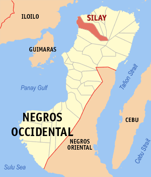
Silay City Lage von Silay City in der Provinz Negros Occidental 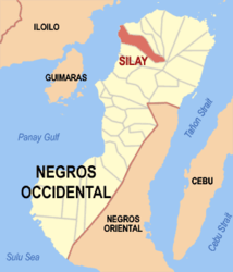
Basisdaten Bezirk: Western Visayas Provinz: Negros Occidental Barangays: 16 Distrikt: 6. Distrikt von Negros Occidental PSGC: 064526000 Einkommensklasse: 2. Einkommensklasse Haushalte: 6699 Zensus 1. Mai 2000Einwohnerzahl: 120.365 Zensus 1. August 2007Bevölkerungsdichte: 120365 / 214,80 Einwohner je km² Fläche: 214.80 km² Koordinaten: 10° 48′ N, 122° 58′ O10.8122.96666666667Koordinaten: 10° 48′ N, 122° 58′ O Postleitzahl: 6116 Bürgermeister: Jose L. Montelibano Offizielle Webpräsenz: [1] Geographische Lage auf den Philippinen 

Silay City Silay City liegt in der Provinz Negros Occidental im Nordosten der Insel Negros. Sie ist eine Stadt der zweiten Einkommensklasse in den Philippinen. Das Wappen der Stadt setzt sich folgendermaßen zusammen: Die sechzehn Sterne symbolisieren die sechzehn Barangays der Stadt. Im Zentrum des Wappens befindet sich eine Zuckermühle und symbolisiert die wichtigste ansässige Industrie, die Zuckerpflanze und der Fisch symbolisieren die wichtigsten Lebensgrundlagen der Bevölkerung von Silay City. Der Kansilay Baum und die Santan Blume sind die offiziellen Pflanzen von Silay City und verweisen auf den Gründungsmythos um die Prinzessin Kansilay. Die Stadt besitzt sogar einen offizielles Stadtlied: das "Martsa Sang Silaynon" Lied.
Inhaltsverzeichnis
Geographie
Die Stadt grenzt im Westen an die Guimaras Straße, die Negros und die Insel Panay trennen. Im Norden grenzt Silay City an das Territorium der Municipality of E.B. Magalona, im Osten begrenzen das Marapara Gebirge mit der mächtigen Erscheinung des Vulkans Silay das Stadtgebiet. Im Süden grenzt Silay City an das Gebiet City of Talisay, diese trennt sie von der 14 km entfernten Provinzhauptstadt von Negros Occidental Bacolod.
Flächennutzung
Die Flächennutzung der Stadt und seines Verwaltungsgebietes wird wiefolgt angegeben Wohnbebauung: 624,5 Hektar Handel: 59,80 Hektar Industrie: 91,70 Hektar Landwirtschaft: 2.838,704 Hektar Waldbestand: 17.865,00 Hektar
Die Grundfläche der Stadt wird mit 214,80 km² angegeben.
Barangays
- Barangay I
- Barangay II
- Barangay III
- Barangay IV
- Barangay V
- Hawaiian
- Bagtic
- Balaring
- E.Lopez
- Guimbala-On
- Guinhalaran
- Kapitan Ramon
- Lantad
- Mambulac
- Patag
- Rizal
Quelle
- Offizielle Homepage von Silay City: http://www.silaycity.gov.ph/
Städte: Bago City | Cadiz City | Escalante City | Kabankalan City | La Carlota City | Himamaylan City | Sagay City | San Carlos City | Silay City | Sipalay City | Talisay City | Victorias City | Bacolod City
Stadtgemeinden: Binalbagan | Calatrava | Candoni | Cauayan | Enrique B. Magalona | Hinigaran | Hinoba-an | Ilog | Isabela | La Castellana | Manapla | Moises Padilla | Murcia | Pontevedra | Pulupandan | Salvador Benedicto | San Enrique | Toboso | Valladolid

Wikimedia Foundation.