- Sonbhadra
-
Distrikt Sonbhadra 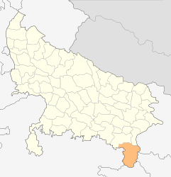
Bundesstaat: Uttar Pradesh Division: Mirzapur Verwaltungssitz: Robertsganj Fläche: 6.788 km² Einwohner: 1.463.519 (2001) Bevölkerungsdichte: 216 Ew./km² Website: sonbhadra.nic.in Der Distrikt Sonbhadra (Hindi: सोनभद्र Sonbhadra [ˈsoːnbʱʌdrʌ]; auch Sonebhadra) ist ein Distrikt des indischen Bundesstaats Uttar Pradesh. Verwaltungszentrum ist die Stadt Robertsganj. Seinen Namen trägt der Distrikt nach dem Fluss Son.
Inhaltsverzeichnis
Geografie
Der Distrikt Sonbhadra liegt im äußersten Südosten Uttar Pradeshs an der Grenze zu den vier Nachbarbundesstaaten Bihar, Jharkhand, Chhattisgarh und Madhya Pradesh. Nachbardistrikte sind Mirzapur im Nordwesten, Chandauli im Norden (beide Uttar Pradesh), Kaimur (Bihar) im Nordosten, Garhwa (Jharkhand) im Osten, Surguja (Chhattisgarh) im Süden sowie Singrauli (Madhya Pradesh) im Westen. Der Distrikt Sonbhadra gehört zur Division Mirzapur und ist in die drei Tehsils Duddhi, Ghorawal und Robertsganj unterteilt.
Mit einer Fläche von 6.788 Quadratkilometern ist Sonbhadra der flächenmäßig zweitgrößte Distrikt Uttar Pradeshs.[1] Während der größte Teil Uttar Pradeshs in der Gangesebene liegt, gehört der Distrikt Sonbhadra bereits zum höhergelegenen Vindhya-Plateau. Der nördliche Teil des Distriktgebiets stellt sich als recht ebenes Plateau dar. Südlich davon verläuft die Kaimur-Bergkette quer durch das Distriktgebiet. Nach Süden hin fallen die Kaimur-Berge abrupt in das tief eingeschnittene Tal des Son-Flusses ab, der von Westen nach Osten durch den Distrikt fließt. Das Gebiet südlich des Son ist hügelig und wird vom Rihand, einem Nebenfluss des Son, durchflossen. Durch einen Staudamm ist der Rihand an der Grenze zu Madhya Pradesh Stausee Govind Ballabh Pant Sagar aufgestaut. Mit 468 Quadratkilometern Fläche ist dieser der größte Stausee Nordindiens.
Während das nördliche Plateau landwirtschaftlich genutzt wird, sind die hügeligen Gebiete beiderseits des Son noch dicht bewaldet. Insgesamt besteht mehr als die Hälfte des Distriktgebiets aus Wäldern.[2]
Geschichte
Sonbhadra besteht seit 1989 als eigenständiger Distrikt. Zuvor war das Gebiet Teil des Distrikts Mirzapur.
Bevölkerung
Zum Zeitpunkt der Volkszählung 2001 hatte Sonbhadra 1.463.519 Einwohner. Aufgrund der geografischen Begebenheiten ist der Distrikt weitaus dünner besiedelt als der Rest Uttar Pradeshs: Mit 216 Einwohnern pro Quadratkilometer ist die Bevölkerungsdichte die zweitniedrigste der Distrikte Uttar Pradeshs und liegt weit unter dem Durchschnitt des Bundesstaats von 690 Einwohnern pro Quadratkilometer. Die Alphabetisierungsquote ist mit 49,2 % sehr niedrig und liegt noch unter dem ohnehin schon niedrigen Mittelwert Uttar Pradeshs (56,3 %).
Im Distrikt Sonbhadra leben gut 130.000 Angehörige des Adivasi-Volks der Gond. Diese werden in Uttar Pradesh in den Bevölkerungsstatistiken allerdings nicht als Stammesvolk (scheduled tribe) sondern als niedere Kaste (scheduled caste) gezählt. Anders als andere Gond-Gruppen haben die Gonds in Sonbhadra ihre eigene Sprache aufgegeben und sprechen die Mehrheitssprache Hindi.
Unter den Einwohnern des Distrikts Sonbhadra stellen Hindus mit 94,0 % die große Mehrheit. Daneben gibt es eine kleine muslimische Minderheit von 5,4 %.[3]
Städte
Stadt Einwohner
(2001)[4]Anpara 22.385 Bijpur 9.232 Chopan 12.131 Churk Ghurma 8.685 Dudhi 11.606 Ghorawal 6.478 Jamshila 10.270 Khariya 9.836 Kota 13.544 Obra 52.398 Parasi 21.203 Pipri 13.213 Renukoot 53.524 Robertsganj 32.209 Einzelnachweise
- ↑ Know India: Districts : Uttar Pradesh
- ↑ Website des Distrikts Sonbhadra: Forest & Environment.
- ↑ Census of India 2001: Basic Data Sheet. District Sonbhadra (70), Uttar Pradesh (09).
- ↑ Census of India 2001: Population, population in the age group 0-6 and literates by sex - Cities/Towns (in alphabetic order)
Weblinks

Agra | Aligarh | Allahabad | Ambedkar Nagar | Auraiya | Azamgarh | Badaun | Baghpat | Bahraich | Ballia | Balrampur | Banda | Barabanki | Bareilly | Basti | Bijnor | Bulandshahr | Chandauli | Chhatrapati Shahuji Maharaj Nagar | Chitrakoot | Deoria | Etah | Etawah | Faizabad | Farrukhabad | Fatehpur | Firozabad | Gautam Buddha Nagar | Ghaziabad | Ghazipur | Gonda | Gorakhpur | Hamirpur | Hardoi | Jalaun | Jaunpur | Jhansi | Jyotiba Phule Nagar | Kannauj | Kanpur Nagar | Kanshi Ram Nagar | Kaushambi | Kushinagar | Lakhimpur Kheri | Lalitpur | Lucknow | Mahamaya Nagar | Maharajganj | Mahoba | Mainpuri | Mathura | Mau | Meerut | Mirzapur | Moradabad | Muzaffarnagar | Pilibhit | Pratapgarh | Raebareli | Rambai Nagar | Rampur | Saharanpur | Sant Kabir Nagar | Sant Ravidas Nagar | Shahjahanpur | Shravasti | Siddharthnagar | Sitapur | Sonbhadra | Sultanpur | Unnao | Varanasi
Wikimedia Foundation.
Schlagen Sie auch in anderen Wörterbüchern nach:
Sonbhadra district — Sonbhadra or Sonebhadra is the largest district of Uttar Pradesh, India. The district has an area of 6788 km² and a population of 1,463,468 (2001 census), with a population density of 216 persons per km². It lies in the extreme southeast of the… … Wikipedia
Mirzapur division — Contents 1 About Mirzapur Mandal 2 Industries 3 Other 4 Towns in Mirzpur Mandal 5 Major Rivers … Wikipedia
Chopan — For the composer, see Frédéric Chopin. Chopan city … Wikipedia
Churk — Ghurma city Coordinates Country India State Uttar Pradesh … Wikipedia
Dudhi — Duddhi city … Wikipedia
Mayurpur Airport — IATA: none – ICAO: VI1D … Wikipedia
Mirzapur — This article is about the municipality in Uttar Pradesh, India. For its namesake district, see Mirzapur district. Mirzapur city [[file:Mirzapur from the atul skyline caption = Mizrapur from the Ganges|250px|none|alt=|View… … Wikipedia
Mirzapur district — This article is about the district. For its eponymous headquarters, see Mirzapur. Mirzapur district मीरज़ापुर ज़िला مرزا پور ضلع … Wikipedia
List of districts of Uttar Pradesh — Districts of Uttar Pradesh The Indian state of Uttar Pradesh borders with Nepal and the Indian states of Bihar, Jharkhand, Chhattisgarh, Madhya Pradesh, Rajasthan, Haryana, Uttarakhand and National Capital Territory of Delhi. The … Wikipedia
Obra, Uttar Pradesh — Obra city … Wikipedia
Sonbhadra

18+
© Academic, 2000-2026
- Kontaktieren Sie uns: Unterstützung, Werbung
Wörterbücher Export, schritte mit PHP, Joomla, Drupal, WordPress, MODx.