Vecumnieki

Vecumnieki
Vecumnieki
Wappen fehlt
Hilfe zu Wappen
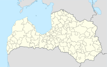
Vecumnieki (Lettland)
Red pog.svg
Basisdaten
Staat: Lettland
Landschaft: Semgallen (lettisch: Zemgale)
Verwaltungsbezirk: Vecumnieku novads
Koordinaten: 56° 36′ N, 24° 31′ O56.60638888888924.52222222222235Koordinaten: 56° 36′ 23″ N, 24° 31′ 20″ O
Einwohner: 2.487 (1. Jan. 2007)
Fläche:
Bevölkerungsdichte:
Höhe: 35 m NAP
Webseite: www.vecumnieki.lv

Vecumnieki ist eine Ortschaft in Lettland, 45 Km südlich von Riga.

Inhaltsverzeichnis

Geschichte

Hier befand sich der Krebsenkrug. Nachdem 1904 die Bahnstation Neugut an der Strecke Mitau - Kreutzburg eingerichtet wurde, entstand eine Ansiedlung. Bis 1940 hieß die Ortschaft Vecmuiža. 1951 wurde das Gebiet der örtlichen Kolchose "Sarkana zvaigzne" (Roter Stern) eingemeindet. 1954 zwei weitere Orte.

Vecumnieku novads

Seit der Auflösung der Landkreise 2009 bildet Vecumnieki mit 5 umliegenden Gemeinden eine Verwaltungsgemeinschaft. Hier leben 9708 Einwohner (1. Juli 2010).

Literatur

Einzelnachweise


Wikimedia Foundation.

Игры ⚽ Поможем решить контрольную работу

Schlagen Sie auch in anderen Wörterbüchern nach:

  • Vecumnieki — is a town in Bauska District, Latvia, with a population of 2500. It is just north of the Jelgava Jekabpils railroad.There are few shops, kindergarten and a secondary school.Parish of Vecumnieki is one of 10 largest parishes in Latvia, with… …   Wikipedia

  • Vecumnieki — Original name in latin Vecumnieki Name in other language Vecmuiza, Vecmuia, Vecumnieki, Vetsmuizha, Vetsumneki, Vetsumniyeki, Вецумниеки State code LV Continent/City Europe/Riga longitude 56.60639 latitude 24.52222 altitude 35 Population 2487… …   Cities with a population over 1000 database

  • Vecumnieki — Sp Vẽcumniekai Ap Vecumnieki L Latvija …   Pasaulio vietovardžiai. Internetinė duomenų bazė

  • Municipalidad de Vecumnieki — Municipalidad de Vecumnieku Vecumnieku novads Municipalidad de Letonia …   Wikipedia Español

  • Administrative divisions of Latvia — Administrative divisions of Latvia, (valid 1 July 2009). According to the Administrative territorial reform of Latvia, Latvia changed its administrative divisions from two level municipalities (towns, cities, towns countryside territories and… …   Wikipedia

  • Daugavpils — Dinaburg redirects here. For the football team, see Dinaburg FC. Daugavpils   City   A view of Daugavpils in 1912 …   Wikipedia

  • List of National Roads in Latvia — P116 redirects here. For the New Testament manuscript P.Vindob.G 42417, see Papyrus 116. This is a list of National Roads in Latvia: Contents 1 State Main Roads 2 State 1st Class Roads 3 State 2nd Class Roads …   Wikipedia

  • Jelgava —   City   Jelgava Aerial View …   Wikipedia

  • Bauska District — Latvian districts| 2= 3=51,974 4=1,880 5=27.65 6= [http://www.bauskarp.lv/ bauskarp.lv/] The Bauska District ( lv. Bauskas rajons) is an administrative division of Latvia, located in the Semigallia region, in the country s centre. It is organized …   Wikipedia

  • Verwaltungsgliederung Lettlands — Die Verwaltungsgliederung Lettlands umfasst neun Republik Städte (lettisch republikas pilsētas) und 110 Bezirke (novadi).[1] Inhaltsverzeichnis …   Deutsch Wikipedia

Share the article and excerpts

Direct link
Do a right-click on the link above
and select “Copy Link”