Virudhunagar

Virudhunagar
Virudhunagar
விருதுநகர்
Virudhunagar (Indien)
Red pog.svg
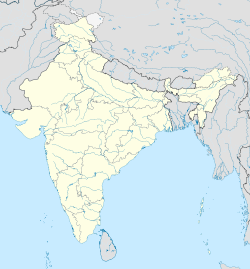
Staat: Indien
Bundesstaat: Tamil Nadu
Distrikt: Virudhunagar
Lage: 9° 35′ N, 77° 57′ O9.583333333333377.95Koordinaten: 9° 35′ N, 77° 57′ O
Einwohner: 73.003 (2001)

d1

Virudhunagar (Tamil: விருதுநகர் Virutunagar [ˈʋiɾɯðɯnaɡəɾ], auch Virudunagar, früher Virudupatti) ist eine Stadt im südindischen Bundesstaat Tamil Nadu. Sie liegt im südlichen Binnenland des Bundesstaates 45 Kilometer südlich von Madurai. Zum Zeitpunkt der indischen Volkszählung von 2001 hatte Virudhunagar 73.003 Einwohner.[1] Die Stadt ist Verwaltungssitz des Distrikts Virudhunagar.

Virudhunagar ist ein wichtiges Handelszentrum, in dem Waren des ländlichen Umlands wie Öl, Baumwolle, Chili, Gewürze und Kardamom umgeschlagen werden. Die Stadt liegt verkehrsgünstig am National Highway 7, der als längste Fernstraße Indiens Varanasi mit Kanyakumari verbindet. Ferner ist der Bahnhof von Virudhunagar ein wichtiger Verkehrsknotenpunkt: Hier zweigt von der Hauptstrecke von Madurai nach Tirunelveli eine Nebenstrecke ab, die über Tenkasi an die Westküste nach Kollam führt.

Virudhunagar ist der Geburtsort von K. Kamaraj (1903–1975), dem früheren Präsidenten der Kongresspartei und späteren Chief Minister von Tamil Nadu. Hauptsehenswürdigkeiten der Stadt sind das Geburtshaus Kamarajs und ein 400 Jahre alter Tempel der Göttin Mariamman.

Einzelnachweise

  1. Census of India 2001: Population, population in the age group 0-6 and literates by sex - Cities/Towns (in alphabetic order)

Weblinks


Wikimedia Foundation.

Игры ⚽ Поможем написать реферат

Schlagen Sie auch in anderen Wörterbüchern nach:

  • Virudhunagar — Localidad de la India …   Wikipedia Español

  • Virudhunagar — Infobox Indian Jurisdiction native name = Virudhunagar | type = city | latd = 9.583| longd = 77.958 state name = Tamil Nadu district = Virudhunagar leader title = leader name = altitude = population as of = 2001 population total = 73,003|… …   Wikipedia

  • Virudhunagar — Admin ASC 2 Code Orig. name Virudhunagar Country and Admin Code IN.25.7646157 IN …   World countries Adminstrative division ASC I-II

  • Virudhunagar district — is an administrative district of Tamil Nadu state in southern India. Virudhunagar is the district headquarters. It had a population of 1,751,301 as of 2001. It is 44.39% urbanised. [http://www.censusindiamaps.net/page/India WhizMap/IndiaMap.htm]… …   Wikipedia

  • Virudhunagar (Distrikt) — Distrikt Virudhunagar விருதுநகர் மாவட்டம் Bundesstaat: Tamil Nadu Verwaltungssitz …   Deutsch Wikipedia

  • Alangulam (Virudhunagar district) — Infobox Indian Jurisdiction native name = Alangulam | type = city | latd = 9.94 | longd = 77.57 locator position = right | state name = Tamil Nadu district = Virudhunagar leader title = leader name = altitude = 127 population as of = 2001… …   Wikipedia

  • Anaiyur (Virudhunagar district) — Infobox Indian Jurisdiction native name = Anaiyur | type = city | latd = | longd = state name = Tamil Nadu district = Virudhunagar leader title = leader name = altitude = population as of = 2001 population total = 19,847| population density =… …   Wikipedia

  • Pallapatti, Virudhunagar — Infobox Indian Jurisdiction native name = Pallapatti | type = city | latd = | longd = state name = Tamil Nadu district = Virudhunagar leader title = leader name = altitude = population as of = 2001 population total = 24,319| population density =… …   Wikipedia

  • Pudupatti, Virudhunagar — Infobox Indian Jurisdiction native name = Pudupatti | type = city | latd = | longd = state name = Tamil Nadu district = Virudhunagar leader title = leader name = altitude = population as of = 2001 population total = 7846| population density =… …   Wikipedia

  • Aruppukkottai — Aruppukottai   town   …   Wikipedia

Share the article and excerpts

Direct link
Do a right-click on the link above
and select “Copy Link”