Chuginadak Island

Chuginadak Island
Chuginadak Island
Mount Cleveland auf Chuginadak Island
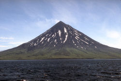
Gewässer Pazifischer Ozean
Inselgruppe Islands of Four Mountains (Alëuten)
Geographische Lage 52° 51′ N, 169° 49′ W52.844722-169.8180561730Koordinaten: 52° 51′ N, 169° 49′ W
Chuginadak Island (Alaska)
Chuginadak Island
Länge 23 km
Fläche 167 km²
Höchste Erhebung Mount Cleveland
1.730 m
Einwohner (unbewohnt)

Chuginadak Island (aleutisch: Tanax̂ Angunax̂) ist die zweitgrößte Insel der Islands of Four Mountains, einem Teil des alëutischen Archipels. Chuginadak ist ein alëutischer Name, der vom Kapitän Tebenkov 1852 in einer Karte erwähnt wurde. Nach R. H. Geoghegan bedeutet der alëutische Wortstamm „chugi“ so viel wie „zu braten“ oder „zu rösten“. Die westliche Hälfte der Insel wird in Aleut Chuginadax genannt.

Die Insel ist ungefähr 23 km lang. Der aktive Schichtvulkan Mount Cleveland bildet die gesamte westliche Hälfte der Landmasse. Ein schmaler Streifen des Landes trennt den Vulkan von der schroffen und niedereren östlichen Seite der Insel. Der einzige größere geographische Platz ist die 4 km lange Applegate-Bucht (alëutisch: Chuguuĝix̂) an der Nordküste. Die Bucht wurde nach Samuel Applegate vom U.S. Coast and Geodetic Survey benannt, der den Schoner Nellie Juan während einer Erkundung dieses Bereichs in den 1880ern befehligte.

Auf der Insel Chuginadak befindet sich neben dem Mount Cleveland noch der Schichtvulkan Mount Tana.

Weblinks


Wikimedia Foundation.

Игры ⚽ Нужно решить контрольную?

Schlagen Sie auch in anderen Wörterbüchern nach:

  • Chuginadak Island — Mount Cleveland erupts in 2006. Taken from the International Space Station Geography Location Aleutian Islands, Alaska, USA Coordinates …   Wikipedia

  • Herbert Island — aus dem All gesehen Höhe 1.288  …   Deutsch Wikipedia

  • Herbert Island — Location map Alaska label= lat=52.91976 long= 171.319171 position=right width=250 float=right caption=Location in AlaskaHerbert Island (Chiĝulax̂ [Bergsland, K Aleut Dictionary Fairbanks: Alaska Native Language Center, 1994] in Aleut) is an… …   Wikipedia

  • Carlisle Island — Vorlage:Infobox Insel/Wartung/Fläche fehlt Carlisle Island Mount Carlisle Gewässer Pazifischer Ozean …   Deutsch Wikipedia

  • Kagamil Island — Kagamil Höhe 893 m …   Deutsch Wikipedia

  • Carlisle Island — Location map Alaska label= lat=53.090719 long= 171.28909 position=right width=250 float=right caption=Location in AlaskaCarlisle Island (Kigalĝa [Bergsland, K Aleut Dictionary Fairbanks: Alaska Native Language Center, 1994] in Aleut) is an island …   Wikipedia

  • Kagamil Island — Location map Alaska label= lat=53.1714 long= 170.9395 position=right width=250 float=right caption=Location in AlaskaKagamil Island (Qagaamila [Bergsland, K Aleut Dictionary Fairbanks: Alaska Native Language Center, 1994] in Aleut), the most… …   Wikipedia

  • Nunivak Island — Nunivak Maskette – Nunivak …   Wikipedia

  • Medny Island — Map showing position of Commander Islands to the east of Kamchatka. The smaller island in the east is Medny and the larger island is Bering Island. Medny Island (also spelled Mednyy, Russian: остров Медный, sometimes called Copper Island in… …   Wikipedia

  • Unalaska Island — Unalaska Native name: Nawan Alaxsxa[1] Map of the island …   Wikipedia

Share the article and excerpts

Direct link
Do a right-click on the link above
and select “Copy Link”