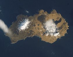
- Yunaska Island
-
Yunaska Island Yunaska Island vom All aus gesehen Gewässer Pazifik Inselgruppe Aleuten Geographische Lage 52° 38′ N, 170° 42′ W52.63138-170.69694950Koordinaten: 52° 38′ N, 170° 42′ W Länge 23 km Breite 5,5 km Fläche 173 km² Höchste Erhebung 950 m Einwohner (unbewohnt) Yunaska Island (aleutisch:Chiĝulax̂) gehört zu den Aleuten, einer Inselkette zwischen Nordamerika und Asien, und ist die größte Insel der Islands of Four Mountains. Auf der 173 km² großen, 23 km langen und ca. 5,5 km breiten Insel gibt es zwei Vulkane, die durch ein Tal getrennt sind. Vom westlichen, einem 950 m hohen Schichtvulkan, ist bis heute noch kein Ausbruch bekannt. Der östliche, ein 500 m hoher Schildvulkan, ist nachweislich das letzte Mal 1937 ausgebrochen.
Weblinks
- Beschreibung der Vulkane (engl.)
- Bilder und Kurzbeschreibung (engl.)
Schlagen Sie auch in anderen Wörterbüchern nach:
Yunaska Island — Location map Alaska label= lat=52.818979 long= 172.234493 position=right width=250 float=right caption=Location in AlaskaYunaska (Yunax̂sxa [Bergsland, K Aleut Dictionary Fairbanks: Alaska Native Language Center, 1994] in Aleut) is the largest of … Wikipedia
Chagulak Island — Chagulak Höhe 1.142 m … Deutsch Wikipedia
Nunivak Island — Nunivak Maskette – Nunivak … Wikipedia
Medny Island — Map showing position of Commander Islands to the east of Kamchatka. The smaller island in the east is Medny and the larger island is Bering Island. Medny Island (also spelled Mednyy, Russian: остров Медный, sometimes called Copper Island in… … Wikipedia
Unalaska Island — Unalaska Native name: Nawan Alaxsxa[1] Map of the island … Wikipedia
Nelson Island (Alaska) — Nelson Native name: Qaluyaaq … Wikipedia
Chagulak Island — Location in Alaska … Wikipedia
Chuginadak Island — Mount Cleveland erupts in 2006. Taken from the International Space Station Geography Location Aleutian Islands, Alaska, USA Coordinates … Wikipedia
Oglodak Island — Island … Wikipedia
Otter Island (Alaska) — Location in Alaska Otte … Wikipedia