- Amukta Island
-
Amukta 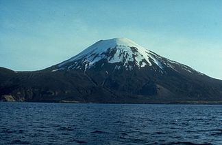
Höhe 1.066 m Lage Aleuten, USA Geographische Lage 52° 30′ 0″ N, 171° 15′ 8″ W52.5-171.252222222221066Koordinaten: 52° 30′ 0″ N, 171° 15′ 8″ W 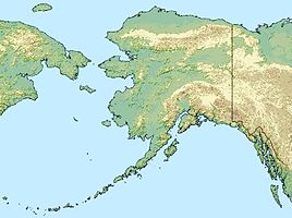

Typ Schichtvulkan Letzte Eruption 1997 Der symmetrische Schichtvulkan Amukta bildet die Insel Amukta mit einem Durchmesser von 7,7 Kilometer und liegt in den zentralen Aleuten, südwestlich der Insel Chagulak, und ist der westlichste der Islands of Four Mountains. Der Vulkan besitzt einen Krater mit einem Durchmesser von 400 Metern. An der Nordwestküste befindet sich ein Schlackenkegel.
Gut dokumentierte Berichte über frühe Aktivitäten des Vulkans sind spärlich. Historische Aufzeichnungen belegen eine explosive Eruptionsphase vom Juni 1786 bis ins Jahr 1791, bei welcher mehrere Millionen Kubikmeter Tephra ausgestossen wurden sowie ein Ausbruch 1878. Bei der Eruption vom 13. Februar 1963 wurden aus dem Zentralkrater sowie aus Seitenkegeln sowohl Asche als auch Lava ausgestoßen. Die Beobachtungsbedingungen waren allerdings wegen Nebels sehr schlecht, aber der Lavastrom konnte beobachtet werden, als er von der Westseite des Kraters bei Traders Cove das Meer erreichte. Ende August und Anfang September 1987 beobachtete ein Pilot einer Verkehrsmaschine eine 10,5 Kilometer hohe Aschewolke über Amukta Island. Weitere Berichte von Piloten über Aschewolken erfolgten am 4. September sowie am 18. September 1987. Anfang Juli 1996 berichtete ein Schiff über eine 1 Kilometer hohe Wolke aus Asche und Rauch und am 3. März 1997 ereignete sich ein explosiver Ausbruch im Zentralkrater des Vulkans.
Weblinks
 Commons: Amukta – Sammlung von Bildern, Videos und Audiodateien
- Amukta Island im Global Volcanism Program der Smithsonian Institution (englisch)
- Alaska Vulkan Observatorium (englisch)
- Amukta Island im Geographic Names Information System des United States Geological Survey
Schlagen Sie auch in anderen Wörterbüchern nach:
Amukta Island — Sp Amùktos salà Ap Amukta Island L Aleutuose, Keturių Kalnų ss., JAV (Aliaska) … Pasaulio vietovardžiai. Internetinė duomenų bazė
Amukta Pass — is a wide strait between the Bering Sea and the North Pacific Ocean in the Aleutian Islands in Alaska. It lies between Amukta Island to the east and Seguam Island to the west. [ Merriam Webster s Geographical Dictionary, Third Edition , p. 45.]… … Wikipedia
Mount Amukta — Amukta Höhe 1.066 m Lage Aleuten, USA … Deutsch Wikipedia
Amukta — Location map Alaska label= lat=52.595595 long= 173.054883 position=right width=250 float=right caption=Location in AlaskaAmukta is a small yet high island in the Islands of Four Mountains group lying between the Fox Islands and the Andreanof… … Wikipedia
Mount Amukta — Mt. Amukta, June 1972 Elevation 3,497 ft (1,066 m) … Wikipedia
Chagulak Island — Location in Alaska … Wikipedia
Chagulak Island — Chagulak Höhe 1.142 m … Deutsch Wikipedia
Nunivak Island — Nunivak Maskette – Nunivak … Wikipedia
Medny Island — Map showing position of Commander Islands to the east of Kamchatka. The smaller island in the east is Medny and the larger island is Bering Island. Medny Island (also spelled Mednyy, Russian: остров Медный, sometimes called Copper Island in… … Wikipedia
Unalaska Island — Unalaska Native name: Nawan Alaxsxa[1] Map of the island … Wikipedia
Amukta Island


18+
© Academic, 2000-2026
- Kontaktieren Sie uns: Unterstützung, Werbung
Wörterbücher Export, schritte mit PHP, Joomla, Drupal, WordPress, MODx.