- Kagamil Island
-
Kagamil Island 
Kagamil
Höhe 893 m Lage Aleuten (Alaska) Geographische Lage 52° 58′ 26″ N, 169° 43′ 4″ W52.97383-169.71783893Koordinaten: 52° 58′ 26″ N, 169° 43′ 4″ W 

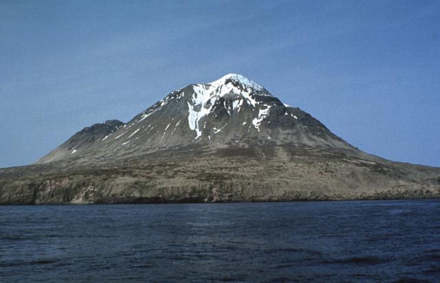
Typ Schichtvulkan Letzte Eruption Dezember 1929 Kagamil Island (aleutisch:Qagaamila) ist die nördlichste Insel der Islands of Four Mountains. Sie liegt 6 km nördlich von Chuginadak Island und ist 2 km südlich von Uliaga Island entfernt. Sie ist 10 km lang und 5 km breit. Die Insel ist schwer zu erreichen.
Der Vulkan
Die südliche Hälfte der Insel wird durch den Kagamil-Vulkan bestimmt. Es handelt sich dabei um einen Schichtvulkan. Dieser hat zwei Gipfel, der höhere liegt 893 m über dem Meeresspiegel, der niedrigere ist 690 m hoch. Von der vulkanischen Aktivität zeugen auch heiße Quellen und Fumarolen an der Süd-Ost-Seite der Insel. Der letzte (bekannte) Ausbruch erfolgte im Dezember 1929.
Weblinks
- Kagamil Island im Global Volcanism Program der Smithsonian Institution (englisch)
- Alaska Vulcano Observatory(engl.)
- National Geographic 1999/2000 (engl.)
- Bild und Kurzbeschreibung (engl.)
- Canadian Mountain Encyclopedia (engl.)
Schlagen Sie auch in anderen Wörterbüchern nach:
Kagamil Island — Location map Alaska label= lat=53.1714 long= 170.9395 position=right width=250 float=right caption=Location in AlaskaKagamil Island (Qagaamila [Bergsland, K Aleut Dictionary Fairbanks: Alaska Native Language Center, 1994] in Aleut), the most… … Wikipedia
Uliaga Island — Höhe 888 m … Deutsch Wikipedia
Nunivak Island — Nunivak Maskette – Nunivak … Wikipedia
Medny Island — Map showing position of Commander Islands to the east of Kamchatka. The smaller island in the east is Medny and the larger island is Bering Island. Medny Island (also spelled Mednyy, Russian: остров Медный, sometimes called Copper Island in… … Wikipedia
Unalaska Island — Unalaska Native name: Nawan Alaxsxa[1] Map of the island … Wikipedia
Nelson Island (Alaska) — Nelson Native name: Qaluyaaq … Wikipedia
Chuginadak Island — Mount Cleveland erupts in 2006. Taken from the International Space Station Geography Location Aleutian Islands, Alaska, USA Coordinates … Wikipedia
Oglodak Island — Island … Wikipedia
Chagulak Island — Location in Alaska … Wikipedia
Chagulak Island — Chagulak Höhe 1.142 m … Deutsch Wikipedia
Kagamil Island

18+
© Academic, 2000-2026
- Kontaktieren Sie uns: Unterstützung, Werbung
Wörterbücher Export, schritte mit PHP, Joomla, Drupal, WordPress, MODx.