- County Fermanagh
-
County Fermanagh
Contae Fhear ManachKarte 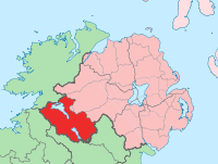
Basisdaten Staat: Vereinigtes Königreich Verwaltungssitz: Enniskillen Provinz: Ulster irischer Name: Fear Manach Fläche: 1698 km² Einwohner: 55.000 (Schätzung) Fermanagh (irisch Fear Manach) ist eine der sechs historischen Grafschaften Nordirlands.
Geografie
Die Grafschaft erstreckt sich rund um den Lower Lough Erne, die Hauptstadt Enniskillen und den Upper Lough Erne. Im Westen erstreckt sich ein Hochland aus Kalkablagerungen, welches aber selten höher als 400 Meter aufragt.
Geschichte
Seit 1956 ist die County-Hauptstadt Enniskillen eine Partnerstadt von Brackwede (Stadtbezirk von Bielefeld).
 Historische Grafschaften (counties) von Nordirland
Antrim | Armagh | Down | Fermanagh | Londonderry | Tyrone
Wikimedia Foundation.
Schlagen Sie auch in anderen Wörterbüchern nach:
County Fermanagh — Contae Fhear Manach Coontie Fermanagh Coat of arms … Wikipedia
Boho, County Fermanagh — Infobox Irish Place|thumb|left|name = Boho irish = Botha map pin coords = north coord = | west coord = province = Ulster county = County Fermanagh NI district = Fermanagh UK constituency = Fermanagh and South Tyrone stdcode = 028, +44 28 posttown … Wikipedia
Belleek, County Fermanagh — Infobox UK place official name= Belleek irish name= Béal Leice scots name= local name= static static image caption= map type= Northern Ireland latitude= 54.482106470178756 longitude= 8.08666706085205 belfast distance= 104 miles population= 836… … Wikipedia
Lack, County Fermanagh — Infobox Irish Place|thumb|left|name = Lack irish = An Leac scots = map pin coords = north coord = | west coord = province = Ulster county = County Fermanagh NI district = Fermanagh UK constituency = Fermanagh and South Tyrone stdcode = 028, +44… … Wikipedia
Tempo, County Fermanagh — Infobox Irish Place|thumb|left|name = Tempo irish = An Tiompú Deiseal scots = map pin coords = left: 47px; top: 110px north coord = 54.381 west coord = 7.453 province = Ulster county = County Fermanagh NI district = Fermanagh UK constituency =… … Wikipedia
Kesh, County Fermanagh — Infobox Irish Place|thumb|left|name = Kesh irish = An Cheis scots = map pin coords = north coord = 54.522 | west coord = 7.723 province = Ulster county = County Fermanagh NI district = Fermanagh UK constituency = Fermanagh and South Tyrone… … Wikipedia
Holywell, County Fermanagh — Infobox Irish Place|thumb|left|name = Holywell irish = Dabhach Phádraig scots = map pin coords = north coord = | west coord = province = Ulster county = County Fermanagh NI district = Fermanagh UK constituency = Fermanagh and South Tyrone stdcode … Wikipedia
Garrison, County Fermanagh — Infobox Irish Place|thumb|left|name = Garrison irish = An Garastún scots = map pin coords = north coord = 54.415 | west coord = 8.091 province = Ulster county = County Fermanagh NI district = Fermanagh UK constituency = Fermanagh and South Tyrone … Wikipedia
Laragh, County Fermanagh — Infobox Irish Place|thumb|left|name = Laragh irish = An Láithreach map pin coords = north coord = | west coord = province = Ulster county = County Fermanagh NI district = Fermanagh UK constituency = Fermanagh and South Tyrone stdcode = 028, +44… … Wikipedia
Tamlaght, County Fermanagh — Tamlaght (Irish: Tamhlacht , meaning plague burial place ) is a village in County Fermanagh, Northern Ireland, 4 miles east of Enniskillen. In the 2001 Census it had a population of 276 people. It is situated in the Fermanagh District Council… … Wikipedia
County Fermanagh

18+
© Academic, 2000-2026
- Kontaktieren Sie uns: Unterstützung, Werbung
Wörterbücher Export, schritte mit PHP, Joomla, Drupal, WordPress, MODx.