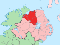
- County Londonderry
-
County Londonderry
Contae DhoireKarte 
Basisdaten Staat: Vereinigtes Königreich Verwaltungssitz: Londonderry Provinz: Ulster irischer Name: Contae Dhoire Fläche: 2074 km² Einwohner: 213.000 (Schätzung) Londonderry (irisch Doire) ist eine der sechs historischen Grafschaften Nordirlands. Von Bewohnern der Republik Irland oder katholischen Nordiren wird aus politischen Gründen der Name Derry verwendet.
Inhaltsverzeichnis
Geografie
Die Grafschaft (county) liegt zwischen Lough Foyle, Lough Neagh und dem Fluss Bann. Sie umfasst ein fruchtbares Flachland, das teilweise aus Basalt, teilweise aus Kalksteinen aufgebaut und zum Großteil mit eiszeitlichen Ablagerungen bedeckt ist. Im Westen liegt das Bergland der Sperrin Mountains.
Geschichte
Im Mittelalter gehörte das Gebiet zum Königreich Ulster, später zu Aileach bzw. Tyrone. Die Grafschaft wurde 1635 unter dem Namen County Coleraine gebildet, ihren heutigen Namen erhielt sie 1613. Seit 1920 gehört die Grafschaft zu Großbritannien.
Wirtschaft
Die Industrie konzentriert sich auf die Stadt Derry und Coleraine. Hier gibt es Leinenindustrie, Schiffbau und chemische Industrie. In der Landwirtschaft herrschen Schafzucht und Anbau von Hafer und Kartoffeln vor. An der Küste gibt es einige wichtige Fischereihäfen, außerdem das Seebad Portsteward.
Städte
Sehenswürdigkeiten
- Ballybriest Court tomb
- Ballygroll
- Boviel Wedge tomb
- Kilhoyle
- Knockoneill
- Montrudel Fort
- Tirnony
Persönlichkeiten
- Seamus Heaney (* 1939), irischer Schriftsteller, Literatur-Nobelpreisträger 1995
Schlagen Sie auch in anderen Wörterbüchern nach:
County Londonderry — For other places with similar names, see Londonderry (disambiguation) and Derry (disambiguation). County Londonderry / County Derry Contae Dhoire Coontie Lunnonderrie … Wikipedia
Banagher, County Londonderry — Coordinates: 54°53′31″N 7°01′52″W / 54.892°N 7.031°W / 54.892; 7.031 For the place in … Wikipedia
Curran, County Londonderry — Curran (from Irish: an Corrán, meaning the cresent )[1] is a small village and townland in County Londonderry, Northern Ireland. In the 2001 Census it had a population of 132 people. It is within the Magherafelt District Council area,… … Wikipedia
Crew, County Londonderry — Crew is a townland lying within the civil parish of Maghera, County Londonderry, Northern Ireland. It lies in the east centre of the parish on the north boundary of the civil parish of Termoneeny, and is bounded by the townlands of Ballymacilcurr … Wikipedia
Downhill, County Londonderry — Downhill (formerly called Dunbo, from Irish: Dún Bó, meaning fort of the cows )[1] is a small village and townland near Castlerock in County Londonderry, Northern Ireland. Contents 1 History 2 Transport … Wikipedia
Ballykelly, County Londonderry — For other places with the same name, see Ballykelly Infobox UK place official name= Ballykelly irish name= Baile Uí Cheallaigh scots name= static static image caption=The village centre, located on the A2 map type= Northern Ireland latitude=… … Wikipedia
Clady, County Londonderry — Coordinates: 54°52′11″N 6°30′31″W / 54.8697°N 6.5085°W / 54.8697; 6.5085 Clady (from Irish … Wikipedia
Eglinton, County Londonderry — Infobox UK place official name= Eglinton irish name= An Mhagh scots name= local name= static static image caption= map type= Northern Ireland latitude= 55.040397 longitude= 7.175047 belfast distance= population= 3,165 (2001 Census) irish grid… … Wikipedia
Lord Lieutenant of County Londonderry — This is a list of people to have been Lord Lieutenant of County Londonderry. The office was created on 23 August 1831.County Londonderry*George Canning, 1st Baron Garvagh 7 October 1831 – 20 August 1840 *Sir Robert Ferguson, 2nd Baronet 1840 – 13 … Wikipedia
Tamlaght, County Londonderry — Tamlaght (Irish: Tamhlacht; meaning Burial place ) is a small village in County Londonderry, Northern Ireland. In the 2001 Census it had a population of 123 people. It is situated in the Magherafelt District Council area.Tamhlacht or Tallaght is… … Wikipedia
