- Dawson County (Nebraska)
-
Verwaltung US-Bundesstaat: Nebraska Verwaltungssitz: Lexington Adresse des
Verwaltungssitzes:County Courthouse
700 N Washington
P.O. Box 370
Lexington, NE 68850-0370Gründung: 1860 Gebildet aus: Indianerland Vorwahl: 001 308 Demographie Einwohner: 24.326 (2010) Bevölkerungsdichte: 9,3 Einwohner/km² Geographie Fläche gesamt: 2.640 km² Wasserfläche: 16 km² Karte 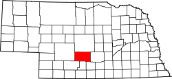
Website: dawsoncone.com Dawson County[2] ist ein County im US-amerikanischen Bundesstaat Nebraska. Bei der Volkszählung im Jahr 2010 hatte das County 24.326 Einwohner und eine Bevölkerungsdichte von 9,3 Einwohnern pro Quadratkilometer. Der Verwaltungssitz (County Seat) ist Lexington[3], das nach der Schlacht von Lexington im amerikanischen Revolutionskrieg benannt wurde.
Inhaltsverzeichnis
Geografie
Das County liegt südlich des geografischen Zentrums von Nebraska und hat eine Fläche von 2.640 Quadratkilometern, wovon 16 Quadratkilometer Wasserfläche sind. Es grenzt an folgende Countys:
Custer County Lincoln County 
Buffalo County Frontier County Gosper County Phelps County Geschichte
Das Dawson County wurde 1860 auf ehemaligem Indianerland gebildet. Benannt wurde es nach John Littleton Dawson (1813-1870), einem Abgeordneten des Repräsentantenhauses der USA (1851-1855, 1863-1867).
Demografische Daten
Historische Einwohnerzahlen Census Einwohner ± in % 1860 16 — 1870 103 500 % 1880 2909 3.000 % 1890 10.129 200 % 1900 12.264 20 % 1910 15.961 30 % 1920 16.004 0,3 % 1930 17.875 10 % 1940 17.890 0,08 % 1950 19.393 8 % 1960 19.405 0,06 % 1970 19.771 2 % 1980 22.304 10 % 1990 19.940 -10 % 2000 24.365 20 % 2010 24.326 -0,2 % Vor 1900[4] 1900–1990[5] 2000[6] 2010[7] Nach der Volkszählung im Jahr 2010 lebten im Dawson County 24.326 Menschen in 8.821 Haushalten. Die Bevölkerungsdichte betrug 9,3 Einwohner pro Quadratkilometer.
Ethnisch betrachtet setzte sich die Bevölkerung zusammen aus 78,0 Prozent Weißen, 3,1 Prozent Afroamerikanern, 0,8 Prozent amerikanischen Ureinwohnern, 0,6 Prozent Asiaten sowie aus anderen ethnischen Gruppen; 2,1 Prozent stammten von zwei oder mehr Ethnien ab. Unabhängig von der ethnischen Zugehörigkeit waren 31,8 Prozent der Bevölkerung spanischer oder lateinamerikanischer Abstammung.
In den 8.821 Haushalten lebten statistisch je 2,78 Personen.
30,3 Prozent der Bevölkerung waren unter 18 Jahre alt, 56,9 Prozent waren zwischen 18 und 64 und 12,8 Prozent waren 65 Jahre oder älter. 49,0 Prozent der Bevölkerung war weiblich.
Das jährliche Durchschnittseinkommen eines Haushalts lag bei 40.048 USD. Das Pro - Kopf - Einkommen betrug 18.853 USD. 14,8 Prozent der Einwohner lebten unterhalb der Armutsgrenze.[8]
Städte und Gemeinden
- Cozad
- Gothenburg
- Lexington
- Eddyville
- Farnam
- Overton
- Sumner
- Darr
- Willow Island
Einzelnachweise
- ↑ Auszug aus dem National Register of Historic Places Abgerufen am 13. März 2011
- ↑ GNIS-ID: 835845. Abgerufen am 22. Februar 2011 (englisch).
- ↑ National Association of Counties Abgerufen am 25. September 2011
- ↑ U.S. Census Bureau _ Census of Population and Housing Abgerufen am 17. Februar 2011
- ↑ Auszug aus Census.gov Abgerufen am 17. Februar 2011
- ↑ Auszug aus factfinder.census.gov Abgerufen am 18. Februar 2011
- ↑ United States Census 2010 Abgerufen am 25. September 2011
- ↑ U.S. Census Buero, State & County QuickFacts - Dawson County Abgerufen am 25. September 2011
Weblinks
-
 Commons: Dawson County, Nebraska – Sammlung von Bildern, Videos und Audiodateien
 - Offizielle Webseite
- U.S. Census Buero, State & County QuickFacts - Dawson County
- Yahoo Bildersuche - Dawson County
- www.city-data.com - Dawson County

Liste der Countys in Nebraska
Adams | Antelope | Arthur | Banner | Blaine | Boone | Box Butte | Boyd | Brown | Buffalo | Burt | Butler | Cass | Cedar | Chase | Cherry | Cheyenne | Clay | Colfax | Cuming | Custer | Dakota | Dawes | Dawson | Deuel | Dixon | Dodge | Douglas | Dundy | Fillmore | Franklin | Frontier | Furnas | Gage | Garden | Garfield | Gosper | Grant | Greeley | Hall | Hamilton | Harlan | Hayes | Hitchcock | Holt | Hooker | Howard | Jefferson | Johnson | Kearney | Keith | Keya Paha | Kimball | Knox | Lancaster | Lincoln | Logan | Loup | Madison | McPherson | Merrick | Morrill | Nance | Nemaha | Nuckolls | Otoe | Pawnee | Perkins | Phelps | Pierce | Platte | Polk | Red Willow | Richardson | Rock | Saline | Sarpy | Saunders | Scotts Bluff | Seward | Sheridan | Sherman | Sioux | Stanton | Thayer | Thomas | Thurston | Valley | Washington | Wayne | Webster | Wheeler | York
Wikimedia Foundation.
Schlagen Sie auch in anderen Wörterbüchern nach:
Dawson County, Nebraska — Dawson County Courthouse in Lexington … Wikipedia
Dawson County Courthouse (Nebraska) — Dawson County Courthouse U.S. National Register of Historic Places U.S. Historic district … Wikipedia
Dawson County — is the name of several counties in the United States: Dawson County, Georgia (Located in the Atlanta Metropolitan Area) Dawson County, Montana Dawson County, Nebraska Dawson County, Texas This disambiguation page lists articles about distinct… … Wikipedia
Dawson County — Es gibt in den USA vier Countys mit dem Namen Dawson County: Dawson County (Georgia) Dawson County (Montana) Dawson County (Nebraska) Dawson County (Texas) Diese Seite ist eine … Deutsch Wikipedia
Dawson County Courthouse — may refer to: Dawson County Courthouse (Georgia), listed on the NRHP in Georgia Dawson County Courthouse (Nebraska), listed on the NRHP in Nebraska This disambiguation page lists articles associated with the same title. If an … Wikipedia
Dawson County Courthouse (Georgia) — Dawson County Courthouse U.S. National Register of Historic Places … Wikipedia
Dawson County Courthouse — bezeichnet mehrere gleichnamige, im NRHP gelistete, Objekte: Dawson County Courthouse (Georgia), NRHP Nr. 80001010 Dawson County Courthouse (Nebraska), NRHP Nr. 89002236 Diese Seite ist eine Begriffsklärung zur Unterscheidung m … Deutsch Wikipedia
Custer County, Nebraska — Custer County Courthouse in Broken Bow, Nebraska … Wikipedia
Lincoln County, Nebraska — Infobox U.S. County county = Lincoln County state = Nebraska founded = Information needed seat wl = North Platte largest city wl = North Platte area total sq mi =2575 area land sq mi =2564 area water sq mi =11 area percentage = 0.43% census yr =… … Wikipedia
Buffalo County, Nebraska — Infobox U.S. County county = Buffalo County state = Nebraska founded = 1855 seat = Kearney | largest city = Kearney area total sq mi =975 area land sq mi =968 area water sq mi =7 area percentage = 0.75% census yr = 2000 pop = 42259 density km2… … Wikipedia
Dawson County (Nebraska)


18+
© Academic, 2000-2026
- Kontaktieren Sie uns: Unterstützung, Werbung
Wörterbücher Export, schritte mit PHP, Joomla, Drupal, WordPress, MODx.