Des Moines River

Des Moines River
Des Moines River
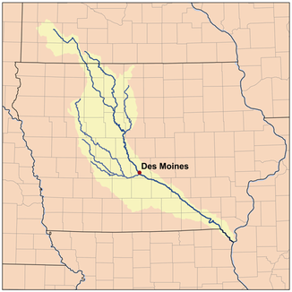
Einzugsgebiet des Des Moines Rivers

Einzugsgebiet des Des Moines Rivers

Daten
Gewässerkennzahl US465582
Lage Minnesota, Iowa (USA)
Flusssystem Mississippi River
Abfluss über Mississippi → Golf von Mexiko
Quelle Lake Shetek
44° 5′ 2″ N, 95° 41′ 17″ W44.0838509-95.6880668
Vorlage:Infobox Fluss/QUELLHÖHE_fehlt
Mündung Mississippi River bei Keokuk
41.3811553-91.4223753182

41° 22′ 52″ N, 91° 25′ 21″ W41.3811553-91.4223753182
Mündungshöhe 182 m[1]Vorlage:Infobox Fluss/HÖHENUNTERSCHIED_fehlt
Länge 845 kmVorlage:Infobox Fluss/NACHWEISE_fehlen
Einzugsgebiet 38.340 km²Vorlage:Infobox Fluss/NACHWEISE_fehlen
AbflussmengeVorlage:Infobox Fluss/NACHWEISE_fehlen MQ: 246 m³/s
Rechte Nebenflüsse Raccoon River
Linke Nebenflüsse Boone River
Durchflossene Stauseen Saylorville Lake, Lake Red Rock
Großstädte Des Moines
Mittelstädte Ottumwa
Kleinstädte Keokuk
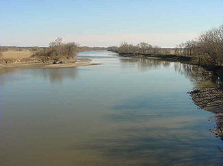
Der Des Moines River oberhalb von Ottumwa (Iowa)

Der Des Moines River oberhalb von Ottumwa (Iowa)

Der Des Moines River ist ein etwa 845 km (525 Meilen) langer Zufluss des Mississippi River im oberen mittleren Westen der USA. Er entspringt im südlichen Minnesota, durchfließt Iowa von Nordwesten nach Südosten und mündet schließlich bei Keokuk in den Mississippi. Die Staatshauptstadt Des Moines verdankt diesem größten Fluss Iowas ihren Namen.

Die Herkunft des Namens ist nicht ganz klar. Ursprünglich wurde er wohl von französischen Entdeckern La Rivière des Moines, also „Mönchsfluss“ genannt. Allerdings gibt es auch noch andere Theorien.

Vor dem Bau der großen Eisenbahnlinien (ca. 1860) war der Des Moines der Haupttransportweg durch Iowa. Während eines historischen Hochwassers 1993 mussten die Stadt Des Moines und benachbarte Gemeinden teilweise evakuiert werden.

Inhaltsverzeichnis

Orte, die an diesem Fluss liegen

  • Algona
  • Armstrong
  • Bonaparte
  • Chillicothe
  • Currie
  • Dakota City
  • Des Moines
  • Douds
  • Eddyville
  • Eldon
  • Estherville
  • Farmington
  • Fort Dodge
  • Fraser
  • Graettinger
  • Humboldt
  • Jackson
  • Johnston
  • Keokuk
  • Keosauqua
  • Lehigh
  • Leando
  • Ottumwa
  • Rutland
  • Windom

Andere Namen

Gemäß dem Geographic Names Information System ist/war der Des Moines River auch bekannt als:

  • La Riviere des Moins
  • Le Moine River
  • Monk River
  • Nadouessioux River
  • Outontantes River
  • River Demoin
  • River of the Maskoutens
  • River of the Peouareas

Siehe auch

Weblinks

Einzelnachweise

  1. USGS - Geographic Names Information System - Des Moines River

Wikimedia Foundation.

Игры ⚽ Поможем написать курсовую

Schlagen Sie auch in anderen Wörterbüchern nach:

  • Des Moines River — River, southwestern Minnesota into Iowa, U.S. Rising near Pipestone, it flows 525 mi (845 km) southeast to join the Mississippi River near Keokuk, Iowa. Above Humboldt, Iowa, it is known as the West Fork. From the late 1830s until the end of the… …   Universalium

  • Des Moines River — Coordinates: 40°22′52″N 91°25′21″W / 40.3812°N 91.4224°W / 40.3812; 91.4224 …   Wikipedia

  • Des Moines River Township, Murray County, Minnesota — Des Moines River Township, Minnesota   Township   …   Wikipedia

  • Des Moines River Bridge — may refer to: Des Moines River Bridge (Humboldt, Iowa), listed on the National Register of Historic Places in Humboldt County, Iowa Des Moines River Bridge (Swea City, Iowa), listed on the National Register of Historic Places in Kossuth County,… …   Wikipedia

  • Des Moines River Bridge — bezeichnet mehrere gleichnamige, im NRHP gelistete, Objekte: Des Moines River Bridge (Humboldt County, Iowa), NRHP Nr. 98000522 Des Moines River Bridge (Kossuth County, Iowa), NRHP Nr. 98000535 Diese Seite ist eine Begriffsklärung …   Deutsch Wikipedia

  • Des Moines River Bridge (Humboldt, Iowa) — Highway 3 Bridge U.S. National Register of Historic Places Invalid designation …   Wikipedia

  • Municipio de Des Moines River (condado de Murray, Minnesota) — Municipio de Des Moines River Municipio de los Estados Unidos …   Wikipedia Español

  • Lake Red Rock (Des Moines River) — Infobox lake lake name = Lake Red Rock image lake = Red Rock Lake Des Moines River.jpg caption lake = (Army Corps of Engineers) image bathymetry = caption bathymetry = location = Marion County, Iowa coords =… …   Wikipedia

  • Competine Creek (Des Moines River) — Coordinates: 41°22′04″N 93°02′18″W / 41.3677°N 93.0383°W / 41.3677; 93.0383 …   Wikipedia

  • Beaver Creek (Des Moines River) — Beaver Creek is a tributary of the Des Moines River that rises at the northern border of Boone County in the U.S. state of Iowa, and then flows generally south and southeast through western Boone County, northeastern Dallas County, and finally… …   Wikipedia

Share the article and excerpts

Direct link
Do a right-click on the link above
and select “Copy Link”