- East Burra
-
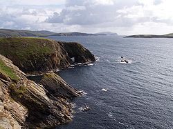
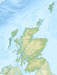
East Burra Die Südspitze von East Burra Gewässer <<<<<<<<nordsee Inselgruppe Shetlandinseln Geographische Lage 60° 5′ N, 1° 18′ W60.088888888889-1.301666666666781Koordinaten: 60° 5′ N, 1° 18′ W Länge 14 km Breite 1,5 km Fläche 5,15 km² Höchste Erhebung 81 m Einwohner 66 (2001)
13 Einw./km²East Burra ist eine kleine schottische Insel, die zur Gruppe der Shetlandinseln gehört.
Sie liegt im Südwesten zwischen der Hauptinsel Mainland und der östlich gelegenen Nachbarinsel West Burra. Zu beiden Inseln besteht eine Brücken- und Straßenverbindung, so dass mittlerweile der Hauptort der Shetlands, Lerwick, problemlos zu erreichen ist. Durch die Brückenverbindungen konnte die Entvölkerung der Insel aufgehalten werden, so dass die Einwohnerzahl nun recht konstant bei 66 liegt.
Obgleich immer mehr Einwohner in Lerwick arbeiten, spielt die Fischerei und die Landwirtschaft immer noch eine gewisse Rolle.
Die Insel ist ca. 14 km lang, bis zu 1,5 km breit und hat eine Größe etwas über 5 km². Sie ist leicht hügelig und praktisch baumlos.
Weblinks
 Commons: East Burra – Sammlung von Bildern, Videos und Audiodateien
- Virtuelle Reise über die Insel
- Informationen über die Shetlands (auf englisch)
- Bevölkerungszahlen schottischer Inseln
Inseln der ShetlandinselnBalta | Bressay | East Burra | West Burra | Fair Isle | Fetlar | Foula | Mainland | Mousa | Muckle Flugga | Muckle Roe | Noss | Out Stack | Papa Stour | Trondra | Unst | Vaila | Whalsay | Yell
Wikimedia Foundation.
Schlagen Sie auch in anderen Wörterbüchern nach:
East Burra — Infobox Scottish island | GridReference=HU388339 celtic name= norse name=Barrey meaning of name= area= 515 ha area rank= 73 highest elevation= 81 m Population=66 population rank= 52 main settlement= island group=Shetland local authority=Shetland… … Wikipedia
Burra, New South Wales — Burra is an Australian district and parish of rural smallholdings lying 20 kilometers to the south of Queanbeyan, New South Wales in Palerang Council, postcode 2620. The districts bounds have been defined [cite book | last = Moore | first = Bruce … Wikipedia
Burra (disambiguation) — Burra may refer to:Places* Burra, the collective name for two of the Shetland Islands ** West and East Burra. *Burra, South Australia, a pastoral centre and historic tourist town in the mid north of South Australia. * Burra, New South Wales, a… … Wikipedia
Burra — bezeichnet: die Stadt Burra (Australien) (33|40|S, 138|56|E) die Shetlandinseln East Burra und West Burra den Maler Edward Burra Diese Seite ist eine Begriffsklärung zur Unte … Deutsch Wikipedia
Burra — (Old Norse: Barrey [Anderson, Joseph (Ed.) (1893) Orkneyinga Saga . Translated by Jón A. Hjaltalin Gilbert Goudie. Edinburgh. James Thin and Mercat Press (1990 reprint). ISBN 0 901824 25 9] ) is the collective name for two of the Shetland Islands … Wikipedia
Burra Burra Mine (Tennessee) — Burra Burra Mine Historic District U.S. National Register of Historic Places U.S. Historic district … Wikipedia
Burra and Quarff — BURRA and QUARFF, late a quoad sacra parish, in the parish of Bressay, county of Orkney and Shetland; containing 870 inhabitants. The district of Burra lies west of the Mainland, from which it is separated by Cliff Sound, and comprehends the… … A Topographical dictionary of Scotland
Burra, South Australia — Infobox Australian Place | type = town name = Burra state = sa caption = Location of Burra in South Australia lga = Regional Council of Goyder postcode = 5417 pop = 978 [Census 2006 AUS|id=SSC43246 | name = Burra (State Suburb) |quick=on |… … Wikipedia
Burra Burra Mine (United States) — Infobox nrhp name =Burra Burra Mine Historic District nrhp type = hd caption = Burra Burra Mine collapse site location = Ducktown, Tennessee nearest city = lat degrees = lat minutes = lat seconds = lat direction = long degrees = long minutes =… … Wikipedia
West Burra — w1 West Burra Die Brücke von West Burra nach Trondra Gewässer … Deutsch Wikipedia


