- Fujiidera
-
Fujiidera-shi
藤井寺市

Geographische Lage in Japan Region: Kinki Präfektur: Ōsaka Koordinaten: 34° 34′ N, 135° 36′ O34.574283333333135.597475Koordinaten: 34° 34′ 27″ N, 135° 35′ 51″ O Basisdaten Fläche: 8,89 km² Einwohner: 66.166
(1. Juli 2011)Bevölkerungsdichte: 7.443 Einwohner je km² Gemeindeschlüssel: 27226-4 Symbole Baum: Ume Blume: Garten-Chrysantheme Rathaus Adresse: Fujiidera City Hall
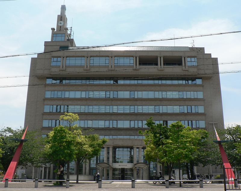
1-1-1, Oka
Fujiidera-shi
Ōsaka 583-8583Webadresse: http://www.city.fujiidera.osaka.jp Lage Fujiideras in der Präfektur Ōsaka 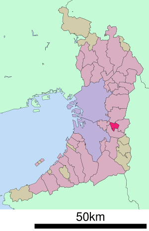
Fujiidera (jap. 藤井寺市, -shi) ist eine Stadt in der Präfektur Ōsaka in Japan.
Inhaltsverzeichnis
Geographie
Fujiidera liegt nordöstlich von Sakai und südöstlich von Ōsaka.
Geschichte
Fujiidera wurde am 1. November 1966 gegründet.
Sehenswürdigkeiten
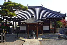 Fujii-dera
- AICEL Shura Hall (アイセルシュラホール, Aiseru shura hōru)
- buddhistische Tempel:
- Fujii-dera (藤井寺)
- Dōmyō-ji (道明寺)
- Dōmyō-ji Tenman-gū (道明寺天満宮, Shintō-Schrein)
Angrenzende Städte und Gemeinden
Verkehr
- Zug
- Kintetsu-Minamiosaka-Linie
- Straße:
- Nationalstraße 170
Weblinks
 Commons: Fujiidera – Sammlung von Bildern, Videos und Audiodateien
 Rathaus von Fujiidera
 Gemeinden und Landkreise in der Präfektur Ōsaka
Kreisfreie Städte (shi): Daitō | Fujiidera | Habikino | Hannan | Higashiōsaka | Hirakata | Ibaraki | Ikeda | Izumi | Izumiōtsu | Izumisano | Kadoma | Kaizuka | Kashiwara | Katano | Kawachinagano | Kishiwada | Matsubara | Minō | Moriguchi | Neyagawa | Ōsaka (Verwaltungssitz) | Ōsakasayama | Sakai | Sennan | Settsu | Shijōnawate | Suita | Takaishi | Takatsuki | Tondabayashi | Toyonaka | Yao
Minamikawachi-gun: Chihaya-Akasaka | Kanan | Taishi | Mishima-gun: Shimamoto | Semboku-gun: Tadaoka | Sennan-gun: Kumatori | Misaki | Tajiri | Toyono-gun: Nose | Toyono
Wikimedia Foundation.
Schlagen Sie auch in anderen Wörterbüchern nach:
Fujiidera Stadium — was a multi use stadium in Osaka, Japan. It is currently used mostly for baseball and was the home of the Kintetsu Buffaloes prior to the Osaka Dome opening in 1997. The stadium holds 32,000 people. The stadium was built in 1928.External links*… … Wikipedia
Fujiidera, Osaka — Infobox City Japan Name=Fujiidera JapaneseName=藤井寺市 Prefecture=Osaka Region=Kansai Area km2=8.89 Population=66,442 PopDate=May 31, 2005 Density km2=7473.79 Coords=coord|34|34|N|135|36|E|type:city region:JP Mayor=Kazuhiko Iseki Tree=Ume… … Wikipedia
Fujiidera (Osaka) — 藤井寺市 Fujiidera … Wikipedia Español
Fujiidera Station — is a train station in Fujiidera, Osaka Prefecture, Japan.Lines*Kintetsu:*Minami Osaka LineLayoutAdjacent stations !colspan=5|Kintetsu ###@@@KEYEND@@@### … Wikipedia
Fujiidera-shi — Admin ASC 2 Code Orig. name Fujiidera shi Country and Admin Code JP.32.1864125 JP … World countries Adminstrative division ASC I-II
Habikino, Osaka — Infobox City Japan Name=Habikino JapaneseName=羽曳野市 Prefecture=Osaka Region=Kansai Area km2=26.44 Population=120,894 PopDate=June 30, 2005 Density km2=4572.39 Coords= LatitudeDegrees= 34 LatitudeMinutes= 33 LatitudeSeconds= LongtitudeDegrees= 135… … Wikipedia
Osaka Prefectural Board of Education — is a branch of the government of Osaka Prefecture, Japan. The board supervises individual municipal school systems and directly operates public high schools in Osaka prefecture. Contents 1 Schools operated by the prefecture 1.1 High schools… … Wikipedia
Mikirō Sasaki — For the chairman of Mitsubishi Corporation, see Mikio Sasaki. Mikirō Sasaki (佐々木幹郎) , also Mikio Sasaki, (b. 20 October 1947) is a Japanese poet and travel author, winner of the 2003 Yomiuri Prize for travel essays. Sasaki won the award for his… … Wikipedia
Nishi-Meihan Expressway — 西名阪自動車道 Route information Length: 27.2 km (16.9 mi) … Wikipedia
Osaka Prefecture — Japanese transcription(s) – Japanese 大阪府 – Rōmaji Ōsaka fu … Wikipedia
Fujiidera


18+
© Academic, 2000-2026
- Kontaktieren Sie uns: Unterstützung, Werbung
Wörterbücher Export, schritte mit PHP, Joomla, Drupal, WordPress, MODx.