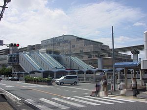
- Ikeda (Ōsaka)
-
Ikeda-shi
池田市Geographische Lage in Japan Region: Kinki Präfektur: Ōsaka Koordinaten: 34° 49′ N, 135° 26′ O34.816666666667135.43333333333Koordinaten: 34° 49′ 0″ N, 135° 26′ 0″ O Basisdaten Fläche: 22,11 km² Einwohner: 104.008
(1. Juli 2011)Bevölkerungsdichte: 4.704 Einwohner je km² Gemeindeschlüssel: 27204-3 Symbole Flagge/Wappen: Baum: Campherbaum Blume: Rhododendron indicum Rathaus Adresse: Ikeda City Hall
1-1-1, Jonan
Ikeda-shi
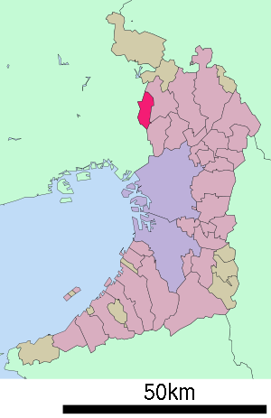
Ōsaka 563-8666Webadresse: http://www.city.ikeda.osaka.jp Lage Ikedas in der Präfektur Ōsaka 
Ikeda (jap. 池田市, -shi) ist eine Stadt in der Präfektur Ōsaka in Japan.
Inhaltsverzeichnis
Geographie
Ikeda liegt nördlich von Ōsaka und östlich von Amagasaki.
Geschichte
Ikeda wurde am 29. April 1939 gegründet.
Verkehr
- Straße:
- Chugoku-Autobahn
- Nationalstraßen 171, 173, 176, 477
- Zug:
- Hankyū Takarazuka-Hauptlinie
- Hankyū Minoo-Linie
Städtepartnerschaften
 Launceston (Tasmanien), Schwesterstadt seit 1965
 Suzhou (Jiangsu), Partnerstadt seit 1981
Söhne und Töchter der Stadt
- Kamon Iizumi (* 1960), Politiker
- Daidō Moriyama (* 1938), Fotograf
- Masayuki Naoshima (* 1945), Politiker
Angrenzende Städte und Gemeinden
- Präfektur Ōsaka
- Präfektur Hyōgo
Weblinks
 Commons: Ikeda (Ōsaka) – Sammlung von Bildern, Videos und AudiodateienGemeinden und Landkreise in der Präfektur Ōsaka
Kreisfreie Städte (shi): Daitō | Fujiidera | Habikino | Hannan | Higashiōsaka | Hirakata | Ibaraki | Ikeda | Izumi | Izumiōtsu | Izumisano | Kadoma | Kaizuka | Kashiwara | Katano | Kawachinagano | Kishiwada | Matsubara | Minō | Moriguchi | Neyagawa | Ōsaka (Verwaltungssitz) | Ōsakasayama | Sakai | Sennan | Settsu | Shijōnawate | Suita | Takaishi | Takatsuki | Tondabayashi | Toyonaka | Yao
Minamikawachi-gun: Chihaya-Akasaka | Kanan | Taishi | Mishima-gun: Shimamoto | Semboku-gun: Tadaoka | Sennan-gun: Kumatori | Misaki | Tajiri | Toyono-gun: Nose | Toyono
Wikimedia Foundation.
Schlagen Sie auch in anderen Wörterbüchern nach:
Ikeda, Osaka — Infobox City Japan Name= Ikeda JapaneseName= 池田市 Map Region= Kansai Prefecture= Osaka District= Area km2= 22.09 PopDate= April 2008 Population= 104,314 Density km2= 4720 Coords= LatitudeDegrees= 34 LatitudeMinutes= 49 LatitudeSeconds=… … Wikipedia
Ikeda — (jap. 池田 Ikeda, wörtlich „Reisfeld am Teich“) ist ein japanischer Familien und Ortsname. Ikeda ist der Name folgender Orte: Ikeda (Ōsaka), einer Stadt in der Präfektur Ōsaka Die folgenden Kleinstädte Ikeda (池田町; Ikeda chō oder Ikeda machi) Ikeda… … Deutsch Wikipedia
Osaka International Airport — Itami International Airport 大阪国際空港 Ōsaka Kokusai Kūkō IATA: ITM – ICAO: RJOO … Wikipedia
Ikeda Station — (池田駅) is the name of four train stations in Japan:# Ikeda Station (Hokkaido) in Ikeda, Nakagawa District, Hokkaidō on the JR Hokkaidō Nemuro Main Line # Ikeda Station (Osaka) in Ikeda, Osaka Prefecture on the Hankyu Takarazuka Line # Awa Ikeda… … Wikipedia
Osaka school massacre — Location Ikeda, Osaka, Japan Date June 8, 2001 Attack type mass murder, stabbing Weapon(s) … Wikipedia
Ōsaka Kyōiku Daigaku — Tennōji Campus Die Pädagogische Hochschule Ōsaka (jap. 大阪教育大学, Ōsaka kyōiku daigaku, kurz: 大教大, Daikyōdai) ist eine staatliche Hochschule in Japan. Der Hauptcampus liegt in Kashiwara, Präfektur Ōsaka. Sie ist die einzige japanische pädagogische… … Deutsch Wikipedia
Ikeda — is a Japanese surname and place name, literally meaning rice paddy by the pond .Place names* the city of Ikeda, Osaka (Japanese: 池田市; Ikeda shi ) in Osaka Prefecture, Japan * any of the following towns named Ikeda (Japanese: 池田町; ikeda cho or… … Wikipedia
Osaka — 大阪市 Ōsaka shi Geographische Lage in Japan … Deutsch Wikipedia
Ôsaka — 大阪市 Ōsaka shi Geographische Lage in Japan … Deutsch Wikipedia
Osaka Prefectural Board of Education — is a branch of the government of Osaka Prefecture, Japan. The board supervises individual municipal school systems and directly operates public high schools in Osaka prefecture. Contents 1 Schools operated by the prefecture 1.1 High schools… … Wikipedia
- Straße:


