- Hancock County (Indiana)
-
Verwaltung US-Bundesstaat: Indiana Verwaltungssitz: Greenfield Adresse des
Verwaltungssitzes:County Courthouse
9 E. Main
Greenfield, IN 46140-2320Gründung: 26. Januar 1827 Gebildet aus: Madison County Vorwahl: 001 317 Demographie Einwohner: 55.391 (2000) Bevölkerungsdichte: 69,9 Einwohner/km² Geographie Fläche gesamt: 794 km² Wasserfläche: 2 km² Karte 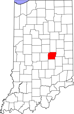
Website: www.hancockcoingov.org Hancock County[1] ist ein County im Bundesstaat Indiana der Vereinigten Staaten von Amerika. Der Verwaltungssitz (County Seat) ist Greenfield.
Inhaltsverzeichnis
Geografie
Das County liegt etwas östlich des geographischen Zentrums von Indiana und hat eine Fläche von 794 Quadratkilometern, wovon 2 Quadratkilometer Wasserfläche sind. Es grenzt im Uhrzeigersinn an folgende Countys: Madison County, Henry County, Rush County, Shelby County, Marion County und Hamilton County.
Geschichte
Hancock County wurde am 26. Januar 1827 aus Teilen des Madison County gebildet. Benannt wurde es nach John Hancock, dem ersten Unterzeichner der amerikanischen Unabhängigkeitserklärung.
Demografische Daten
Historische Einwohnerzahlen Census Einwohner ± in % 1830 1436 — 1840 7535 400 % 1850 9698 30 % 1860 12.802 30 % 1870 15.123 20 % 1880 17.123 10 % 1890 17.829 4 % 1900 19.189 8 % 1910 19.030 -0,8 % 1920 17.210 -10 % 1930 16.605 -4 % 1940 17.302 4 % 1950 20.332 20 % 1960 26.665 30 % 1970 35.096 30 % 1980 43.939 30 % 1990 45.527 4 % 2000 55.391 20 % Vor 1900[2] 1900–1990[3]
Nach der Volkszählung im Jahr 2000 lebten im Hancock County 55.391 Menschen in 20.718 Haushalten und 16.160 Familien. Die Bevölkerungsdichte betrug 70 Einwohner pro Quadratkilometer. Ethnisch betrachtet setzte sich die Bevölkerung zusammen aus 98,44 Prozent Weißen, 0,13 Prozent Afroamerikanern, 0,17 Prozent amerikanischen Ureinwohnern, 0,37 Prozent Asiaten, 0,03 Prozent Bewohnern aus dem pazifischen Inselraum und 0,23 Prozent aus anderen ethnischen Gruppen; 0,62 Prozent stammten von zwei oder mehr Ethnien ab. 0,95 Prozent der Bevölkerung waren spanischer oder lateinamerikanischer Abstammung.
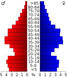 Alterspyramide für das Hancock County
Von den 20.718 Haushalten hatten 36,7 Prozent Kinder unter 18 Jahre, die mit ihnen im Haushalt lebten. 67,5 Prozent waren verheiratete, zusammenlebende Paare, 7,4 Prozent waren allein erziehende Mütter und 22,0 Prozent waren keine Familien. 18,8 Prozent waren Singlehaushalte und in 7,6 Prozent lebten Menschen mit 65 Jahren oder darüber. Die Durchschnittshaushaltsgröße betrug 2,65 und die durchschnittliche Familiengröße lag bei 3,02 Personen.
26,5 Prozent der Bevölkerung waren unter 18 Jahre alt, 6,8 Prozent zwischen 18 und 24, 30,0 Prozent zwischen 25 und 44 Jahre. 25,4 Prozent zwischen 45 und 64 und 11,2 Prozent waren 65 Jahre alt oder älter. Das Durchschnittsalter betrug 37 Jahre. Auf 100 weibliche Personen kamen 97,5 männliche Personen. Auf 100 Frauen im Alter von 18 Jahren und darüber kamen 94,5 Männer.
Das jährliche Durchschnittseinkommen eines Haushalts betrug 56.416 USD, das Durchschnittseinkommen der Familien 63.083 USD. Männer hatten ein Durchschnittseinkommen von 44.001 USD, Frauen 28.562 USD. Das Prokopfeinkommen betrug 24.966 USD. 1,9 Prozent der Familien und 3,0 Prozent der Bevölkerung lebten unterhalb der Armutsgrenze. [4]
Siehe auch
Einzelnachweise
- ↑ GNIS-ID: 450357. Abgerufen am 22. Februar 2011 (englisch).
- ↑ U.S. Census Bureau - Census of Population and Housing. Abgerufen am 15. März 2011
- ↑ Auszug aus Census.gov. Abgerufen am 15. Februar 2011
- ↑ Hancock County, Indiana, Datenblatt mit den Ergebnissen der Volkszählung im Jahre 2000 bei factfinder.census.gov.
 Orte in der Indianapolis Metropolitan Area
Städte mit über 20.000 Einwohnern:
Carmel | Fishers | Greenwood | Lawrence | Noblesville | Plainfield | WestfieldStädte mit weniger als 20.000 Einwohnern:
Arcadia | Avon | Bargersville | Beech Grove | Brooklyn | Brownsburg | Cicero | Clermont | Cloverdale | Cumberland | Danville | Edinburgh | Fairland | Fortville | Franklin | Greencastle | Greenfield | Lebanon | Martinsville | McCordsville | Mooresville | Morristown | New Palestine | New Whiteland | Pittsboro | Princes Lakes | Shelbyville | Sheridan | Speedway | Southport | St. Paul | Thorntown | Whiteland | ZionsvilleCountys:
Boone | Brown | Hamilton | Hancock | Hendricks | Johnson | Marion | Morgan | Putnam | Shelby
Wikimedia Foundation.
Schlagen Sie auch in anderen Wörterbüchern nach:
Hancock County, Indiana — Infobox U.S. County county = Hancock County state = Indiana founded year = 1828 founded date = seat wl = Greenfield largest city wl = Greenfield area total sq mi = 307 area total km2 = 794 area land sq mi = 306 area land km2 = 793 area water sq… … Wikipedia
National Register of Historic Places listings in Hancock County, Indiana — Location of Hancock County in Indiana This is a list of the National Register of Historic Places listings in Hancock County, Indiana. This is intended to be a complete list of the properties and districts on the National Register of Historic… … Wikipedia
Brown Township, Hancock County, Indiana — Infobox Settlement official name = Brown Township settlement type = Township nickname = motto = imagesize = image caption = image imagesize = image caption = image mapsize = map caption = Location in Hancock County mapsize1 = map caption1 =… … Wikipedia
Nashville, Hancock County, Indiana — Nashville Town … Wikipedia
Vernon Township, Hancock County, Indiana — Infobox Settlement official name = Vernon Township settlement type = Township nickname = motto = imagesize = image caption = image imagesize = image caption = image mapsize = map caption = Location in Hancock County mapsize1 = map caption1 =… … Wikipedia
Green Township, Hancock County, Indiana — Infobox Settlement official name = Green Township settlement type = Township nickname = motto = imagesize = image caption = image imagesize = image caption = image mapsize = map caption = Location in Hancock County mapsize1 = map caption1 =… … Wikipedia
Brandywine Township, Hancock County, Indiana — Infobox Settlement official name = Brandywine Township settlement type = Township nickname = motto = imagesize = image caption = image imagesize = image caption = image mapsize = map caption = Location in Hancock County mapsize1 = map caption1 =… … Wikipedia
Sugar Creek Township, Hancock County, Indiana — Infobox Settlement official name = Sugar Creek Township settlement type = Township nickname = motto = imagesize = image caption = image imagesize = image caption = image mapsize = map caption = Location in Hancock County mapsize1 = map caption1 … Wikipedia
Blue River Township, Hancock County, Indiana — Infobox Settlement official name = Blue River Township settlement type = Township nickname = motto = imagesize = image caption = image imagesize = image caption = image mapsize = map caption = Location in Hancock County mapsize1 = map caption1 =… … Wikipedia
Buck Creek Township, Hancock County, Indiana — Infobox Settlement official name = Buck Creek Township settlement type = Township nickname = motto = imagesize = image caption = image imagesize = image caption = image mapsize = map caption = Location in Hancock County mapsize1 = map caption1 =… … Wikipedia
Hancock County (Indiana)


18+
© Academic, 2000-2026
- Kontaktieren Sie uns: Unterstützung, Werbung
Wörterbücher Export, schritte mit PHP, Joomla, Drupal, WordPress, MODx.