International Hydrographic Organization

International Hydrographic Organization
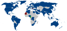
Mitgliedsstaaten der IHO

Die Internationale Hydrographische Organisationthe International Hydrographic Organization (IHO)wurde 1921 als ständige Einrichtung unter dem Namen International Hydrographic Bureau (IHB) von 19 Staaten gegründet. Auf Einladung des seefahrts- und forschungsbegeisterten Prinzen Albert I. wurde der Sitz in Monaco eingerichtet. Die jetzige Bezeichnung besteht seit 1970, IHB bezeichnet seither das in Monaco eingerichtete Sekretariat der Organisation.

Die IHO hat im Jahr 2006 74 Mitgliedsstaaten, deren Repräsentanten (die Leiter der nationalen hydrographischen Institutionen) sich in Fünfjahresabständen zu Internationalen Hydrographischen Konferenzen in Monaco treffen.

Publikationen der IHO werden in Englisch und Französisch, manche auch in Spanisch aufgelegt.

Zielsetzung

  • Koordination der Aktivitäten nationaler hydrographischer Institutionen
  • Schaffung von Normen für die möglichst einheitliche Erstellung nautischer Dokumente und Seekarten (einschließlich elektronischer Ausgaben)
  • Entwicklung und Optimierung zuverlässiger hydrographischer Forschungsmethoden
  • Wissenschaftliche Weiterentwicklung der Ozeanografie.

INT

INT bezeichnet Seekarten, die gemäß dem Normungsvorschlag der Publikation M-4 der IHO gestaltet wurden. Dieser enthält Vorgaben für Farbgebung, Kartenzeichen, Beschriftung (Nomenklatur) von Seekarten und ermöglicht die Nutzung von Ausgaben beliebiger hydrographischer Institute nebeneinander. Karten, die diesem Standard entsprechen, sind am violetten Aufdruck INT…(gefolgt von der internationalen Identifikationsnummer des Werkes) am oberen und unteren Kartenrand kenntlich.

Die Idee zu einem die gesamte Welt abdeckenden INT-Seekartensatz wurde 1971 aufgegriffen. Vollständig umgesetzt ist die Idee bisher für kleinmaßstäbige Karten (1:10.000.000 und 1:3.500.000), INT-Karten in größeren Maßstäben existieren bereits für sehr viele Seegebiete.

Die deutsche Karte 1 (INT 1) enthält sämtliche in internationalen Karten des Bundesamtes für Seeschifffahrt und Hydrographie (BSH) verwendeten Zeichen und Abkürzungen, darüber hinaus auch alle, die in vom BSH herausgegebenen nationalen Karten Anwendung finden.

Weblinks


Wikimedia Foundation.

Игры ⚽ Поможем написать курсовую

Schlagen Sie auch in anderen Wörterbüchern nach:

  • International Hydrographic Organization —   [ɪntə næʃnl haɪdrəʊ græfɪk ɔːgənaɪ zeɪʃn], Abkürzung IHO [aɪeɪtʃ əʊ], deutsch Internationale Hydrographische Organisation, 1921 als International Hydrographic Bureau (Internationales Hydrographisches Büro) in Monaco gegründetes internationales… …   Universal-Lexikon

  • International Hydrographic Organization — IHO redirects here. For other uses, see IHO (disambiguation). International Hydrographic Organization Organisation hydrographique internationale (French) …   Wikipedia

  • Convention on the International Hydrographic Organization — In the 1967 Convention on the International Hydrographic Organization, the International Hydrographic Bureau was reinstituted as an intergovernmental organization, the International Hydrographic Organization.[1] References ^ …   Wikipedia

  • International Maritime Organization — International Maritime Organization …   Wikipedia

  • International Hydrographic Organisation — Mitgliedsstaaten der IHO Die Internationale Hydrographische Organisation – the International Hydrographic Organization (IHO) – wurde 1921 als ständige Einrichtung unter dem Namen International Hydrographic Bureau (IHB) von 19 Staaten gegründet.… …   Deutsch Wikipedia

  • Hydrographic office — A hydrographic office is an organization which is devoted to acquiring and publishing hydrographic information.Historically, the main tasks of hydrographic offices were the conduction of hydrographic surveys and the publication of nautical charts …   Wikipedia

  • Hydrographic survey — Private Survey Ship Neptune Hydrographic survey is the science of measurement and description of features which affect maritime navigation, marine construction, dredging, offshore oil exploration/drilling and related disciplines. Strong emphasis… …   Wikipedia

  • International Association of Lighthouse Authorities — The International Association of Marine Aids to Navigation and Lighthouse Authorities (or IALA for short) is a non profit organization founded in 1957 to collect and provide nautical expertise and advice. Background The International Association… …   Wikipedia

  • International Hydrographische Konferenz — Mitgliedsstaaten der IHO Die Internationale Hydrographische Organisation – the International Hydrographic Organization (IHO) – wurde 1921 als ständige Einrichtung unter dem Namen International Hydrographic Bureau (IHB) von 19 Staaten gegründet.… …   Deutsch Wikipedia

  • Canadian Hydrographic Service — logo or crest The Canadian Hydrographic Service (CHS) is Canada s hydrographic office, with responsibility for performing hydrographic surveys and publishing paper and electronic nautical charts. CHS also represents Canada in the International… …   Wikipedia

Share the article and excerpts

Direct link
https://de-academic.com/dic.nsf/dewiki/660014 Do a right-click on the link above
and select “Copy Link”