- Interstate 86 (West)
-
Basisdaten Länge: 63 mi/101 km Bundesstaat: Idaho Karte  Verlauf
1 Declo  I-84
I-84  US 30
US 30
15 Raft River Area 21 Coldwater Area 28 Massacre Rocks State Park 33 Neeley Area 36  ID 37 American Falls
40  ID 39 American Falls
44 Seagull Bay 49 Rainbow Road 52 Arbon Valley 56 Pocatello Regional Airport 58 US 30 Pocatello61  US 91 Yellowstone Avenue
63 Chubbuck  I-15
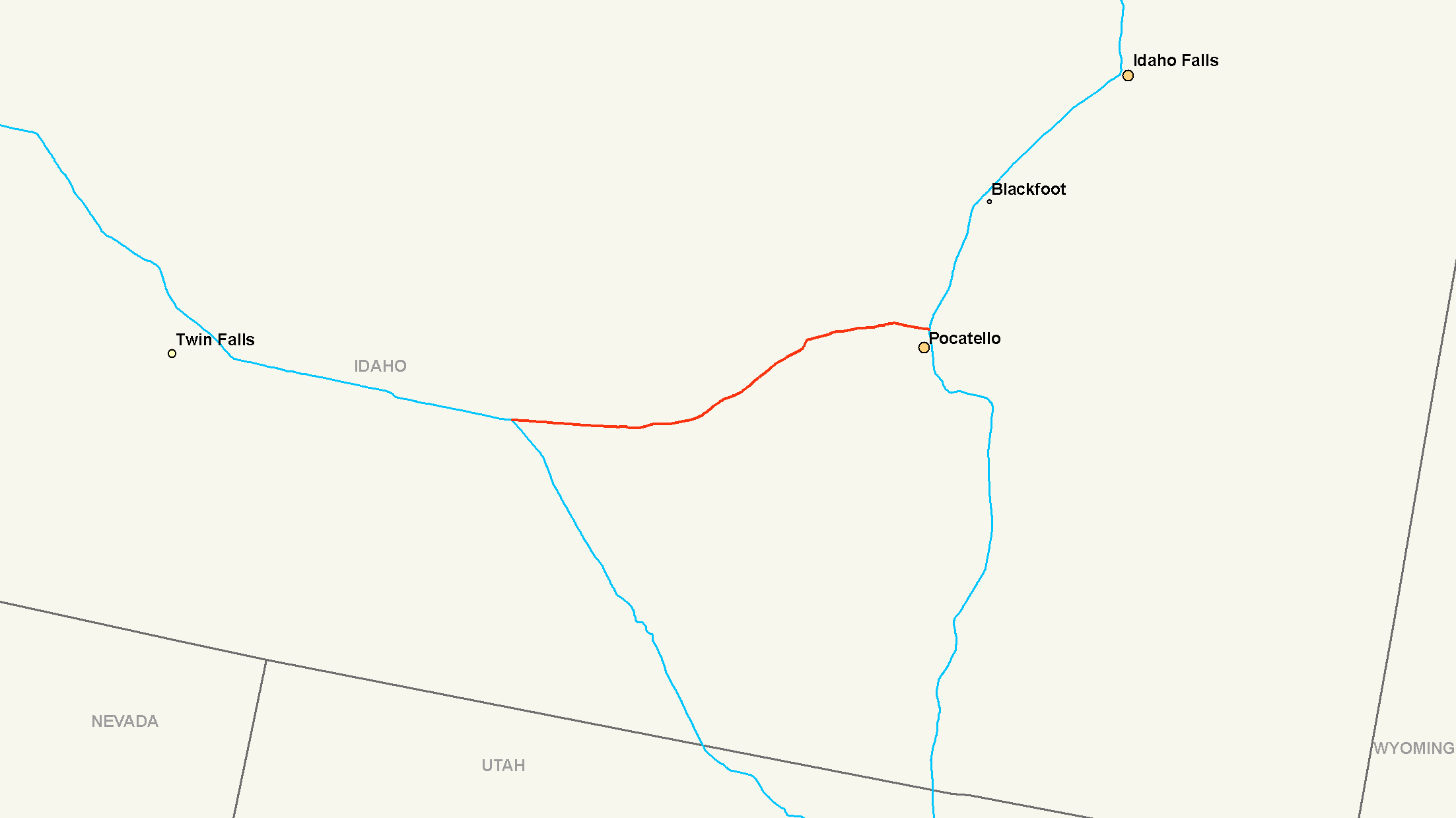
I-15Die Interstate 86 (kurz I-86) ist ein Interstate Highway in den Vereinigten Staaten. Sie verbindet im Bundesstaat Idaho die Interstate 84 nahe Declo mit der Interstate 15 in Chubbuck auf einer Strecke von 101 Kilometern.
Verlauf
Ab dem Kreuz mit die Interstate 84 nördlich von Declo verläuft sie gemeinsam mit dem U.S. Highway 30 in östlicher Richtung. Die I-86 folgt meist dem Verlauf des Snake Rivers und passiert dabei unter anderem den Massacre Rocks State Park. Im Süden des American Falls Reservoirs auf dem Stadtgebiet von American Falls trifft die Interstate auf die Idaho State Routes 37 und 39. Nachdem die Trasse den Pocatello Regional Airport passiert hat, zweigt der US 30 in südlicher Richtung ab. Nach einem Kreuz mit dem U.S. Highway 91 im Zentrum von Chubbuck endet sie im Osten der Stadt an der Interstate 15.
Weblinks
 Commons: Interstate 86 – Sammlung von Bildern, Videos und Audiodateien
- Interstate Guide (englisch)
- Idaho Transportation Department (englisch)
1 bis 99 4 • 5 • 8 • 10 • 12 • 15 • 16 • 17 • 19 • 20 • 22 • 24 • 25 • 26 • 27 • 29 • 30 • 35 • 37 • 39 • 40 • 43 • 44 • 45 • 49 • 55 • 57 • 59 • 64 • 65 • 66 • 68 • 69 • 70 • 71 • 72 • 73 • 74 • 75 • 76 (West) • 76 (Ost) • 77 • 78 • 79 • 80 • 81 • 82 • 83 • 84 (West) • 84 (Ost) • 85 • 86 (West) • 86 (Ost) • 87 • 88 (West) • 88 (Ost) • 89 • 90 • 91 • 93 • 94 • 95 • 96 • 97 • 99

ab 100 105 (Kalifornien) • 180 (Illinois) • 180 (Nebraska) • 180 (Pennsylvania) • 180 (Wyoming) • 205 (Kalifornien) • 205 (Oregon-Washington) • 235 (Iowa) • 238 • 280 (Illinois-Iowa) • 280 (Kalifornien) • 280 (New Jersey) • 280 (Ohio) • 380 (Iowa) • 380 (Kalifornien) • 380 (Pennsylvania) • 405 (Kalifornien) • 405 (Oregon) • 480 (Iowa-Nebraska) • 480 (Ohio) • 505 (Kalifornien) • 515 • 580 (Kalifornien) • 580 (Nevada) • 710 • 805
Hawaii Alaska A-1 • A-2 • A-3 • A-4
Puerto Rico PR-1 • PR-2 • PR-3
Wikimedia Foundation.
Schlagen Sie auch in anderen Wörterbüchern nach:
Interstate 66 (west) — Infobox road route=66 type=I alternate name= length mi= length round= length ref= year established= direction a= terminus a= junction= direction b= terminus b=The U.S. Department of Transportation has had plans to extend Interstate 66 westward… … Wikipedia
Interstate 84 (west) — Infobox road route=84 route type=reg type=I length mi=770 year established=1966 direction a=West direction b=East length km=1239 terminus a= terminus b= junction= commons=categoryInterstate 84 (I 84) is an interstate highway in the Western United … Wikipedia
Interstate 76 (West) — Basisdaten Länge: 188 mi/303 km Bundesstaaten: Colorado Nebraska … Deutsch Wikipedia
Interstate 88 (West) — Basisdaten Länge: 140 mi/226 km Bundesstaat: Illinois Verlaufsrichtung: Os … Deutsch Wikipedia
Interstate 84 (West) — Basisdaten Länge: 770 mi/1239 km Bundesstaaten: Oregon Idaho Utah … Deutsch Wikipedia
Interstate 76 (west) — For the Interstate 76 that runs through Ohio, Pennsylvania, and New Jersey, see Interstate 76 (east). Interstate 76 … Wikipedia
Interstate 88 (west) — Infobox road state=IL type=I route=88 maint=Illinois DOT alternate name=Ronald Reagan Memorial Freeway, Ronald Reagan Memorial Tollway year established=July 1988cite news |publisher=Chicago Tribune |author=Mehler, Neil H.|date=1987 07 06… … Wikipedia
Interstate 86 (west) — Infobox road state=ID type=I route=86 maint=ITD length mi=62.850 length round=3 length ref= established= direction a=West terminus a=jct|state=ID|I|84|US|30 near Declo junction= direction b=East terminus b=jct|state=ID|I|15 in Pocatello previous… … Wikipedia
The South Carolina Interstate and West Indian Exposition — In 1901 Charleston hosted a World s Fair formally called The South Carolina Interstate and West Indian Exposition. That name was shortened to The West Indian Exposition or The Charleston Exposition. External links*… … Wikipedia
Interstate 84 in Oregon — Interstate 84 Route information … Wikipedia
Interstate 86 (West)


18+
© Academic, 2000-2026
- Kontaktieren Sie uns: Unterstützung, Werbung
Wörterbücher Export, schritte mit PHP, Joomla, Drupal, WordPress, MODx.