Jemez Springs

Jemez Springs
Jemez Springs
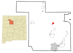
Sandoval County New Mexico Incorporated and Unincorporated areas Jemez Springs Highlighted.svg
Lage in New Mexico
Basisdaten
Staat: Vereinigte Staaten
Bundesstaat: New Mexico
County:

Sandoval County

Koordinaten: 35° 46′ N, 106° 42′ W35.770833333333-106.69251889Koordinaten: 35° 46′ N, 106° 42′ W
Zeitzone: Mountain Standard Time (UTC−7)
Einwohner: 375 (Stand: 2000)
Bevölkerungsdichte: 30,2 Einwohner je km²
Fläche: 12,4 km² (ca. 5 mi²)
davon 12,4 km² (ca. 5 mi²) Land
Höhe: 1889 m
Postleitzahl: 87025
Vorwahl: +1 505
FIPS: 35-35320
GNIS-ID: 0918208

Jemez Springs ist ein Dorf mit 375 Einwohnern im Sandoval County im US-Bundesstaat New Mexico. Die Fläche beträgt 12,4 km². Jemez Springs liegt auch neben dem Jemez State Monument. Nachbargemeinden sind Jemez Pueblo und Ponderosa. Der 3431 Meter hohe Redondo Peak in den Jemez Mountains liegt auch nahe dem Dorf.


Wikimedia Foundation.

Игры ⚽ Поможем написать курсовую

Schlagen Sie auch in anderen Wörterbüchern nach:

  • Jemez Springs — Jemez Springs, NM U.S. village in New Mexico Population (2000): 375 Housing Units (2000): 149 Land area (2000): 4.801994 sq. miles (12.437108 sq. km) Water area (2000): 0.000000 sq. miles (0.000000 sq. km) Total area (2000): 4.801994 sq. miles… …   StarDict's U.S. Gazetteer Places

  • Jemez Springs, NM — U.S. village in New Mexico Population (2000): 375 Housing Units (2000): 149 Land area (2000): 4.801994 sq. miles (12.437108 sq. km) Water area (2000): 0.000000 sq. miles (0.000000 sq. km) Total area (2000): 4.801994 sq. miles (12.437108 sq. km)… …   StarDict's U.S. Gazetteer Places

  • Jémez Springs (Nuevo México) — Jémez Springs Villa de los Estados Unidos …   Wikipedia Español

  • Jemez Springs, New Mexico — Infobox Settlement official name = Jemez Springs, New Mexico settlement type = Village nickname = motto = imagesize = image caption = image imagesize = image caption = image mapsize = 250px map caption = Location of Jemez Springs, New Mexico… …   Wikipedia

  • Jemez State Monument — U.S. National Register of Historic Places …   Wikipedia

  • Jemez Pueblo — Lage in New Me …   Deutsch Wikipedia

  • Jemez Mountains — The Jemez Mountains ( heɪmez) are a group of volcanic mountains in New Mexico, United States. The highest point in the range is Chicoma Mountain (also spelled as Tschicoma or Tchicoma) at an elevation of 11,561 feet (3524 meters). The town of Los …   Wikipedia

  • Sierra de Jémez — La sierra de Jémez[1] es un cordal montañoso formado por un grupo de montañas de origen volcánico en el estado de Nuevo Méjico en los Estados Unidos de América. Su punto más elevado es el cerro de Chicoma con sus 3 524 metros. El pueblo de Los… …   Wikipedia Español

  • 87025 — Jemez Springs, Nm (Miscellaneous » ZIP Codes) …   Abbreviations dictionary

  • National Register of Historic Places listings in Sandoval County, New Mexico — Location of Sandoval County in New Mexico This is a list of the National Register of Historic Places listings in Sandoval County, New Mexico. This is intended to be a complete list of the properties and districts on the National Register of… …   Wikipedia

Share the article and excerpts

Direct link
Do a right-click on the link above
and select “Copy Link”