- Amphoe Thai Mueang
-
Thai Mueang
ท้ายเหมืองProvinz: Phangnga Fläche: 611,8 km² Einwohner: 45.547 (2000) Bev.dichte: 74,4 E./km² PLZ: 82120 Geocode: 8208 Karte 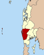
Thai Mueang (Thai: ท้ายเหมือง) ist ein Landkreis (Amphoe - Verwaltungs-Distrikt) in der Provinz Phangnga in Südthailand.
Inhaltsverzeichnis
Geographie
Benachbarte Landkreise und Gebiete sind (von Norden im Uhrzeigersinn): Amphoe Takua Pa, Amphoe Kapong, Amphoe Mueang Phang Nga und Amphoe Takua Thung. Im Westen liegt die Andamanensee.
Sehenswürdigkeiten
- Der 72 km² große Nationalpark „Khao Lampi - Hat Thai Mueang“ wurde 1986 eingerichtet. Der Park besteht aus zwei Teilen, dem Strand von Thai Mueang sowie dem natürlichen Regenwald in den Lampi Bergen.
- Die Similan-Inseln sind über die Hafenstadt Thap Lamu im Tambon Lam Kaen erreichbar.
Verwaltung
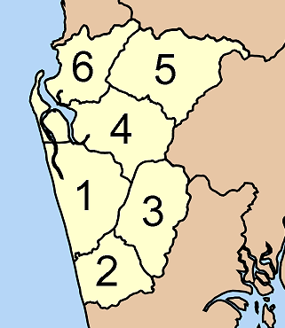
Amphoe Thai Mueang ist in sechs Unterbezirke (Tambon) eingeteilt, welche weiter in 40 Dorfgemeinschaften (Mubaan) unterteilt sind.
Thai Mueang ist auch der Name einer Kleinstadt (Thesaban Tambon) im Landkreis, sie besteht aus Teilen des Tambon Thai Mueang.
Außerdem gibt es sechs „Tambon Administrative Organizations“ (TAO, องค์การบริหารส่วนตำบล – Verwaltungs-Organisationen) im Landkreis.
Nr. Name Thai Dörfer Einw. 1. Thai Mueang ท้ายเหมือง 9 11.172 2. Na Toei นาเตย 9 8.919 3. Bang Thong บางทอง 7 5.075 4. Thung Maphrao ทุ่งมะพร้าว 11 8.908 5. Lam Phi ลำภี 7 4.827 6. Lam Kaen ลำแก่น 6 6.646 
Weblinks
- Weitere Informationen zum Amphoe Thai Mueang von der Phang-Nga-Provinzverwaltung (in Thai)
- Offizielle Seite des Nationalparks Khao Lampi-Hat Thai Mueang

Mueang Phangnga | Kapong | Khura Buri | Ko Yao | Takua Pa | Takua Thung | Thap Put | Thai Mueang
Wikimedia Foundation.
Schlagen Sie auch in anderen Wörterbüchern nach:
Amphoe Thai Mueang — Admin ASC 2 Code Orig. name Amphoe Thai Mueang Country and Admin Code TH.61.1150316 TH … World countries Adminstrative division ASC I-II
Amphoe Thai Mueang — Infobox Amphoe name=Thai Mueang thai=ท้ายเหมือง province=Phang Nga coordinates=coord|8|24|0|N|98|15|42|E|type:adm2nd region:TH area=611.8 population=45,547 population as of=2000 density=74.4 postal code=82120 geocode=8208Thai Mueang ( th.… … Wikipedia
Amphoe Khu Mueang — Khu Mueang คูเมือง Provinz: Buriram Fläche: 442,0 km² Einwohner: 66.839 (2005) Bev.dichte: 151,2 E./km² PLZ: 31190 … Deutsch Wikipedia
Amphoe Thai Charoen — Thai Charoen ไทยเจริญ Provinz: Yasothon Fläche: 272,02 km² Einwohner: 29.842 (2005) Bev.dichte: 109,7 E./km² PLZ: 35120 … Deutsch Wikipedia
Amphoe Si Mueang Mai — Si Mueang Mai ศรีเมืองใหม่ Provinz: Ubon Ratchathani Fläche: 1310,0 km² Einwohner: 65.443 (2005) Bev.dichte: 50,0 E./km² PLZ … Deutsch Wikipedia
Amphoe Thai Charoen — Infobox Amphoe name=Thai Charoen thai=ไทยเจริญ province=Yasothon coordinates=coord|16|3|47|N|104|26|50|E|type:adm2nd region:TH capital=Thai Charoen area=272.02 population=29,842 population as of=2005 density=109.7 postal code=35120… … Wikipedia
Thai Mueang — Original name in latin Thai Mueang Name in other language Amphoe Dhaihmoeang, Amphoe Thai Muang, Ban Dhai Hmoeang, Ban Thai Muang, Dhai Hmoeang, Tai Muang, Thai Muang, Thai Mueang, thayhemuxng State code TH Continent/City Asia/Bangkok longitude 8 … Cities with a population over 1000 database
Amphoe Khu Mueang — Infobox Amphoe name=Khu Mueang thai=คูเมือง province=Buriram coordinates=coord|15|16|18|N|103|0|6|E|type:adm2nd region:TH capital=Khu Mueang area=442.0 population=66,839 population as of=2005 density=151.2 postal code=31190 geocode=3102Khu Mueang … Wikipedia
Amphoe Si Mueang Mai — Infobox Amphoe name=Si Mueang Mai thai=ศรีเมืองใหม่ province=Ubon Ratchathani coordinates=coord|15|29|43|N|105|16|43|E|type:adm2nd region:TH capital=Na Kham area=1,310.0 population=65,443 population as of=2005 density=50.0 postal code=34250… … Wikipedia
Amphoe Takua Thung — Takua Thung ตะกั่วทุ่ง Provinz: Phangnga Fläche: 610,8 km² Einwohner: 40.392 (2005) Bev.dichte: 66,1 E./km² PLZ: 82130 … Deutsch Wikipedia
Amphoe Thai Mueang


18+
© Academic, 2000-2026
- Kontaktieren Sie uns: Unterstützung, Werbung
Wörterbücher Export, schritte mit PHP, Joomla, Drupal, WordPress, MODx.