- Anacostia River
-
Anacostia River 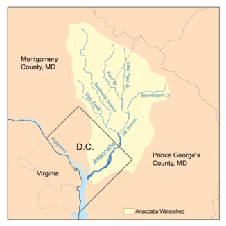
Daten Lage Maryland, District of Columbia; USA Flusssystem Potomac Abfluss über Potomac → Chesapeake Bay Quelle Zusammenfluss Northeast Branch und Northwest Branch
38° 56′ 33″ N, 76° 56′ 38″ W38.9425-76.943888888889Mündung in Washington, D.C. in den Potomac River 38.853611111111-77.020277777778Koordinaten: 38° 51′ 13″ N, 77° 1′ 13″ W
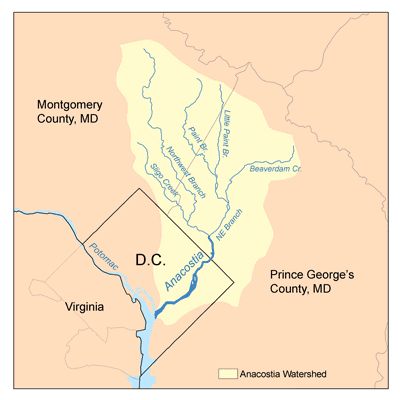
38° 51′ 13″ N, 77° 1′ 13″ W38.853611111111-77.020277777778Länge 13,5 km Der Anacostia River ist ein Fluss in den Vereinigten Staaten, der auch die Hauptstadt Washington, D.C. durchfließt und dort in den Potomac River mündet. Er hat eine Länge von 13,5 km und entspringt im Prince George’s County in Maryland. Umweltverschmutzung und wenig Investition trugen dazu bei, dass der Fluss unansehnlich wurde. Er erhielt so seinen Spitznamen "D.C.’s forgotten river" also D.C.s vergessener Fluss. Am Fluss befindet sich der Washington Navy Yard sowie das Hauptquartier des Naval Criminal Investigative Service.
Namensvarianten
Der Fluss besitzt mehrere Bezeichnungsvarianten:
- Annacostin River[1]
- Annacostone River[2]
- Annakostia River[3]
- East Branch[4]
- Eastern Branch[5]
- Eastern Branch of the Potomac[6]
Einzelnachweise
- ↑ Kenny, Hamill. The Placenames of Maryland, Their Origin and Meaning. Baltimore: Museum and Library of Maryland History, Maryland Historical Society, 1984. The origin and meaning of the various words and phrases used in Maryland to name the State's most representative villages, towns, cities, mountains, and watercourses. Copious footnotes and an extensive bibliography. Superior treatment of Indian-derived placenames. p28
- ↑ Bryan, Wilhelmus Bogart. A History of the National Capital from Its Foundation through the Period of the Adoption of the Organic Act. Macmillan Co., 1914. I/53/1663
- ↑ Dermott/City of Washington map/1797
- ↑ Cram, George F. Map of Washington. Chicago: Phillips and Hunt, 1891. Page 183 in People's Atlas. Size 9x11.5. Prominent downtown buildings named in separate key. Compiled as part of a railway system atlas. 1891
- ↑ U.S. Geological Survey. Geographic Names Phase I data compilation (1976-1981). 31-Dec-1981. Primarily from U.S. Geological Survey 1:24,000-scale topographic maps (or 1:25K, Puerto Rico 1:20K) and from U.S. Board on Geographic Names files. In some instances, from 1:62,500 scale or 1:250,000 scale maps
- ↑ J T Dubois map/1892
Weblinks
-
 Commons: Anacostia River – Sammlung von Bildern, Videos und Audiodateien
 - Anacostia River im Geographic Names Information System des United States Geological Survey
Kategorien:- Flusssystem Potomac River
- Verkehr (Washington, D.C.)
- Geographie (Washington, D.C.)
- Fluss in Maryland
- Fluss in Nordamerika
Wikimedia Foundation.