- Potomac River
-
Potomac River
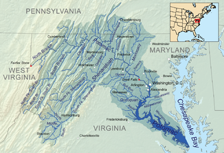
CohongorootonDas Einzugsgebiet des Potomacs umfasst vier Bundesstaaten und Washington, D.C.
Daten Lage West Virginia, Maryland, Virginia, District of Columbia, Vereinigte Staaten Flusssystem Potomac River Quelle Fairfax Stone, Preston County, West Virginia
39° 11′ 43″ N, 79° 29′ 28″ W39.195277777778-79.491111111111933Quellhöhe 933 m Mündung Chesapeake Bay, Maryland, Virginia 37.999166666667-76.2497222222220Koordinaten: 37° 59′ 57″ N, 76° 14′ 59″ W
37° 59′ 57″ N, 76° 14′ 59″ W37.999166666667-76.2497222222220Mündungshöhe 0 m Höhenunterschied 933 m Länge 616 km Einzugsgebiet 6.053 km² Abflussmenge
am Pegel Washington, D.C.NNQ: 1,9 m³/s (im Jahr 2008)
MQ: 316 m³/s
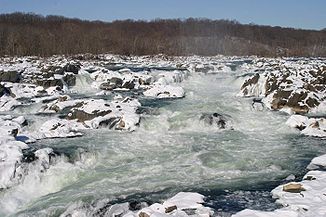
HHQ: 12.000 m³/s (im Jahr 1936)Rechte Nebenflüsse Shenandoah Linke Nebenflüsse Antietam, Monocacy Großstädte Washington, D.C. Mittelstädte Harpers Ferry, WV, Arlington, VA, Alexandria, VA Great Falls of the Potomac River im Winter
Der Potomac [pəˈtoʊmək] ist ein Fluss im Osten der USA, der von seinem Ursprung in West Virginia nach etwa 616 km in die Chesapeake Bay mündet.
Seine beiden Quellflüsse vereinigen sich bei Cumberland im westlichen Maryland. Der Fluss bildet in seinem Verlauf Teile der natürlichen Grenzen zwischen Maryland, West Virginia, Virginia und dem District of Columbia. Bevor er in die Chesapeake Bay mündet, erreicht der Fluss eine Breite von fünf bis sieben Meilen.
Während des Sezessionskriegs kam dem Wasserlauf aufgrund des häufig wechselnden Frontverlaufes eine wichtige Rolle bei den Operationen beider Heere zu. Die größte Armee der Union bekam aufgrund ihres Einsatzgebietes den Namen Potomac-Armee.
Nach dem Potomac ist der Asteroid (1345) Potomac benannt, der 1908 von J. H. Metcalf entdeckt wurde.
Potomac bezeichnet zudem einen Stamm der mächtigen Powhatan-Föderation, der es gelang, etwa 30 bis 40 Algonkin-Stämme zusammenzuschließen.
Außerdem ist Potomac der Name einer am Fluss Potomac gelegenen Ortschaft in Montgomery County, etwa 20 Kilometer von Washington, D.C. entfernt. Beim Ort Potomac befinden sich die großen Wasserfälle des Potomac Rivers.
Hydrologie
Der United States Geological Survey betreibt in Washington, D.C. einen Pegel. Dort beträgt die jährliche mittlere Abflussmenge 316 m³/s. Der höchste je gemessene Wert war 3944 m³/s., der niedrigste wurde am 17. Februar 2008 mit 1,9 m³/s beobachtet.
-
Oberlauf des Potomacs
-
Das Pentagon nahe Washington (D.C.), im Hintergrund der Potomac
-
Karte des Einzugsgebiets des Flusses
Weblink
 Commons: Potomac River – Album mit Bildern und/oder Videos und AudiodateienKategorien:
- Flusssystem Potomac River
- Verkehr (Washington, D.C.)
- Geographie (Washington, D.C.)
- Fluss in West Virginia
- Fluss in Virginia
- Fluss in Maryland
- Fluss in Nordamerika
- American Heritage Rivers
-
Wikimedia Foundation.


