- Katsuyama
-
Katsuyama-shi
勝山市Geographische Lage in Japan Region: Chūbu Präfektur: Fukui Koordinaten: 36° 4′ N, 136° 30′ O36.060833333333136.50055555556Koordinaten: 36° 3′ 39″ N, 136° 30′ 2″ O Basisdaten Fläche: 253,68 km² Einwohner: 25.218
(1. Juli 2011)Bevölkerungsdichte: 99 Einwohner je km² Gemeindeschlüssel: 18206-1 Symbole Baum: Kiefer Blume: Rhododendron indicum Rathaus Adresse: Katsuyama City Hall
1-1-1, Moto-machi
Katsuyama-shi
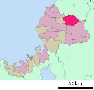
Fukui 911-8501Webadresse: http://www.city.katsuyama.fukui.jp Lage Katsuyamas in der Präfektur Fukui Katsuyama (jap. 勝山市, -shi) ist eine japanische Stadt in der Präfektur Fukui.
Inhaltsverzeichnis
Geschichte
Die Stadt Katsuyama wurde am 1. September 1954 gegründet.
Geographie
Katsuyama liegt südlich von Kanazawa und nördlich von Fukui.
Städtepartnerschaften
Verkehr
- Straße:
- Hokuriku-Autobahn
- Nationalstraße 157, 416
- Zug:
- JR Hokuriku-Hauptlinie, Bahnhof Katsuyama, nach Maibara und Joetsu
- Echizen Katsuyama-Eiheiji-Linie
Angrenzende Städte und Gemeinden
Weblinks
Commons: Katsuyama – Sammlung von Bildern, Videos und AudiodateienGemeinden und Landkreise in der Präfektur FukuiKreisfreie Städte (shi): Awara | Echizen | Fukui (Verwaltungssitz) | Katsuyama | Obama | Ōno | Sabae | Sakai | Tsuruga
Imadate-gun: Ikeda | Mikata-gun: Mihama | Mikata-Kaminaka-gun: Wakasa | Nanjō-gun: Minami-Echizen | Nyū-gun: Echizen | Ōi-gun: Ōi | Takahama | Yoshida-gun: Eiheiji
Wikimedia Foundation.
Schlagen Sie auch in anderen Wörterbüchern nach:
Katsuyama — shi (勝山市) Musée paléontologique de la préfecture de Fukui à Katsuyama Administration Pays Japon Région … Wikipédia en Français
Katsuyama — Original name in latin Katsuyama Name in other language State code JP Continent/City Asia/Tokyo longitude 36.06173 latitude 136.50101 altitude 130 Population 27088 Date 2008 10 25 … Cities with a population over 1000 database
Katsuyama (Fukuoka) — Katsuyama machi (eingemeindet) 勝山町 … Deutsch Wikipedia
Katsuyama (Begriffsklärung) — Katsuyama bezeichnet: eine ehemalige Stadt in der Präfektur Fukuoka: Katsuyama (Fukuoka) (heute: Miyako (Fukuoka)) eine ehemalige Stadt in der Präfektur Okayama: Katsuyama (Okayama) (heute: Maniwa) folgende Lehen (han): in der Provinz Awa:… … Deutsch Wikipedia
Katsuyama, Okayama — nihongo|Katsuyama|勝山町|Katsuyama chō was a town located in Maniwa District, Okayama, Japan. On March 31, 2005, Katsuyama and several nearby municipalities merged to form the new city of Maniwa.In 2003 the town had an estimated population of 9,027… … Wikipedia
Katsuyama Eiheiji Line — nihongo|Katsuyama Eiheiji Line|勝山永平寺線|Katsuyama Eiheiji sen is a railway line operated by Echizen Railway in Fukui Prefecture. The line streches from the city of Fukui to Katsuyama with a total of 27.8 km and 23 stations. It was operated by… … Wikipedia
Katsuyama, Fukui — nihongo|Katsuyama|勝山市|Katsuyama shi is a city located in Fukui, Japan.As of October 1 2005, the city has an estimated population of 26,961 and the density of 106.28 persons per km². The total area is 253.68 km².The city was founded on September 1 … Wikipedia
Katsuyama, Fukuoka — was a town located in Miyako District, Fukuoka, Japan. On March 20, 2006, Katsuyama merged with the towns of Saigawa and Toyotsu to form the new town of Miyako.As of 2003, the town had an estimated population of 7,319 and a density of 215.65… … Wikipedia
Katsuyama-shi — Admin ASC 2 Code Orig. name Katsuyama shi Country and Admin Code JP.06.1859762 JP … World countries Adminstrative division ASC I-II
Chūgoku-Katsuyama Station — 中国勝山駅 Chūgoku Katsuyama Station, January 2008 Location Prefectu … Wikipedia
- Straße: