- Kyōtanabe
-
Kyōtanabe-shi
京田辺市Geographische Lage in Japan Region: Kinki Präfektur: Kyōto Koordinaten: 34° 49′ N, 135° 46′ O34.814166666667135.76777777778Koordinaten: 34° 48′ 51″ N, 135° 46′ 4″ O Basisdaten Fläche: 42,94 km² Einwohner: 68.311
(1. Juli 2011)Bevölkerungsdichte: 1.591 Einwohner je km² Gemeindeschlüssel: 26211-1 Rathaus Adresse: Kyōtanabe City Hall
80 Tanabe
Kyōtanabe-shi
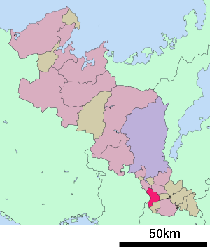
Kyōto 610-0393Webadresse: http://www.kyotanabe.jp Lage Kyōtanabes in der Präfektur Kyōto 
Kyōtanabe (jap. 京田辺市, -shi) ist eine japanische Stadt im Norden der Präfektur Kyōto.
Inhaltsverzeichnis
Geographie
Kyōtanabe liegt südlich von Kyōto und nördlich von Nara.
Geschichte
Die Stadt Kyōtanabe wurde am 1. April 1997 gegründet.
Verkehr
- Straße
- Nationalstraße 1, Richtung Tokio oder Ōsaka
- Nationalstraße 24,397
- Zug
Angrenzende Städte und Gemeinden
- Präfektur Kyōto
- Präfektur Ōsaka
- Präfektur Nara
Weblinks
- Offizielle Website (japanisch)
Kreisfreie Städte (shi): Ayabe | Fukuchiyama | Jōyō | Kameoka | Kizugawa | Kyōtanabe | Kyōtango | Kyōto (Verwaltungssitz) | Maizuru | Miyazu | Mukō | Nagaokakyō | Nantan | Uji | Yawata
Funai-gun: Kyōtamba | Kuse-gun: Kumiyama | Otokuni-gun: Ōyamazaki | Sōraku-gun: Kasagi | Minamiyamashiro | Seika | Wazuka | Tsuzuki-gun: Ide | Ujitawara | Yosa-gun: Ine | Yosano
- Straße
Wikimedia Foundation.


