LC-17B

LC-17B
CCAFS LC-17
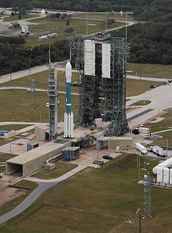
Blick auf Startplatz 17B
Koordinaten 28° 26′ 47″ N, 80° 33′ 55″ W28.4465-80.56527Koordinaten: 28° 26′ 47″ N, 80° 33′ 55″ W
Typ Orbital Launch Site
Betreiber US Air Force / NASA
Baubeginn 1956
Launch Pads 2 (17A, 17B)
Min. Inklination 28 °
Max. Inklination 57 °
Raketen Thor, Delta
Erster Start 26. Januar 1957
Starts insgesamt 319
Status aktiv
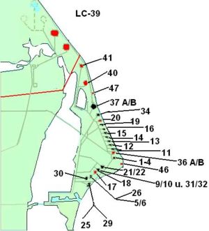
CCAFS LC-39 Kennedy Space Center Launch Complex 39 LC-41 Cape Canaveral AFS Launch Complex 41 LC-40 Cape Canaveral AFS Launch Complex 40 LC-47 Cape Canaveral AFS Launch Complex 47 LC-37 Cape Canaveral AFS Launch Complex 37 LC-34 Cape Canaveral AFS Launch Complex 34 LC-20 Cape Canaveral AFS Launch Complex 20 LC-19 Cape Canaveral AFS Launch Complex 19 LC-16 Cape Canaveral AFS Launch Complex 16 LC-15 Cape Canaveral AFS Launch Complex 15 LC-14 Cape Canaveral AFS Launch Complex 14 LC-13 Cape Canaveral AFS Launch Complex 13 LC-12 Cape Canaveral AFS Launch Complex 12 LC-11 Cape Canaveral AFS Launch Complex 11 LC-36 Cape Canaveral AFS Launch Complex 36 LC-46 Cape Canaveral AFS Launch Complex 46 Cape Canaveral AFS Launch Complex 21 Cape Canaveral AFS Launch Complex 22 Cape Canaveral AFS Launch Complex 9 Cape Canaveral AFS Launch Complex 10 Cape Canaveral AFS Launch Complex 31 Cape Canaveral AFS Launch Complex 32 LC-18 Cape Canaveral AFS Launch Complex 18 LC-22 LC-17 Cape Canaveral AFS Launch Complex 17 LC-26 Cape Canaveral AFS Launch Complex 26 Cape Canaveral AFS Launch Complex 5 Cape Canaveral AFS Launch Complex 6 LC-29 Cape Canaveral AFS Launch Complex 29 Cape Canaveral AFS Launch Complex 25 LC-30 Cape Canaveral AFS Launch Complex 30
Über dieses Bild

Cape Canaveral AFS Launch Complex 17 (LC-17) ist ein aktiver Startkomplex der Cape Canaveral Air Force Station auf Merritt Island, Cape Canaveral in Florida, USA und besteht aus den beiden Startrampen LC-17A und LC-17B.

Mit über 300 Raketenstarts seit Ende der 1950er Jahre ist LC-17 der mit Abstand meistgenutzte Startkomplex auf Cape Canaveral.

Inhaltsverzeichnis

Geschichte

Ursprünglich wurde dieser Startplatz 1956 für das Erprobungsprogramm der Thor-Mittelstreckenrakete gebaut. Der erste Start fand 1957 von Pad 17B statt und scheiterte.

Bis in die 1960er Jahre starteten verschiedene Thor Versionen von Launch Complex 17. Außerdem kam in den 1960ern die zivile, von der Thor abgeleitete, Delta-Rakete hinzu. 1965 wurde der Startplatz von der USAF an die NASA übergeben, da er fast nur noch zivil genutzt wurde. 1988 wurde Startplatz 17 jedoch, wahrscheinlich wegen des Beginns der großen Zahl von Delta-Starts, mit den militärischen GPS-Navigationssatelliten an die US-Luftwaffe zurückgegeben. 1996 wurden die bisher rot gestrichenen Montage- und Starttürme in Grau lackiert.

Heute wird Startkomplex 17 für den Start von Delta-II-Raketen genutzt.

Der Komplex

Startkomplex 17. Startplatz 17A (Vordergrund) und 17B mit Delta II 7925-10C Rakete

Der Komplex besteht aus zwei Startrampen: 17A und 17B. Beides sind Betonstarttische mit einem Flammablenkkanal, auf dem sich ein Metall-Startturm befindet. Zu den Startplätzen gehört jeweils ein fahrbares Metallgerüst, der Montageturm, der dazu dient, die Raketen auf dem Starttisch zusammenzusetzen. Ist die Rakete montiert, entfernt er sich vom Starttisch, und die Rakete wird gestartet. Startplatz 17B wurde zwischenzeitlich umgebaut und kann nun auch (im Gegensatz zu Startplatz 17A) die Delta II Heavy und Delta III mit ihren größeren Feststoffboostern starten.[1]


Startliste

Siehe: Liste aller Starts vom Launch Complex 17

Einzelnachweise

  1. http://marsrovers.jpl.nasa.gov/mission/launch_differences.html

Weblinks


Wikimedia Foundation.

Игры ⚽ Поможем сделать НИР

Schlagen Sie auch in anderen Wörterbüchern nach:

  • New York State Route 17B — NYS Route 17B Route information Auxiliary route of NY 17 Maintained by NYSDOT and Sullivan County …   Wikipedia

  • Ontario Highway 17B — Highway 17B was formerly the highway designation for five business routes of Highway 17, the main route of the Trans Canada Highway through the Canadian province of Ontario. Each was the original route of Highway 17 through the town or city that… …   Wikipedia

  • Highway 17B (Ontario) — Highway 17B was formerly the highway designation for five business routes of Highway 17, the main route of the Trans Canada Highway through the Canadian province of Ontario. Each was the original route of Highway 17 through the town or city that… …   Wikipedia

  • D-17B — Autonetics D 17 guidance computer from a Minuteman I missile. The D 17B is a computer used in missile guidance systems, specifically the Minuteman I NS 1OQ missile guidance system, which contains a D 17B computer, the associated stable platform,… …   Wikipedia

  • New York State Route 17B — Karte …   Deutsch Wikipedia

  • SB 17b — SB 17a,b,c,d / KsOd I / BBÖ 103 / BBÖ 403 / BBÖ 503 / BBÖ 603 / ČSD 253.1 / SHS/JDŽ 103 / DSA/MÁV 226 / FS 542 …   Deutsch Wikipedia

  • WASP-17b — Tailles comparées de Jupiter et de WASP 17b. Étoile Nom WASP 17 Ascension droite 15h 59m 51s …   Wikipédia en Français

  • WASP-17b — Экзопланета Список экзопланетных систем Сравнение размеров WASP 17b с Юпитером. Родительская звезда …   Википедия

  • National Highway 17B (India) — 17B …   Wikipedia

  • WASP-17b — Comparación de tamaño de WASP 17b con Júpiter. Descubrimiento Descubridor David R. Anderson et al …   Wikipedia Español

Share the article and excerpts

Direct link
Do a right-click on the link above
and select “Copy Link”