- London Borough of Enfield
-
London Borough of Enfield 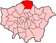
Lage in Greater LondonStatus London Borough Region Greater London Verwaltungssitz Enfield Town Fläche 82,20 km² (236.) Einwohner (2008) 287.600 (30.) ONS-Code 00AK Website www.enfield.gov.uk Der London Borough of Enfield [ˈɛnfiːld] ist der am nördlichsten gelegene Stadtbezirk von London.
Inhaltsverzeichnis
Geschichte
Bei der Gründung der Verwaltungsregion Greater London im Jahr 1965 entstand er aus dem Municipal Borough of Southgate, dem Municipal Borough of Enfield und dem Municipal Borough of Edmonton in der Grafschaft Middlesex.
Im Jahr 2008 zählte der 82,20 km² große Bezirk 287.600 Einwohner, die Bevölkerungsdichte betrug 3.499 Einwohner je km². Die Bevölkerung setzte sich zusammen aus 70,9 % Weißen, 9,2 % Asiaten, 13,5 % Schwarzen und 1,1 % Chinesen.[1]
Es besteht eine Partnerschaft mit der deutschen Stadt Gladbeck und der österreichischen Stadt Schwechat.
Stadtteile
- Arnos Grove
- Bowes Park
- Brimsdown
- Bulls Cross
- Bush Hill Park
- Clay Hill
- Cockfosters
- Crews Hill
- Edmonton
- Enfield Chase
- Enfield Highway
- Enfield Island Village
- Enfield Lock
- Enfield Town
- Enfield Wash
- Forty Hill
- Freezywater
- Grange Park
- Hadley Wood
- New Southgate
- Oakwood
- Palmers Green
- Ponders End
- Southgate
- Winchmore Hill
- World’s End
Persönlichkeiten
- Gladys Aylward, Missionarin
- Joseph Bazalgette, Tiefbauingenieur
- Dudley Benjafield, Arzt und Autorennfahrer
- Neil Etheridge, Fußballtorhüter
- Michael Garrick, Jazzkeyboarder und Komponist
- Anthony Giddens, Soziologe
- Florence Green Veteranin des Ersten Weltkriegs
- Terry Harrison, Paläoanthropologe
- Brian Hart, Rennfahrer und Motorenentwickler
- Brian Harvey, Sänger
- Tony Jarrett, Leichtathlet
- David Jason, Schauspieler
- Ralph Kemplen, Cutter und Regisseur
- Neil Kilkenny, Fußballspieler
- Dave Murray, Gitarrist
- Patsy Rowlands, Schauspielerin
- Amy Winehouse, Jazzsängerin
Museen und Institutionen
Weblinks
 Commons: London Borough of Enfield – Sammlung von Bildern, Videos und Audiodateien
- Enfield Borough Council (Bezirksverwaltung)
Einzelnachweise
- ↑ ONS mid-2007 Ethnic Group Population Estimates. Greater London Authority, Oktober 2009, abgerufen am 23. Mai 2011 (PDF, 89 KB, englisch).
51.652097222222-0.08153333333334Koordinaten: 51° 39′ N, 0° 5′ WStadtbezirke von LondonBarking and Dagenham | Barnet | Bexley | Brent | Bromley | Camden | City of London | City of Westminster | Croydon | Ealing | Enfield | Greenwich | Hackney | Hammersmith and Fulham | Haringey | Harrow | Havering | Hillingdon | Hounslow | Islington | Kensington and Chelsea | Kingston | Lambeth | Lewisham | Merton | Newham | Redbridge | Richmond | Southwark | Sutton | Tower Hamlets | Waltham Forest | Wandsworth
Sonstige Einteilung: Greater London | Inner London | Outer London | County of London
Wikimedia Foundation.
Schlagen Sie auch in anderen Wörterbüchern nach:
London Borough of Enfield — Enfield (district londonien) Pour les articles homonymes, voir Enfield. District londonien de Enfield Géographie Statut London borough … Wikipédia en Français
London Borough of Enfield — Infobox London Borough | name = London Borough of Enfield short name = Enfield imagename = status = London borough | area rank = 261st area km2 = 82.20 ons code = 00AK | adminhq = Civic Centre, Enfield Town ethnicity = 37.1% White 43.9% African… … Wikipedia
List of schools in the London Borough of Enfield — This list covers primary school and secondary schools in the London Borough of Enfield. Schools are in the state sector unless otherwise indicated. Primary schools: Source [ [http://www.dfes.gov.uk/cgi bin/performancetables/group 06.pl?Mode=Z… … Wikipedia
List of railway stations in London Borough of Enfield — The following railway stations are located in the London Borough of Enfield, which is northeast of the centre of London:See alsp * Angel Road railway station * Brimsdown railway station * Bush Hill Park railway station * Crews Hill railway… … Wikipedia
Municipal Borough of Enfield — Enfield Motto: Priora Cole Meliora Sequere (Cherish the past but strive after even better things in the future) Enfield within Middlesex in 1961 … Wikipedia
Municipal Borough of Enfield — Enfield in der früheren Grafschaft Middlesex Der Municipal Borough of Enfield war ein Bezirk im Ballungsraum der britischen Hauptstadt London. Er existierte von 1850 bis 1965 unter verschiedenen Bezeichnungen und lag im Nordosten der ehemaligen… … Deutsch Wikipedia
London Borough of Hackney — Lage in Greater London Status London Borough Region … Deutsch Wikipedia
London Borough of Southwark — London borough Coat of arms … Wikipedia
London Borough of Harrow — London borough Coat of arms … Wikipedia
London Borough of Merton — London borough Coat of arms … Wikipedia
London Borough of Enfield

18+
© Academic, 2000-2026
- Kontaktieren Sie uns: Unterstützung, Werbung
Wörterbücher Export, schritte mit PHP, Joomla, Drupal, WordPress, MODx.