Matopos National Park

Matopos National Park
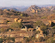
Landschaft im Matopo-Gebirge

Das Matopo-Gebirge (auch Matobo-Gebirge) ist ein Gebirgszug im heutigen Simbabwe südlich der Stadt Bulawayo. Das Matopo-Gebirge beheimatet eine der umfangreichsten Ansammlungen von Steinzeitkunst und Höhlenmalereien im südlichen Afrika. Seit 2003 steht es auf der UNESCO-Liste des Weltkulturerbe.

Die Gegend gilt als das Zentrum des Glaubens der Shona an den Gott Mwari, der dort aus den Felsen spricht. Noch gibt es in den Bergen Orte mit besonderer kultischer Bedeutung, etwa Njelei und Dulu. In dem Gebirgszug liegt das Grab des Gründers des Matabele-Königreichs, Mzilikazi. Der britische Imperialist Cecil John Rhodes, der das Königreich 1893 eroberte, wurde auf seinen eigenen Wunsch ebenfalls dort begraben.

Das Gelände des Matopo-Gebirges ist etwa 100 km mal 30 km groß und liegt 30 km vor Bulawayo. Es besteht aus Granithügeln mit großen verwitterten Felsbrocken, die aufeinander liegen, und aus Schluchten, die mit Büschen bewachsen sind. Es ist ein völlig unüberschaubares Gelände, in dem die dort lebenden Menschen in Kriegszeiten ihr Vieh, ihre Frauen und ihre Kinder für Feinde unauffindbar verstecken konnten.

Ein Teil des Gebirges ist geschützt durch den Matobo-Nationalpark.

Weblinks

Eintrag in der Welterbeliste der UNESCO auf Englisch und auf Französisch

-20.528.57Koordinaten: 20° 30′ 0″ S, 28° 30′ 0″ O


Wikimedia Foundation.

Игры ⚽ Поможем написать курсовую

Schlagen Sie auch in anderen Wörterbüchern nach:

  • Matobo National Park — IUCN Category II (National Park) Sunrise in Matobo National Park, 2006 …   Wikipedia

  • List of national parks in Africa — Namib Naukluft National Park in Namibia. This is a list of national parks in Africa. The nature of the parks varies considerably not only between countries but also within some nations – the degree of protection, accessibility and type of… …   Wikipedia

  • Zimbabwe Parks and Wildlife Estate — The flag of the Zimbabwe Parks and Wildlife Estate Zimbabwe s Game Reserves are managed by the government. They were initially founded as a means of using unproductive land. Little regard was given to modern conservation values, but once these… …   Wikipedia

  • Monts Matobo — 20° 33′ 00″ S 28° 30′ 29″ E / 20.55, 28.508 …   Wikipédia en Français

  • Matobo-Nationalpark — Sonnenuntergang im Matobo Nationalpark Der Matobo National Park oder auch Matopos National Park (ältere Bezeichnung) liegt in Matabeleland in Simbabwe rund 35 km südlich von Bulawayo. Er ist der älteste Nationalpark des Landes, gegründet 1926 als …   Deutsch Wikipedia

  • Matopo Hills — ▪ hills, Zimbabwe Matopo also spelled  Matopos  or  Matobo        mass of granite hills, southeast of Bulawayo, Zimbabwe, formed by river erosion and weathered into fantastic shapes and deep valleys. The hills are associated with folklore and… …   Universalium

  • Bulawayo — /booh leuh way yoh, wah /, n. a city in SW Zimbabwe: mining center. 318,000. * * * City (pop., 1998 est.: 790,000), southwestern Zimbabwe. One of the country s largest cities, it lies 4,400 ft (1,340 m) above sea level. Originally the… …   Universalium

  • Kronadler — Kronenadler Kronenadler (Stephanoaetus coronatus) Systematik Klasse: Vögel (Aves) Ordnung …   Deutsch Wikipedia

  • Stephanoaetus — Kronenadler Kronenadler (Stephanoaetus coronatus) Systematik Klasse: Vögel (Aves) Ordnung …   Deutsch Wikipedia

  • Stephanoaetus coronatus — Kronenadler Kronenadler (Stephanoaetus coronatus) Systematik Klasse: Vögel (Aves) Ordnung …   Deutsch Wikipedia

Share the article and excerpts

Direct link
Do a right-click on the link above
and select “Copy Link”