Mohave Valley

Mohave Valley
Mohave Valley
Mohave County Incorporated and Unincorporated areas Mohave Valley highlighted.svg
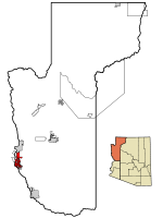
Lage im County und in Arizona
Basisdaten
Staat: Vereinigte Staaten
Bundesstaat: Arizona
County:

Mohave County

Koordinaten: 34° 57′ N, 114° 35′ W34.956944444444-114.58472222222159Koordinaten: 34° 57′ N, 114° 35′ W
Zeitzone: Mountain Standard Time (UTC−7)
Einwohner: 13.694 (Stand: 2000)
Bevölkerungsdichte: 116,8 Einwohner je km²
Fläche: 117,3 km² (ca. 45 mi²)
davon 117,2 km² (ca. 45 mi²) Land
Höhe: 159 m
Postleitzahlen: 86440, 86446
Vorwahl: +1 928
FIPS: 04-47400
GNIS-ID: 1866989

Mohave Valley ist ein Census-designated place (CDP) im Mohave County im US-Bundesstaat Arizona. Es hat 13.694 Einwohner auf einer Fläche von 117,6 km². Die Bevölkerungsdichte liegt somit bei 116,8/km².

Das CDP liegt direkt am Colorado River. Im Süden des Gebiets liegen die Seen Topock Marsh Lake, Beal Lake und Topock Bay. Mohave Valley liegt ganz im Fort Mohave Indianer-Reservation. Am Nordende des CSP liegt die Geisterstadt Fort Mohave.

Durch Mohave Valley verläuft die Arizona State Route 95.

Weblinks


Wikimedia Foundation.

Игры ⚽ Поможем сделать НИР

Schlagen Sie auch in anderen Wörterbüchern nach:

  • Mohave Valley — Lugar designado por el censo de los Estados Unidos Mohave Valley …   Wikipedia Español

  • Mohave Valley — Mohave Valley, AZ U.S. Census Designated Place in Arizona Population (2000): 13694 Housing Units (2000): 6672 Land area (2000): 45.256336 sq. miles (117.213366 sq. km) Water area (2000): 0.156142 sq. miles (0.404407 sq. km) Total area (2000):… …   StarDict's U.S. Gazetteer Places

  • Mohave Valley, AZ — U.S. Census Designated Place in Arizona Population (2000): 13694 Housing Units (2000): 6672 Land area (2000): 45.256336 sq. miles (117.213366 sq. km) Water area (2000): 0.156142 sq. miles (0.404407 sq. km) Total area (2000): 45.412478 sq. miles… …   StarDict's U.S. Gazetteer Places

  • Mohave Valley — For the Arizona city in the Mohave Valley, Lower Colorado River, see Mohave Valley, Arizona. Coordinates: 34°57′25″N 114°35′5″W / 34.95694°N 114.58472°W …   Wikipedia

  • Mohave Valley — Original name in latin Mohave Valley Name in other language State code US Continent/City America/Phoenix longitude 34.93306 latitude 114.58885 altitude 144 Population 2616 Date 2011 05 14 …   Cities with a population over 1000 database

  • Mohave Valley, Arizona — For the valley of the same name location, see Mohave Valley. Mohave Valley Coordinates …   Wikipedia

  • Mohave Valley Daily News — The Mohave Valley Daily News is a newspaper in Bullhead City, Arizona, USA.[1][2] It was started in 1926.[3] It is owned by Brehm Communications, and it has a circulation of 9,300.[1] References ^ …   Wikipedia

  • River Valley High School (Mohave Valley, Arizona) — River Valley High School is a high school located in Mohave Valley, Arizona. It is part of the Colorado River Union High School District.External links* [http://www.coloradoriverschools.org/rivervalley/ River Valley High School website] *… …   Wikipedia

  • Mohave County, Arizona — Mohave County Courthouse in Kingman, Arizona …   Wikipedia

  • Mohave City, Arizona —   Ghost town   Mohave City …   Wikipedia

Share the article and excerpts

Direct link
Do a right-click on the link above
and select “Copy Link”