- Ngaraard
-
Ngaraard 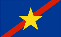
Geographie Staat: Palau Gewässer: Pazifischer Ozean Inseln: Babelthuap Geographische Lage: 8° N, 135° O7.6166666666667134.63333333333Koordinaten: 8° N, 135° O Basisdaten Fläche: 36 km² Einwohner: 581 Bevölkerungsdichte: 16 Einw./km² Hauptstadt: Ulimang Lagekarte 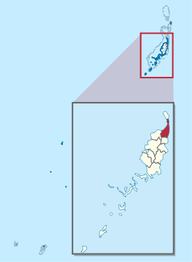
Ngaraard ist ein administrativer Staat (d.h. ein Verwaltungsgebiet) der westpazifischen Inselrepublik Palau. Er liegt im Norden der Hauptinsel Babelthuap.
Das aus den Dörfern (hamlets) Chelab, Chol, Ngebuked, Ngkeklau und dem Hauptort Ulimang bestehende 36 km² große Teilstaat grenzt nördlich an Ngarchelong und südlich an Ngardmau und Ngiwal. In den Siedlungen von Ngaraard leben (laut Volkszählung von 2005) rund 580 Menschen[1].
Einzelnachweise
Schlagen Sie auch in anderen Wörterbüchern nach:
Ngaraard — is the eighth state of the Republic of Palau, and was originally named Kerradel. Ngaraard is located on the northern tip of Babeldaob directly adjacent to Ngarchelong state. There are five hamlets in Ngaraard, including Choll, Elab, Ngebuked,… … Wikipedia
Ngaraard — Estado de Palaos Capital Ulimang Entidad Estado • País … Wikipedia Español
Ngaraard — 7° 37′ 00″ N 134° 38′ 00″ E / 7.61666, 134.63333 … Wikipédia en Français
Ngaraard — Admin ASC 1 Code Orig. name Ngaraard Country and Admin Code PW.08 PW … World countries Adminstrative division ASC I-II
Ulimang — The village of Ulimang is where the Ngaraard State Office (Ngaraard Branch) is located. Note: Another state office branch is located in Meketii, Koror. Ngaraard Elementary school is located here. Ulimang s coast is an orange, sandy beach, and a… … Wikipedia
PW-214 — Administrative Gliederung von Palau. Ngaraard ist ein administrativer Staat (d.h. ein Verwaltungsgebiet) der westpazifischen Inselrepublik Palau. Er liegt im Norden der Hauptinsel Babelthuap. Hauptort ist Ulimang. Das etwa 36 km² große… … Deutsch Wikipedia
PW-218 — Flagge von Ngarchelong Administrative Gliederung von Palau. Ngarchelong ist ein administrativer Staat (d.h. ein Verwaltungsgebiet) der westpazifischen … Deutsch Wikipedia
Elab — is a village in the state of Ngaraard, north of the villages of Ngebuked and Ulimang. It is the home to Ngaraard s only private Christian (Protestant) high school, Bethania Girl s High School in Ngesang, a small portion of Elab village. In… … Wikipedia
Ngkeklau — is a populated area in the southern region of the state of Ngaraard in the Republic of Palau. The town has a small population, on the east coastal plains of Ngaraard. The town includes several ancient relics of stone, such as stone paths,… … Wikipedia
Maderangebuked — Maderangebuked, is Ngaraard State s highest ranking chief title. This chief title is passed down to men, through their mother s family lineage.The Chief Maderangebuked is considered the head of the council of chiefs in Ngaraard. The chief title s … Wikipedia
Ngaraard


18+
© Academic, 2000-2026
- Kontaktieren Sie uns: Unterstützung, Werbung
Wörterbücher Export, schritte mit PHP, Joomla, Drupal, WordPress, MODx.