Peleliu (Palau)

Peleliu (Palau)
Peleliu
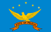
Flagge von Peleliu
Geographie
Staat: Palau
Gewässer: Pazifischer Ozean
Inseln: Hauptinsel sowie 10 kl. Inseln
Geographische Lage: 7° N, 134° O7.0416666666667134.26388888889Koordinaten: 7° N, 134° O
Basisdaten
Fläche: 13 km²
Einwohner: 702
Bevölkerungsdichte: 54 Einw./km²
Hauptstadt: Kloulklubed
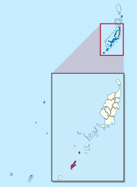
Lagekarte
Peleliu in Palau.svg

Peleliu ist ein administrativer Staat (d. h. ein Verwaltungsgebiet) der pazifischen Inselrepublik Palau. Es liegt südwestlich der Provinz Koror und nordöstlich der Provinz Angaur.

Zum Gebiet des Staates Peliliu zählen neben der gleichnamigen Insel Peleliu noch etwa 10 kleinere Inseln; die gesamte Landfläche beträgt 13 km². Die Hauptstadt Kloulklubed liegt im Nordwesten der Hauptinsel. Der Staat besteht laut Verfassung[1] aus den fünf Dörfern (hamlets) Teliu an der Südwestküste grenzt im Norden an Ngerkeukl, Ngesias im Zentrum, Ngerdelolk an der Ostküste und Ngerchol im nördlichen Teil der Insel. Im gesamten Verwaltungsgebiet lebten 2005 702[2] Menschen, davon 571 auf der Insel Peleliu (Zensus: 2005).

Zum Staat Peliliu gehören u.a. folgende Inseln:

Inselname Fläche (km²), ca. Einwohner Geokoordinate
Peleliu 12,8 571 7° 1′ N, 134° 15′ O7.0124027777778134.25034444444
Ngercheu 0,93 50 7° 6′ N, 134° 17′ O7.0926416666667134.27808888889
Ngesebus 0,95 0 7° 3′ N, 134° 16′ O7.0566444444444134.25998333333
Ngurungor 0,54 0 7° 1′ N, 134° 16′ O7.0212194444444134.272425
Kongauru 0,34 0 7° 4′ N, 134° 16′ O7.0633111111111134.27392777778
Murphy Island 0,02 0 7° 4′ N, 134° 17′ O7.0652694444444134.28243055556
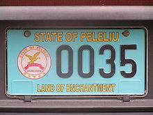
Kfz-Kennzeichen von Peleliu

Weblinks

Einzelnachweise

  1. Constitution of Peleliu State (engl.)
  2. www.statoids.com


Wikimedia Foundation.

Игры ⚽ Поможем написать реферат

Schlagen Sie auch in anderen Wörterbüchern nach:

  • Peleliu (Insel) — Peleliu Karte von Peleliu Gewässer Pazifischer Ozean Inselgruppe …   Deutsch Wikipedia

  • Peleliu — ist die Bezeichnung mehrerer Orte: Peleliu (Insel), eine Insel von Palau Peleliu (Palau), ein Staat (Verwaltungsgebiet) von Palau Diese Seite ist eine Begriffsklärung zur Unterscheidung mehrerer mit demselben Wort bezeichn …   Deutsch Wikipedia

  • Palau — [pä lou′] country consisting of a group of islands in the W Pacific Ocean: formerly part of the Trust Territory of the Pacific Islands, the island group became an independent republic in 1994: 630 sq mi (1,632 sq km); pop. 15,000; cap. Koror * *… …   Universalium

  • Peleliu — Saltar a navegación, búsqueda Peleliu Estado de Palau Capital Kloulklubed Entidad Estado …   Wikipedia Español

  • Peleliu — (or Beliliou) is an island in the island nation of Palau. Peleliu forms, along with two small islands to its northeast, one of the sixteen states of Palau. It is located northeast of Angaur and southwest of Koror. on the northern coast. Including …   Wikipedia

  • Palau-Eule — Systematik Klasse: Vögel (Aves) Ordnung: Eulen (Strigiformes) Familie: Eigentliche Eulen (Strigidae) Gattung …   Deutsch Wikipedia

  • Peleliu — o Beliliou es una isla de Palau. La isla junto con dos pequeñas islas al noroeste, uno de los dieciséis estados de Palau. Se localiza al noroeste de Angaur y el suroeste de Koror. Tiene un área de 13 km². En el 2004, tenía una población de 700… …   Enciclopedia Universal

  • Palau — This article is about the country. For other uses, see Palau (disambiguation). Republic of Palau Beluu ęr a Belau …   Wikipedia

  • Palau — <p></p> <p></p> Introduction ::Palau <p></p> Background: <p></p> After three decades as part of the UN Trust Territory of the Pacific under US administration, this westernmost cluster of the… …   The World Factbook

  • Palau-Inseln — Palauinseln Lage der Palauinseln Gewässer Pazifischer Ozean Anzahl der Inseln über 300 Hauptinsel …   Deutsch Wikipedia

Share the article and excerpts

Direct link
Do a right-click on the link above
and select “Copy Link”