- Ngardmau
-
Ngardmau Geographie Staat: Palau Gewässer: Pazifischer Ozean Inseln: Babelthuap Geographische Lage: 8° N, 135° O7.6134.55Koordinaten: 8° N, 135° O Basisdaten Fläche: 47 km² Einwohner: 166 Bevölkerungsdichte: 4 Einw./km² Hauptstadt: Urdmang Lagekarte 
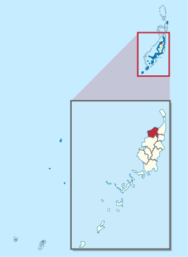
Ngardmau ist ein administrativer Staat (d. h. ein Verwaltungsgebiet) der pazifischen Inselrepublik Palau. Er liegt im Norden der Hauptinsel Babelthuap. Auf dem 47 km² großen Gebiet von Ngardmau leben nach der Volkszählung 2005 166 Personen[1]. Diese konzentrieren sich in den drei Ortschaften Ngetbong, Ngerutoi und dem Hauptort Urdmang.
Die höchste Erhebung des Bezirks ist der 213 m hohe Mt. Ngerchelchuus. Am Fuß des Berges findet sich eines der ältesten Waldgebiete Palaus, in dem viele Vogelarten heimisch sind.
Einzelnachweise
Weblinks
Schlagen Sie auch in anderen Wörterbüchern nach:
Ngardmau — is one of Palau s sixteen states and is located on the west side of Babeldaob between the states of Ngaraard and Ngeremlengui. Its total area is 20.5 square miles (53 km2). According to the last census, 221 persons live in Ngardmau. Their 46 … Wikipedia
Ngardmau — es uno de los dieciséis estados de las islas Palaos y está localizado sobre el lado de oeste de Babeldaob entre los estados de Ngaraard y Ngeremlengui. Su área total es de 47 kilómetros cuadrados. Según el último censo, 221 personas viven en… … Wikipedia Español
Ngardmau — 7°36′N 134°33′E / 7.6, 134.55 … Wikipédia en Français
Ngardmau — Original name in latin Ngardmau Name in other language State code PW Continent/City Pacific/Palau longitude 7.60986 latitude 134.5744 altitude 24 Population 221 Date 2013 08 05 … Cities with a population over 1000 database
Ngardmau — Admin ASC 1 Code Orig. name Ngardmau Country and Admin Code PW.10 PW … World countries Adminstrative division ASC I-II
Sakaziro Demk — The 16 states of Palau Sakaziro Demk of Ngardmau state is a high chief beouch and one of the many chiefs of Palau.[1] High chief beouch is the position of highest political and social leadership in a village, and is held by a son of the oldest… … Wikipedia
Ngaraard — is the eighth state of the Republic of Palau, and was originally named Kerradel. Ngaraard is located on the northern tip of Babeldaob directly adjacent to Ngarchelong state. There are five hamlets in Ngaraard, including Choll, Elab, Ngebuked,… … Wikipedia
Palau — This article is about the country. For other uses, see Palau (disambiguation). Republic of Palau Beluu ęr a Belau … Wikipedia
Ngaraard — Geographie Staat: Palau Gewässer: Pazifischer Ozean … Deutsch Wikipedia
PW-214 — Administrative Gliederung von Palau. Ngaraard ist ein administrativer Staat (d.h. ein Verwaltungsgebiet) der westpazifischen Inselrepublik Palau. Er liegt im Norden der Hauptinsel Babelthuap. Hauptort ist Ulimang. Das etwa 36 km² große… … Deutsch Wikipedia