- Ninohe
-
Ninohe-shi
二戸市

Geographische Lage in Japan Region: Tōhoku Präfektur: Iwate Koordinaten: 40° 16′ N, 141° 18′ O40.271111111111141.305Koordinaten: 40° 16′ 16″ N, 141° 18′ 18″ O Basisdaten Fläche: 420,31 km² Einwohner: 29.342
(1. Oktober 2011)Bevölkerungsdichte: 70 Einwohner je km² Gemeindeschlüssel: 03213-1 Symbole Flagge/Wappen: 
Rathaus Adresse: Ninohe City Hall
47 Aza Kawamata, Fukuoka
Ninohe-shi
Iwate 028-6192Webadresse: http://www.city.ninohe.iwate.jp Lage Ninohes in der Präfektur Iwate 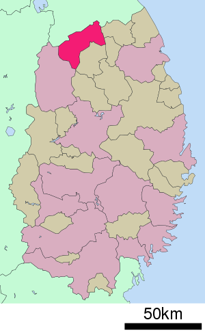
Ninohe (jap. 二戸市, -shi) ist eine Stadt in der Präfektur Iwate auf Honshu, der Hauptinsel von Japan.
Inhaltsverzeichnis
Geographie
Ninohe liegt südwestlich von Hachinohe und nördlich von Morioka.
Geschichte
Die Stadt Ninohe wurde am 1. April 1972 aus den ehemaligen Gemeinden Fukuoka und Kindaichi gegründet.
Verkehr
- Straße:
- Hachinohe-Autobahn
- Nationalstraße 4
- Nationalstraße 395
- Zug:
- JR Tohoku-Shinkansen, Bahnhof Ninohe
- IGR-Iwate-Ginga-Eisenbahn
Angrenzende Städte und Gemeinden
Weblinks
 Commons: Ninohe – Sammlung von Bildern, Videos und Audiodateien
 Gemeinden und Landkreise in der Präfektur Iwate
Kreisfreie Städte (shi): Hachimantai | Hanamaki | Ichinoseki | Kamaishi | Kitakami | Kuji | Miyako | Morioka (Verwaltungssitz) | Ninohe | Ōfunato | Ōshū | Rikuzentakata | Tōno
Higashiiwai-gun: Fujisawa | Isawa-gun: Kanegasaki | Iwate-gun: Iwate | Kuzumaki | Shizukuishi | Takizawa | Kamihei-gun: Ōtsuchi | Kesen-gun: Sumita | Kunohe-gun: Karumai | Kunohe | Noda | Hirono | Ninohe-gun: Ichinohe | Nishiiwai-gun: Hiraizumi | Shimohei-gun: Fudai | Iwaizumi | Tanohata | Yamada | Shiwa-gun: Shiwa | Yahaba | Waga-gun: Nishiwaga
Wikimedia Foundation.
Schlagen Sie auch in anderen Wörterbüchern nach:
Ninohe, Iwate — Ninohe 二戸市 City … Wikipedia
Ninohe Station — 二戸駅 Location Prefecture Iwate (See other stations in Iwate) … Wikipedia
Ninohe District, Iwate — Ninohe (二戸郡, Ninohe gun?) is a district located in Iwate Prefecture, Japan. As of May 2008, the district has an estimated Population of 14,880 and a population density of 49.6 persons/km². The total area is 300.11 km². The district contains… … Wikipedia
Ninohe Shi — Admin ASC 2 Code Orig. name Ninohe Shi Country and Admin Code JP.16.2128940 JP … World countries Adminstrative division ASC I-II
Ninohe-gun — Admin ASC 2 Code Orig. name Ninohe gun Country and Admin Code JP.16.2128941 JP … World countries Adminstrative division ASC I-II
JR Bus Tohoku Company — Infobox Company company name = JR Bus Tohoku Company ジェイアールバス東北株式会社 company type = KK foundation = March 1, 1988 location = Sendai, Miyagi, Japan homepage = [http://www.jrbustohoku.co.jp/ www.jrbustohoku.co.jp] nihongo|JR Bus Tohoku… … Wikipedia
Morioka Station — 盛岡駅 Morioka Station front entrance Location Prefecture Iwat … Wikipedia
Jōbōji, Iwate — was a town located in Ninohe District, Iwate, Japan. It merged into the city of Ninohe. As of 2003, the town had an estimated population of 5,130 and a density of 28.55 persons per km². The total area was 179.70 km².On January 1, 2006, the… … Wikipedia
Kintaichi-Onsen Station — is a railway station on the Iwate Ginga Railway Iwate Ginga Railway Line. It is located in Ninohe, Iwate, Japan.tation structure* 2 way, 3 track, above ground station.; Platforms * Kintaichi Onsen Station is a simple consignment station,… … Wikipedia
Iwate-gun (Iwate) — Iwate (jap. 岩手郡, gun) ist ein Landkreis in der japanischen Präfektur Iwate. Am 1. Januar 2008 umfasste der Landkreis eine Fläche von 1.586,87 km²; die geschätzte Einwohnerzahl betrug 95.522, die Bevölkerungsdichte mithin circa… … Deutsch Wikipedia
- Straße:
Ninohe


18+
© Academic, 2000-2026
- Kontaktieren Sie uns: Unterstützung, Werbung
Wörterbücher Export, schritte mit PHP, Joomla, Drupal, WordPress, MODx.