- Sandwich Harbour
-
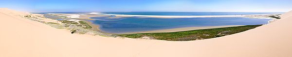 Die Lagune von Sandwich Harbour
Sandwich Harbour (selten Sandwichhafen; portugiesisch: Porto d'Ilheo) liegt im Südatlantik, circa 42 Kilometer südlich der Stadt Walvis Bay in Namibia.
Sandwich Harbour ist sowohl die Bezeichnung eines ehemaligen Hafens an der namibischen Südatlantikküste, als auch eine Bezeichnung für diese Bucht selbst. Diese wird sehr selten auch Sandwichbucht (Afrikaans: Sandwichbaai; Englisch: Sandwich Bay) genannt. Heute versteht man darunter meist die Lagune, die aufgrund zunehmender Versandungen der Meeresbucht entsteht. Es handelt sich folglich nicht mehr um eine Bucht im klassischen Sinne. Die Lagune ist etwa 10 km lang.
Inhaltsverzeichnis
Natur und Umwelt
Sandwich Harbour ist Feuchtgebiet, das durch die Ramsar-Konvention international als besonders wichtig anerkannt wurde. Sandwich Harbour ist einer der vier Sektionen des Namib-Naukluft-Park. Er kann nur tagsüber von Walvis Bay aus mit Booten oder Allradfahrzeugen erreicht werden.
Das Gebiet ist see- und landseits von Schilfgräsern und Sanddünen der Namib umgeben, und die sich durch Verschiebungen der Sandmassen in ihr liegende Lagune ist – ebenso wie das größere Walvis-Bay-Feuchtgebiet – eine riesige Vogelkolonie (bis zu 450.000 Tiere), welche unzähligen Seevögel einen optimalen Lebensraum bietet; darunter (Zählung 2008[1]):
- 45.000 Kleine Flamingos
- 10.000 Große Flamingos
- 60.000–170.000 Seeschwalben
sowie unter anderem Kormoranen, Pelikanen und sonstigen Wassertieren.
Das Gebiet ist eine national und international anerkannte Important Bird Area.
Geschichte
Der Sandwichhafen, auch Sandfischhafen (von afrikaans: Sandvis) genannt, ging auf einen von portugiesische Seefahrern 1486 gegründeten Hafen zurück, war jedoch im Laufe seiner Geschichte kaum mehr als ein verlassener Punkt zwischen der Wüste Namib und dem Atlantischen Ozean. Ein etwa 20 km nördlich gesetztes Padrão (steinernes Kreuz) zeugt von dieser Vergangenheit. Die schwer zugängliche Küste wurde 1796 durch England annektiert, der auf die Portugiesen zurückgehende Sandwichhafen wurde jedoch 1884 Teil von Deutsch-Südwestafrika und kurzzeitig Anlaufstelle für die Kolonie. 1889 erlangte der Hafen politische und wirtschaftliche Relevanz als Versorgungshafen des damaligen Deutsch-Südwestafrika und in direkter Nachbarschaft des damals englischen Walfischbucht. Zeitweilig bestanden eine Fischereianlage und eine Schlachterei. Der Hafen selbst ist jedoch ab 1893 in seiner Funktion durch den Hafen von Swakopmund abgelöst worden.
Literatur
- Mary Seely, John Pallett: Namib - Secrets of a desert uncovered. Venture Publications, Windhoek 2008, ISBN 978-3-941602-06-9.
- Heinrich Schnee (Hrsg.): Deutsches Kolonial-Lexikon, Band 3, Leipzig 1920, S. 250.
Einzelnachweise
- ↑ Mary Seely, John Pallett: Namib - Secrets of a desert uncovered. Venture Publications, Windhoek 2008, ISBN 978-3-941602-06-9, S. 33-49.
-23.36666666666714.483333333333Koordinaten: 23° 22′ 0″ S, 14° 29′ 0″ OKategorien:- Geschichte (Namibia)
- Bucht in Namibia
- Bucht (Atlantischer Ozean)
- Walvis Bay
- Erongo
- Lagune
- Ramsar-Gebiet
- Geographie (Afrika)

Wikimedia Foundation.