- Shire of Cardinia
-
Shire of Cardinia 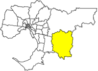
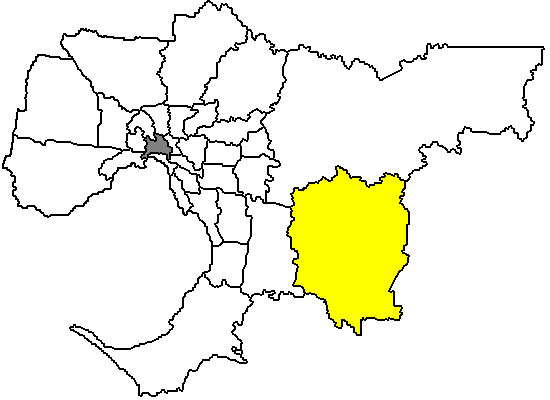
Lage von Cardinia Shire in Melbourne Basisdaten Bundesstaat: Victoria Hauptort: Pakenham Fläche: 1.280 km² Einwohner: 60.276 (Juni 2006) Wards: 4 Stadtteile: 21 Cardinia Shire ist ein lokales Verwaltungsgebiet (LGA) im australischen Bundesstaat Victoria. Cardinia gehört zur Outer Metropolitan Area von Melbourne, dem äußeren Großstadtgebiet der Hauptstadt Victorias. Das Gebiet ist 1.280 km² groß und hat etwa 60.000 Einwohner.
Cardinia liegt 47 bis 83 km vom Stadtzentrum entfernt am Südostende von Melbourne an der Western Port Bay und enthält 21 Stadtteile und Ortschaften: Beaconsfield, Beacondsfield Upper, Beenak, Bunyip, Cardinia, Clematis, Cockatoo, Cory Lynn, Dewhurst, Emerald, Garfield, Gembrook, Koo Wee Rup, Lang Lang, Maryknoll, Nar Nar Goon, Officer, Pakenham, Rythdale, Tonimbuk und Tynong. Der Sitz des City Councils befindet sich in Pakenham.
Cardinia ist Übergangsgebiet zwischen den zur Greater Metropolitan Area gehörenden Stadtteilen und den ländlichen Vororten der Großstadt. Es gehört zu den landwirtschaftlichen geprägten Regionen, neben Obst- und Gemüseanbau wird hier vor allem Viehzucht betrieben. Das Gebiet um Lang Lang und Koo Wee Rup ist ein Zentrum des Spargelanbaus.
Durch den Norden des Shires von Gembrook über Cockatoo, Lakeside und Emerald führt die historische Eisenbahnstrecke der Dampflokomotive Puffing Billy, die letzte als Touristenattraktion erhaltene von ehemals vier Bahnstrecken, die die ländlichen Gebiete mit dem Innenstadtnetz Melbournes verbanden. Die 24 km lange Strecke beginnt in Belgrave in den Yarra Ranges.
In Emerald gibt es auch die größte Modelleisenbahnanlage Australiens. Die H0--Bahn verfügt über 2.000 m Schienenstrecke.
Verwaltung
Der Cardinia Shire Council hat sieben Mitglieder, die von den Bewohnern der vier Wards gewählt werden (drei Councillor aus dem Central, zwei aus Ranges und je einer aus Bunyip und Port Ward). Diese vier Bezirke sind unabhängig von den Stadtteilen festgelegt. Aus dem Kreis der Councillor rekrutiert sich auch der Mayor (Bürgermeister) des Councils.
Weblinks
Ländliche Gebiete: Alpine | Ararat | Ballarat | Bass Coast | Baw Baw | Benalla | Buloke | Campaspe | Central Goldfields | Colac Otway | Corangamite | East Gippsland | Gannawarra | Glenelg | Golden Plains | Greater Bendigo | Greater Geelong | Greater Shepparton | Hepburn | Hindmarsh | Horsham | Indigo | Latrobe | Loddon | Macedon Ranges | Mansfield | Mildura | Mitchell | Moira | Moorabool | Mount Alexander | Moyne | Murrindindi | Northern Grampians | Pyrenees | Queenscliffe | South Gippsland | Southern Grampians | Strathbogie | Surf Coast | Swan Hill | Towong | Wangaratta | Warrnambool | Wellington | West Wimmera | Wodonga | Yarriambiack
Greater Melbourne: Banyule | Bayside | Boroondara | Brimbank | Cardinia | Casey | Darebin | Frankston | Glen Eira | Greater Dandenong | Hobsons Bay | Hume | Kingston | Knox | Manningham | Maroondah | Maribyrnong | Melbourne | Melton | Monash | Moonee Valley | Moreland | Mornington Peninsula | Nillumbik | Port Phillip | Stonnington | Whitehorse | Whittlesea | Wyndham | Yarra | Yarra Ranges
Wikimedia Foundation.