- Shire of East Gippsland
-
Shire of East Gippsland 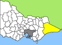
Lage des East Gippsland Shire in Victoria Basisdaten Bundesstaat: Victoria Hauptort: Bairnsdale Fläche: 20.170 km² Einwohner: 42.075 (Juni 2006) Wards: 2 East Gippsland Shire ist ein lokales Verwaltungsgebiet (LGA) im australischen Bundesstaat Victoria. Das Gebiet ist 20.170 km² groß und hat etwa 42.000 Einwohner.
East Gippsland bildet die Ostspitze von Victoria und liegt etwa 300 bis 500 km entfernt von der Hauptstadt Melbourne. Das Gebiet schließt folgende Ortschaften ein: Allenvale, Bairnsdale, Benambra, Bendoc, Bruthen, Buchan, Ensay, Lakes Entrance, Mallacoota, Metung, Omeo, Orbost, Paynesville und Swifts Creek. Der Sitz des City Councils befindet sich in Bairnsdale im Südwesten der LGA.
Das Gippsland gehörte zu den ersten Siedlungsgebieten der Europäer in Victoria, die hier von Sydney in Richtung Süden zogen. Bereits Mitte der 30er Jahre des 19. Jahrhunderts ließen sich Siedler in der Gegend zwischen Benambra und Omeo nieder. Ab 1850 führten dann Goldfunde in der Region um Omeo zu neuen und größeren Siedlungen. Vor der Ankunft der Eisenbahn profitierten auch viele Städte an der Route nach Melbourne. Omeo ist als historische Goldgräberstadt heute eine Touristenattraktion.
East Gippsland ist die zweitgrößte LGA Victorias und drei Viertel des Gebiets sind Nationalpark. Entsprechend herrscht hier neben der Land- und Forstwirtschaft vor allem der Tourismus vor. Attraktionen sind der Ninety Mile Beach, der längste zusammenhängende Sandstrand Australiens (ca. 150 km lang), sowie vor allem die Gippsland-Seen parallel zur Küste westlich von Lakes Entrance. Dort wurde Ende des 19. Jahrhunderts eine künstliche, dauerhafte Zufahrt von der Bass-Straße zum Seengebiet für große Schiffe geschaffen.
Nördlich davon ist die Landschaft des Shires hügelig bis bergig. Von Bairnsdale nach Wangaratta führt die 300 km lange Great Alpine Road, die höchstgelegene befestigte Straße in Victoria. Sie führt durch den Alpine-Nationalpark, der am Südende der Great Dividing Range liegt. Am Mount Hotham erreicht die Straße auf 1750 m Höhe ihren höchsten Punkt. Am und um den Berg befinden sich auch einige Winterskigebiete.
Verwaltung
Der East Gippsland Shire Council hat acht Mitglieder, die von den Bewohnern der zwei Wards gewählt werden. Aus jedem dieser zwei Bezirke, Waratah und Banksia, kommen vier Councillor. Aus dem Kreis der Councillor rekrutiert sich auch der Mayor (Bürgermeister) des Councils.
Weblinks
- Website des East Gippsland Shire (englisch)
- Tourismus-Website des East Gippsland Shire (englisch)
Ländliche Gebiete: Alpine | Ararat | Ballarat | Bass Coast | Baw Baw | Benalla | Buloke | Campaspe | Central Goldfields | Colac Otway | Corangamite | East Gippsland | Gannawarra | Glenelg | Golden Plains | Greater Bendigo | Greater Geelong | Greater Shepparton | Hepburn | Hindmarsh | Horsham | Indigo | Latrobe | Loddon | Macedon Ranges | Mansfield | Mildura | Mitchell | Moira | Moorabool | Mount Alexander | Moyne | Murrindindi | Northern Grampians | Pyrenees | Queenscliffe | South Gippsland | Southern Grampians | Strathbogie | Surf Coast | Swan Hill | Towong | Wangaratta | Warrnambool | Wellington | West Wimmera | Wodonga | Yarriambiack
Greater Melbourne: Banyule | Bayside | Boroondara | Brimbank | Cardinia | Casey | Darebin | Frankston | Glen Eira | Greater Dandenong | Hobsons Bay | Hume | Kingston | Knox | Manningham | Maroondah | Maribyrnong | Melbourne | Melton | Monash | Moonee Valley | Moreland | Mornington Peninsula | Nillumbik | Port Phillip | Stonnington | Whitehorse | Whittlesea | Wyndham | Yarra | Yarra Ranges

Wikimedia Foundation.