- Shire of Mansfield
-
Mansfield Shire 
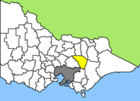
Lage des Mansfield Shire in Victoria Basisdaten Bundesstaat: Victoria Hauptort: Mansfield Fläche: 2.341 km² Einwohner: 7.460 (Juni 2006) Wards: 4 Mansfield Shire ist ein lokales Verwaltungsgebiet (LGA) im australischen Bundesstaat Victoria. Das Gebiet ist 2.341 km² groß und hat etwa 7.500 Einwohner.
Mansfield liegt im Zentrum des Ostens von Victoria etwa 180 km nordöstlich des Stadtzentrums von Melbourne und grenzt im Südosten an den Großraum Melbourne an. Das Shire schließt folgende Ortschaften ein: Kevington, Woods Point, Bonnie Doon, Merton, Tolmie, Merrijig, Sawmill Settlement, Mansfield, Goughs Bay, Macs Cove und Jamieson. Der Sitz des City Councils befindet sich in Mansfield im Zentrum der LGA.
Das Gebiet zwischen der Metropole Melbourne und den hohen Gebirgen der Great Dividing Range ist ein großes Tourismusziel: Jährlich besuchen etwa 1,2 Millionen Touristen das dünn besiedelte "High Country" am Südwestende des Alpine National Parks, des größten Nationalparks Victorias. Besondere Attraktionen sind das Skigebiet am 1805 m hohen Mount Buller sowie der Lake Eildon, das zweitgrößte Wasserreservoir Victorias nach der Dartmouth-Talsperre, mit einer Fläche von 13.840 ha und 483 km Küstenlinie.
Verwaltung
Der Mansfield Shire Council hat fünf Mitglieder, die von den Bewohnern der vier Wards gewählt werden. Von diesen vier Wahlbezirken stellen Bonnie Doon, Jamieson und Tolmie je einen, Mansfield Ward zwei Councillor. Aus dem Kreis der Councillor rekrutiert sich auch der Mayor (Bürgermeister) des Councils.
Weblinks
- Offizielle Seite des Councils (engl.)
Ländliche Gebiete: Alpine | Ararat | Ballarat | Bass Coast | Baw Baw | Benalla | Buloke | Campaspe | Central Goldfields | Colac Otway | Corangamite | East Gippsland | Gannawarra | Glenelg | Golden Plains | Greater Bendigo | Greater Geelong | Greater Shepparton | Hepburn | Hindmarsh | Horsham | Indigo | Latrobe | Loddon | Macedon Ranges | Mansfield | Mildura | Mitchell | Moira | Moorabool | Mount Alexander | Moyne | Murrindindi | Northern Grampians | Pyrenees | Queenscliffe | South Gippsland | Southern Grampians | Strathbogie | Surf Coast | Swan Hill | Towong | Wangaratta | Warrnambool | Wellington | West Wimmera | Wodonga | Yarriambiack
Greater Melbourne: Banyule | Bayside | Boroondara | Brimbank | Cardinia | Casey | Darebin | Frankston | Glen Eira | Greater Dandenong | Hobsons Bay | Hume | Kingston | Knox | Manningham | Maroondah | Maribyrnong | Melbourne | Melton | Monash | Moonee Valley | Moreland | Mornington Peninsula | Nillumbik | Port Phillip | Stonnington | Whitehorse | Whittlesea | Wyndham | Yarra | Yarra Ranges
Wikimedia Foundation.
