- Uto (Kumamoto)
-
Uto-shi
宇土市

Geographische Lage in Japan Region: Kyūshū Präfektur: Kumamoto Koordinaten: 32° 41′ N, 130° 40′ O32.687155555556130.6587Koordinaten: 32° 41′ 14″ N, 130° 39′ 31″ O Basisdaten Fläche: 74,19 km² Einwohner: 37.608
(1. Juli 2011)Bevölkerungsdichte: 507 Einwohner je km² Gemeindeschlüssel: 43211-3 Symbole Baum: Osmanthus fragrans var. aurantiacus Blume: Gartenhortensie Vogel: Zosterops japonicus Rathaus Adresse: Uto City Hall
51 Urata-machi
Uto-shi
Kumamoto 869-0492Webadresse: http://www.city.uto.kumamoto.jp Lage Utos in der Präfektur Kumamoto 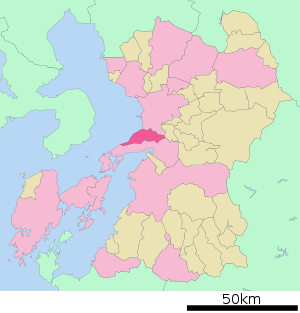
Uto (jap. 宇土市, -shi) ist eine japanische Stadt in der Präfektur Kumamoto auf der Insel Kyūshū.
Inhaltsverzeichnis
Geographie
Uto liegt südlich von Kumamoto und nördlich von Uki und Yatsushiro. Der Westteil der Gemeinde erstreckt sich über den Norden der Uto-Halbinsel (宇土半島, Uto-hantō).
Geschichte
Am 1. Oktober 1958 wurde ein Dorf (網田村) aus dem Landkreis Hōtaku eingemeindet und Uto erhielt das Stadtrecht.
Verkehr
- Straße:
- Nationalstraße 3: nach Kitakyūshū und Kagoshima
- Nationalstraßen 57, 501
- Zug:
- JR Kagoshima-Hauptlinie: nach Kitakyūshū und Kagoshima
- JR Misumi-Linie
Angrenzende Städte und Gemeinden
Weblinks
 Commons: Uto – Sammlung von Bildern, Videos und Audiodateien
 Gemeinden und Landkreise in der Präfektur Kumamoto
Kreisfreie Städte (shi): Amakusa | Arao | Aso | Hitoyoshi | Kami-Amakusa | Kikuchi | Kōshi | Kumamoto (Verwaltungssitz) | Minamata | Tamana | Uki | Uto | Yamaga | Yatsushiro
Amakusa-gun: Reihoku | Ashikita-gun: Ashikita | Tsunagi | Aso-gun: Minamiaso | Minamioguni | Nishihara | Oguni | Takamori | Ubuyama | Kamimashiki-gun: Kashima | Kosa | Mashiki | Mifune | Yamato | Kikuchi-gun: Kikuyō | Ōzu | Kuma-gun: Asagiri | Itsuki | Kuma | Mizukami | Nishiki | Sagara | Taragi | Yamae | Yunomae | Shimomashiki-gun: Misato | Tamana-gun: Gyokutō | Nagasu | Nagomi | Nankan | Yatsushiro-gun: Hikawa
Wikimedia Foundation.
Schlagen Sie auch in anderen Wörterbüchern nach:
Uto, Kumamoto — There is also an article about Uto Districtnihongo|Uto|宇土市|Uto shi is a city located in Kumamoto, Japan.As of 2003, the city has an estimated population of 38,158 and the density of 514.47 persons per km². The total area is 74.17 km².The city was … Wikipedia
Uto — may refer to:* Uto, Kumamoto, a city in Kumamoto Prefecture, Japan * Uto District, Kumamoto, a district in Kumamoto Prefecture, Japan * Untrioctium, (symbol: Uto), an unsynthesized chemical element with atomic number 138 * Uto, another name of… … Wikipedia
Uto — bezeichnet: die Fruchtbarkeitsgöttin der ägyptischen Mythologie; anderer Name Wadjet Uto (Kumamoto), eine japanische Stadt Uto (Han), ein Lehen mit Sitz der jap. Stadt eine in Eigennamen vorkommende Namensvariante des Uetlibergs der römische… … Deutsch Wikipedia
Uto Station — nihongo|Uto Station|宇土駅|Uto eki is a railway station of Kyushu Railway Company located in Uto, Kumamoto Prefecture, Japan. At this station the Misumi Line branches off the Kagoshima Main Line.The station opened on January 28, 1895. References * … Wikipedia
Kumamoto — shi 熊本市 Geographische Lage in Japan … Deutsch Wikipedia
Uto District, Kumamoto — Uto (宇土郡; gun) was a district located in Kumamoto Prefecture, Japan.As of 2003, the district had an estimated population of 19,496 and the density of 252.77 persons per km². The total area was 77.13 km².Former towns and villages* Misumi *… … Wikipedia
Kumamoto Prefecture — Infobox Prefecture Japan Name = Kumamoto JapaneseName = 熊本県 Rōmaji = Kumamoto ken Symbol = PrefSymbol Kumamoto.png Capital = Kumamoto Region = Kyūshū Island = Kyūshū TotalArea = 7,404.14 AreaRank = 16th PCWater = 0.2 PopDate = October 1, 2005… … Wikipedia
Uto Domain — The nihongo|Uto Domain|宇土藩|Uto han was a Japanese domain of the Edo period, located in Higo Province. It was ruled by a branch of the Hosokawa clan of Kumamoto.List of lords*Hosokawa clan, 1646 1870 (Tozama; 30,000 koku)#Yukitaka #Aritaka… … Wikipedia
Prefectura de Kumamoto — Kumamoto 熊本県 Kumamoto ken Prefectura de Japón … Wikipedia Español
Präfektur Kumamoto — 熊本県 Präfektur Kumamoto Basisdaten Verwaltungssitz: Kumamoto Region … Deutsch Wikipedia
- Straße:
Uto (Kumamoto)


18+
© Academic, 2000-2026
- Kontaktieren Sie uns: Unterstützung, Werbung
Wörterbücher Export, schritte mit PHP, Joomla, Drupal, WordPress, MODx.