- Hitoyoshi
-
Hitoyoshi-shi
人吉市

Geographische Lage in Japan Region: Kyūshū Präfektur: Kumamoto Koordinaten: 32° 13′ N, 130° 46′ O32.210038888889130.76255555556Koordinaten: 32° 12′ 36″ N, 130° 45′ 45″ O Basisdaten Fläche: 210,55 km² Einwohner: 35.327
(1. Juli 2011)Bevölkerungsdichte: 168 Einwohner je km² Gemeindeschlüssel: 43203-2 Symbole Flagge/Wappen: 
Baum: Eiche Blume: Ume Vogel: Japanbuschsänger Rathaus Adresse: Hitoyoshi City Hall
16 Fumoto-machi
Hitoyoshi-shi
Kumamoto 868-8601Webadresse: http://www.city.hitoyoshi.kumamoto.jp Lage Hitoyoshis in der Präfektur Kumamoto 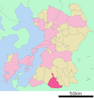
Hitoyoshi (jap. 人吉市, -shi) ist eine japanische Stadt in der Präfektur Kumamoto auf der Insel Kyūshū.
Inhaltsverzeichnis
Geschichte
Die Stadt Hitoyoshi entstand am 11. Februar 1942 aus dem Zusammenschluss der Gemeinde Hitoyoshi (人吉町, -machi) mit 3 Dörfern (西瀬村, 中原村, 藍田村) im Landkreis Kuma.
Sehenswürdigekeiten
- Überreste der Burg Hitoyoshi (人吉城, Hitoyoshi-jō)
Verkehr
- Straße:
- Kyūshū-Autobahn
- Nationalstraßen 219, 221, 267, 445
- Zug:
- JR Hisatsu-Linie: nach Yatsushiro und Kirishima
- Kumagawa Rail Yunomae-Linie
Angrenzende Städte und Gemeinden
Weblinks
 Commons: Hitoyoshi – Sammlung von Bildern, Videos und Audiodateien
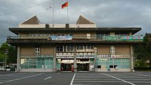 Rathaus von Hitoyoshi
 Gemeinden und Landkreise in der Präfektur Kumamoto
Kreisfreie Städte (shi): Amakusa | Arao | Aso | Hitoyoshi | Kami-Amakusa | Kikuchi | Kōshi | Kumamoto (Verwaltungssitz) | Minamata | Tamana | Uki | Uto | Yamaga | Yatsushiro
Amakusa-gun: Reihoku | Ashikita-gun: Ashikita | Tsunagi | Aso-gun: Minamiaso | Minamioguni | Nishihara | Oguni | Takamori | Ubuyama | Kamimashiki-gun: Kashima | Kosa | Mashiki | Mifune | Yamato | Kikuchi-gun: Kikuyō | Ōzu | Kuma-gun: Asagiri | Itsuki | Kuma | Mizukami | Nishiki | Sagara | Taragi | Yamae | Yunomae | Shimomashiki-gun: Misato | Tamana-gun: Gyokutō | Nagasu | Nagomi | Nankan | Yatsushiro-gun: Hikawa
Wikimedia Foundation.
Schlagen Sie auch in anderen Wörterbüchern nach:
Hitoyoshi — Original name in latin Hitoyoshi Name in other language Hitoyoshi, Hitoyosi State code JP Continent/City Asia/Tokyo longitude 32.21667 latitude 130.75 altitude 130 Population 38006 Date 2012 01 19 … Cities with a population over 1000 database
Hitoyoshi, Kumamoto — Infobox City Japan Name= Hitoyoshi JapaneseName= 人吉市 Map Region= Kyūshū Prefecture= Kumamoto District= Area km2= 210.55 PopDate= April 2008 Population= 36,297 Density km2= 172 Coords= LatitudeDegrees= 32 LatitudeMinutes= 13 LatitudeSeconds=… … Wikipedia
Hitoyoshi Domain — The nihongo|Hitoyoshi Domain|人吉藩|Hitoyoshi han was a Japanese domain of the Edo period, located in Higo Province (present day Hitoyoshi, Kumamoto). It was ruled by the Sagara family. The Sagara, like the Shimazu of the neighboring Satsuma domain … Wikipedia
Hitoyoshi-shi — Admin ASC 2 Code Orig. name Hitoyoshi shi Country and Admin Code JP.21.1862350 JP … World countries Adminstrative division ASC I-II
Nishi-Hitoyoshi Station — 西人吉駅 Location Prefecture Kumamoto (See other stations in Kumamoto) City Hitoyoshi History … Wikipedia
Ryokan Ayu no Sato — (Hitoyoshi,Япония) Категория отеля: 4 звездочный отель Адрес: 868 0004 Кумамото … Каталог отелей
Okoba Station — 大畑駅 Location Prefecture Kumamoto (See other stations in … Wikipedia
Kyūshū Expressway — Infobox road highway name = Kyushu Expressway (九州自動車道) marker length = 346.4 km [cite web| url= http://www.qsr.mlit.go.jp/kyukan/roadtime/kyusyu do.html | title= Road Timetable |author= Ministry of Land, Infrastructure and Transport, Kyushu… … Wikipedia
Kumagawa-rail Yunomae Line — The nihongo|Yunomae Line|湯前線|Yunomae sen is Japanese railway line in Kumamoto Prefecture, between Hitoyoshi Station, Hitoyoshi and Yunomae Station, Yunomae. This is the only railway line nihongo|Kumagawa rail|くま川鉄道|Kumagawa Tetsudō operates. As… … Wikipedia
Gensho Hozumi — Hozumi Gensho Roshi Genshō Hōzumi Roshi (jap. 宝積 玄承, Hōzumi Genshō; * 1937 in Hitoyoshi, Präfektur Kumamoto) ist ein japanischer Zen Meister, Tempelpriester und Dozent. Leben Nach dem frühen Tod seines Vaters kam Hōzumi schon im Alter von sieben… … Deutsch Wikipedia
Hitoyoshi


18+
© Academic, 2000-2026
- Kontaktieren Sie uns: Unterstützung, Werbung
Wörterbücher Export, schritte mit PHP, Joomla, Drupal, WordPress, MODx.