- Warrington (Borough)
-
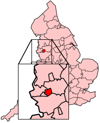
Borough of Warrington 
Status Unitary Authority, Borough Region North West England Zerem. Grafschaft Cheshire Trad. Grafschaft Cheshire, Lancashire Verwaltungssitz Warrington Fläche 180,64 km² (196.) Einwohner 195.200 (73.) ONS-Code 00EU Website www.warrington.gov.uk Das Borough of Warrington ist eine selbständige Verwaltungseinheit (Unitary Authority) im Nordwesten Englands, das zur Region North West England gehört. Der Verwaltungssitz befindet sich in der Stadt Warrington. Neben dem Gebiet des ehemaligen County Boroughs Warrington, welches keine eigenständige Gemeindeverwaltung besitzt, gibt es in der Unitary Authority 18 Gemeinden (civil parishes): Appleton, Birchwood, Burtonwood and Westbrook, Croft, Cuerdley, Culcheth and Glazebury, Grappenhall and Thelwall, Great Sankey, Hatton, Lymm, Penketh, Poulton-with-Fearnhead, Rixton-with-Glazebrook, Stockton Heath, Stretton, Walton, Winwick, Woolston.
Das Gebiet des Boroughs gehörte früher zur Grafschaft Lancashire. Im Zuge der Verwaltungsreform von 1974 wurde das Gebiet der Grafschaft Cheshire zugeordnet. Seit 1998 ist das Borough eine Unitary Authority und gehört nur noch zu zeremoniellen Anlässen zu Cheshire.
 Verwaltungsgrafschaften und Unitary Authorities in England
Grafschaften Englands mit zweistufiger Verwaltung (Non-Metropolitan Counties)
Buckinghamshire | Cambridgeshire | Cumbria | Derbyshire | Devon | Dorset | East Sussex | Essex | Gloucestershire | Hampshire | Hertfordshire | Kent | Lancashire | Leicestershire | Lincolnshire | Norfolk | Northamptonshire | North Yorkshire | Nottinghamshire | Oxfordshire | Somerset | Staffordshire | Suffolk | Surrey | Warwickshire | West Sussex | WorcestershireUnitary Authorities
Bath and North East Somerset | Bedford | Blackburn with Darwen | Blackpool | Bournemouth | Bracknell Forest | Brighton and Hove | Bristol | Central Bedfordshire | Cheshire East | Cheshire West and Chester | Cornwall | County Durham | Darlington | Derby | East Riding of Yorkshire | Halton | Hartlepool | Herefordshire | Isle of Wight | Isles of Scilly | Kingston upon Hull | Leicester | Luton | Medway | Middlesbrough | Milton Keynes | North East Lincolnshire | North Lincolnshire | North Somerset | Northumberland | Nottingham | Peterborough | Plymouth | Poole | Portsmouth | Reading | Redcar and Cleveland | Rutland | Shropshire | Slough | Southampton | Southend-on-Sea | South Gloucestershire | Stockton | Stoke-on-Trent | Swindon | Telford and Wrekin | Thurrock | Torbay | Warrington | West Berkshire | Wiltshire | Windsor and Maidenhead | Wokingham | York
Wikimedia Foundation.
Schlagen Sie auch in anderen Wörterbüchern nach:
Warrington Borough Transport — Volvo B7RLE bus at Warrington Interchange Slogan making warrington move Founded Warrington Corporation … Wikipedia
Warrington Town Hall — is in the town of Warrington, north Cheshire, England (gbmapping|SJ602883). It consists of a house, originally called Bank Hall, flanked by two detached service wings at right angles to the house, one on each side. The house and each service wing … Wikipedia
Warrington (Begriffsklärung) — Warrington ist der Name folgender Orte: in Großbritannien eine selbständige Gebietskörperschaft in England, siehe Warrington (Borough) eine Stadt im Borough of Warrington, siehe Warrington ein Ort in der Unitary Authority Milton Keynes in England … Deutsch Wikipedia
Warrington Bus Interchange — Warrington Interchange is a bus station in the town of Warrington, Cheshire in North West England. It opened in 2006 to replace a bus station built in 1979 alongside the Golden Square shopping centre. The new station is part of an extension and… … Wikipedia
Warrington — Infobox Settlement official name = The Borough of Warrington other name = native name = nickname = settlement type = Borough Unitary authority area (1998) motto = imagesize = 280px image caption = Warrington Town Hall flag size = image seal size … Wikipedia
Warrington Corporation Tramways — Infobox rail railroad name = Warrington Corporation Tramways system map caption = Diagram map of the Warrington tramway system locale = England start year = 1902 end year = 1935 successor line = Abandoned gauge = RailGauge|ussg length = 6.84… … Wikipedia
Warrington — 53.388888888889 2.5961111111111 Koordinaten: 53° 23′ N, 2° 36′ W … Deutsch Wikipedia
Warrington Rural District — infobox historic subdivision Name= Warrington Rural District HQ= Status= Rural district Start= 1894 End= 1974 Replace= Warrington AreaFirst= AreaLast= AreaFirstYear= AreaLastYear= PopulationFirst= PopulationLast= PopulationFirstYear=… … Wikipedia
Warrington Museum & Art Gallery — in a Grade II listed building [cite web | title=Listed buildings in Warrington | work=Warrington Borough Council | url=http://www.warrington.gov.uk/news/udp/interactive/interactive2/written/app8.asp | accessdate=2008 09 29] which it shares with… … Wikipedia
Warrington Central railway station — Infobox UK station name = Warrington Central code = WAC manager = TransPennine Express locale = Warrington borough = Warrington start = circa 1873 platforms = 2 usage0405 = 0.444 usage0506 = 0.399 usage0607 = 0.969 latitude = 53.3918 longitude =… … Wikipedia
Warrington (Borough)
18+
© Academic, 2000-2026
- Kontaktieren Sie uns: Unterstützung, Werbung
Wörterbücher Export, schritte mit PHP, Joomla, Drupal, WordPress, MODx.