- Bracknell Forest
-
Borough of Bracknell Forest 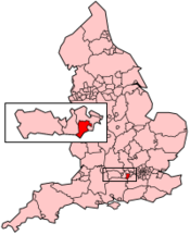
Basisdaten Status Unitary Authority, Borough Region South East England Zerem. Grafschaft Berkshire Verwaltungssitz Bracknell Fläche 109,38 km² (238.) Einwohner (2007) 113.500 (187.) ONS-Code 00MA Website www.bracknell-forest.gov.uk Bracknell Forest ist eine Unitary Authority und Borough in der Grafschaft Berkshire. Sie umfasst neben der Gartenstadt Bracknell mit dem Verwaltungssitz auch die umliegenden Dörfer Binfield, Crowthorne, Sandhurst, Warfield und Winkfield.
Die Gebietskörperschaft wurde am 1. April 1974 als District Bracknell gegründet. Im Mai 1988 erhielt es den Status einer Borough und der Name wurde in Bracknell Forest geändert. Als am 1. April 1988 der Grafschaftsrat von Berkshire aufgelöst wurde, wurde Bracknell Forest eine Unitary Authority.
Seit 1973 unterhielt Bracknell Forest eine Städtepartnerschaft mit der deutschen Stadt Opladen, die nach deren Eingemeindung von Leverkusen übernommen wurde.
Weblinks
 Verwaltungsgrafschaften und Unitary Authorities in England
Grafschaften Englands mit zweistufiger Verwaltung (Non-Metropolitan Counties)
Buckinghamshire | Cambridgeshire | Cumbria | Derbyshire | Devon | Dorset | East Sussex | Essex | Gloucestershire | Hampshire | Hertfordshire | Kent | Lancashire | Leicestershire | Lincolnshire | Norfolk | Northamptonshire | North Yorkshire | Nottinghamshire | Oxfordshire | Somerset | Staffordshire | Suffolk | Surrey | Warwickshire | West Sussex | WorcestershireUnitary Authorities
Bath and North East Somerset | Bedford | Blackburn with Darwen | Blackpool | Bournemouth | Bracknell Forest | Brighton and Hove | Bristol | Central Bedfordshire | Cheshire East | Cheshire West and Chester | Cornwall | County Durham | Darlington | Derby | East Riding of Yorkshire | Halton | Hartlepool | Herefordshire | Isle of Wight | Isles of Scilly | Kingston upon Hull | Leicester | Luton | Medway | Middlesbrough | Milton Keynes | North East Lincolnshire | North Lincolnshire | North Somerset | Northumberland | Nottingham | Peterborough | Plymouth | Poole | Portsmouth | Reading | Redcar and Cleveland | Rutland | Shropshire | Slough | Southampton | Southend-on-Sea | South Gloucestershire | Stockton | Stoke-on-Trent | Swindon | Telford and Wrekin | Thurrock | Torbay | Warrington | West Berkshire | Wiltshire | Windsor and Maidenhead | Wokingham | York
Wikimedia Foundation.
Schlagen Sie auch in anderen Wörterbüchern nach:
Bracknell Forest — is a unitary authority and borough in Berkshire in southern England. It covers the towns of Bracknell, North Ascot, Sandhurst, Crowthorne and surrounding villages and hamlets.HistoryBracknell Forest was formed on April 1 1974, as the non… … Wikipedia
Bracknell Forest local elections — Bracknell Forest Council is elected every four years.Political controlConservative 1997 presentCouncil electionsBracknell Forest Council election, 2000Bracknell Forest Council election, 2003Bracknell Forest Council election, 2007By election… … Wikipedia
Bracknell Forest — ▪ unitary authority, England, United Kingdom unitary authority, geographic and historic county of Berkshire, England. It is partly forested, has easy access to London, and is administered from the town of Bracknell. Old Bracknell town … Universalium
Lawrence Hill, Bracknell Forest — Infobox UK place country = England official name= Lawrence Hill latitude= 51.428890 longitude= 0.741146 map type= Berkshire population = population density = metropolitan borough= Bracknell Forest metropolitan county= Berkshire region= South East … Wikipedia
The Warren, Bracknell Forest — Infobox UK place country = England official name= The Warren latitude= 51.405168 longitude= 0.722480 map type= Berkshire population = population density = metropolitan borough= Bracknell Forest metropolitan county= Berkshire region= South East… … Wikipedia
Borough of Bracknell Forest — Admin ASC 2 Code Orig. name Borough of Bracknell Forest Country and Admin Code GB.ENG.B3 GB … World countries Adminstrative division ASC I-II
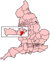
Bracknell (UK Parliament constituency) — Bracknell County constituency for the House of Commons Boundary of Bracknell in Berkshire … Wikipedia
Bracknell — Bracknell … Wikipédia en Français
Forest Park — can refer to any one of a number of places, many of them urban forests:Towns and villages*Forest Park, Bracknell Forest, Berkshire, UK *Forest Park, Georgia, USA *Forest Park, Illinois, USA *Forest Park, Ohio, USA, a city in Hamilton county… … Wikipedia
Bracknell (disambiguation) — Bracknell is a town in the Bracknell Forest borough of the English county of Berkshire.Bracknell may also refer to:* Bracknell, Tasmania, Australia * Bracknell (UK Parliament constituency), a county constituency represented in the House of… … Wikipedia
Bracknell Forest
18+
© Academic, 2000-2026
- Kontaktieren Sie uns: Unterstützung, Werbung
Wörterbücher Export, schritte mit PHP, Joomla, Drupal, WordPress, MODx.