- Wyandotte County
-
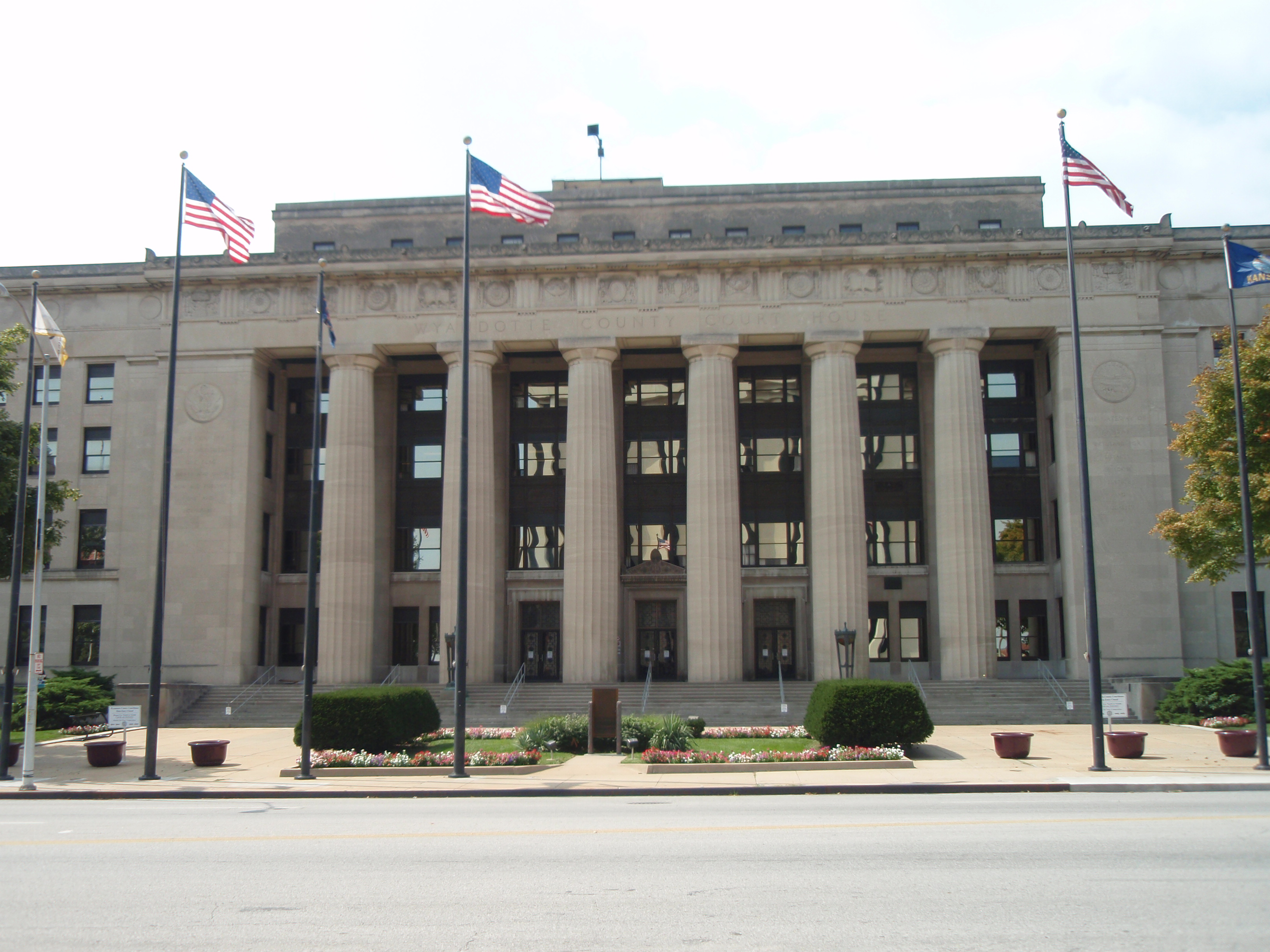
Verwaltung US-Bundesstaat: Kansas Verwaltungssitz: Kansas City Adresse des
Verwaltungssitzes:County Courthouse
701 N. 7th Street
Kansas City, KS 66101-3035Gründung: 1855 Gebildet aus: Original-County Vorwahl: 001 913 Demographie Einwohner: 157.505 (2010) Bevölkerungsdichte: 401,8 Einwohner/km² Geographie Fläche gesamt: 403 km² Wasserfläche: 11 km² Karte 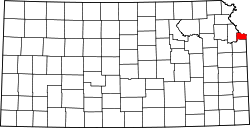
Website: www.wycokck.org Das Wyandotte County[2] ist ein County im US-amerikanischen Bundesstaat Kansas. Bei der Volkszählung im Jahr 2010 hatte das County 157.505 Einwohner und eine Bevölkerungsdichte von 401,8 Einwohnern pro Quadratkilometer. Der Verwaltungssitz (County Seat) ist Kansas City.[3]
Das Wyandotte County ist Bestandteil der Metropolregion Kansas City und besteht zum größten Teil aus der Stadt Kansas City, Kansas.
Inhaltsverzeichnis
Geografie
Das County liegt im Nordosten von Kansas, grenzt im Norden und Nordosten an Missouri, wobei die Grenze durch den Missouri River gebildet wird und hat eine Fläche von 403 Quadratkilometern, wovon 11 Quadratkilometer Wasserfläche sind. Es grenzt an folgende Countys:
Platte County
(Missouri)Clay County
(Missouri)Leavenworth County 
Jackson County
(Missouri)Johnson County Geschichte
Das Wyandotte County wurde 1855 als Original-County aus Teilen des Kansas - Territoriums gebildet und gehört zu den ersten 33 Countys, die von der ersten Territorial-Verwaltung gebildet wurden. Benannt wurde es nach dem Indianervolk der Wyandot(te).
Demografische Daten
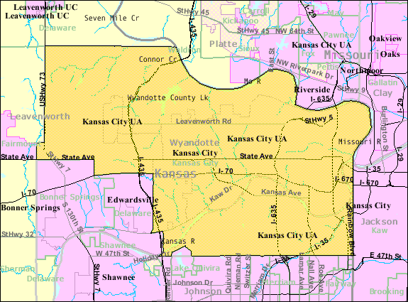
Historische Einwohnerzahlen Census Einwohner ± in % 1860 2609 — 1870 10.015 300 % 1880 19.143 90 % 1890 54.407 200 % 1900 73.227 30 % 1910 100.068 40 % 1920 122.218 20 % 1930 141.211 20 % 1940 145.071 3 % 1950 165.318 10 % 1960 185.495 10 % 1970 186.845 0,7 % 1980 172.335 -8 % 1990 161.993 -6 % 2000 157.882 -3 % 2010 157.505 -0,2 % Vor 1900[4] 1900–1990[5] 2010[6]  Karte des Wyandotte County
Nach der Volkszählung im Jahr 2010 lebten im Wyandotte County 157.505 Menschen in 58.640 Haushalten. Die Bevölkerungsdichte betrug 401,8 Einwohner pro Quadratkilometer.
Ethnisch betrachtet setzte sich die Bevölkerung zusammen aus 54,6 Prozent Weißen, 25,2 Prozent Afroamerikanern, 0,8 Prozent amerikanischen Ureinwohnern, 2,5 Prozent Asiaten sowie aus anderen ethnischen Gruppen; 3,7 Prozent stammten von zwei oder mehr Ethnien ab. Unabhängig von der ethnischen Zugehörigkeit waren 26,4 Prozent der Bevölkerung spanischer oder lateinamerikanischer Abstammung.
In den 58.640 Haushalten lebten statistisch je 2,59 Personen.
28,0 Prozent der Bevölkerung waren unter 18 Jahre alt, 61,4 Prozent waren zwischen 18 und 64 und 10,6 Prozent waren 65 Jahre oder älter. 51,0 Prozent der Bevölkerung war weiblich.
Das jährliche Durchschnittseinkommen eines Haushalts lag bei 37.341 USD. Das Pro - Kopf - Einkommen betrug 18.849 USD. 21,4 Prozent der Einwohner lebten unterhalb der Armutsgrenze.[7]
Städte und Gemeinden
- Bonner Springs1
- Edwardsville
- Kansas City
- Lake Quivira2
- Turner
1 - teilweise im Johnson und im Leavenworth County
2 - teilweise im Johnson CountyEinzelnachweise
- ↑ Auszug aus dem National Register of Historic Places. Abgerufen am 13. März 2011
- ↑ GNIS-ID: 485065. Abgerufen am 22. Februar 2011 (englisch).
- ↑ National Association of Counties Abgerufen am 15. Oktober 2011
- ↑ U.S. Census Bureau - Census of Population and Housing Abgerufen am 15. März 2011
- ↑ Auszug aus Census.gov Abgerufen am 17. Februar 2011
- ↑ United States Census 2010 Abgerufen am 15. Oktober 2011
- ↑ U.S. Census Buero, State & County QuickFacts - Wyandotte County Abgerufen am 15. Oktober 2011
Weblinks
-
 Commons: Wyandotte County, Kansas – Sammlung von Bildern, Videos und Audiodateien
 - Offizielle Webseite
- U.S. Census Buero, State & County QuickFacts - Wyandotte County
- Yahoo Bildersuche - Wyandotte County
- www.city-data.com - Wyandotte County

Liste der Countys in Kansas
Allen | Anderson | Atchison | Barber | Barton | Bourbon | Brown | Butler | Chase | Chautauqua | Cherokee | Cheyenne | Clark | Clay | Cloud | Coffey | Comanche | Cowley | Crawford | Decatur | Dickinson | Doniphan | Douglas | Edwards | Elk | Ellis | Ellsworth | Finney | Ford | Franklin | Geary | Gove | Graham | Grant | Gray | Greeley | Greenwood | Hamilton | Harper | Harvey | Haskell | Hodgeman | Jackson | Jefferson | Jewell | Johnson | Kearny | Kingman | Kiowa | Labette | Lane | Leavenworth | Lincoln | Linn | Logan | Lyon | Marion | Marshall | McPherson | Meade | Miami | Mitchell | Montgomery | Morris | Morton | Nemaha | Neosho | Ness | Norton | Osage | Osborne | Ottawa | Pawnee | Phillips | Pottawatomie | Pratt | Rawlins | Reno | Republic | Rice | Riley | Rooks | Rush | Russell | Saline | Scott | Sedgwick | Seward | Shawnee | Sheridan | Sherman | Smith | Stafford | Stanton | Stevens | Sumner | Thomas | Trego | Wabaunsee | Wallace | Washington | Wichita | Wilson | Woodson | Wyandotte
Wikimedia Foundation.
Schlagen Sie auch in anderen Wörterbüchern nach:
Wyandotte County — Admin ASC 2 Code Orig. name Wyandotte County Country and Admin Code US.KS.209 US … World countries Adminstrative division ASC I-II
Wyandotte County, Kansas — Infobox U.S. County county=Wyandotte County state=Kansas founded= 1859 seat wl=Kansas City area total km2=403|area total sq mi=156 area land km2=392|area land sq mi=151 area water km2=11|area water sq mi=4 area percentage=2.76% census estimate yr … Wikipedia
National Register of Historic Places listings in Wyandotte County, Kansas — Location of Wyandotte County in Kansas This is a list of the National Register of Historic Places listings in Wyandotte County, Kansas. This is intended to be a complete list of the properties and districts on the National Register of Historic… … Wikipedia
List of Wyandotte County parks and parkways — Below is a list of Wyandotte County parks and parkways. This includes the various open spaces and senenic areas, such as parks and parkways, in Wyandotte County, Kansas, United States, which includes the cities of Kansas City, Bonner Springs, and … Wikipedia
Wyandotte, Michigan — City Location in … Wikipedia
Wyandotte (Michigan) — Wyandotte Lage im County und in Michigan … Deutsch Wikipedia
Wyandotte — is an alternate spelling of Wyandot, a group of native North Americans also known as the Hurons. Wyandotte may also refer to:* Wyandotte , a novel by James Fenimore Cooper *Wyandotte, Michigan *Wyandotte, Oklahoma *Wyandotte County, Kansas… … Wikipedia
County statistics of the United States — The counties are used in 48 of the 50 states of the United States for the level of local government below the state itself. Louisiana uses parishes, and Alaska uses boroughs. In several states in New England, some or all counties within states… … Wikipedia
County seat war — A county seat war is a phenomenon that occurred in the American West as it was being settled, although incidences elsewhere, such as in West Virginia, have been also been recorded. As new towns sprang up and county lines were drawn, there was… … Wikipedia
Wyandotte Caves — Wyandotte Caves, a pair of limestone caves located on the Ohio River in Harrison Crawford State Forest in Crawford County, five miles (8 km) north east of Leavenworth and 12 miles (19 km) from Corydon in southern Indiana, is a popular tourist… … Wikipedia
Wyandotte County


18+
© Academic, 2000-2024
- Kontaktieren Sie uns: Unterstützung, Werbung
Wörterbücher Export, schritte mit PHP, Joomla, Drupal, WordPress, MODx.