- Johnson County (Kansas)
-
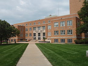 Das Johnson County Courthouse in Olathe
Verwaltung US-Bundesstaat: Kansas Verwaltungssitz: Olathe Adresse des
Verwaltungssitzes:County Courthouse
111 South Cherry
Olathe, KS 66061-3421Gründung: 1855 Gebildet aus: Original-County Vorwahl: 001 913 Demographie Einwohner: 451.086 (2000) Bevölkerungsdichte: 365,3 Einwohner/km² Geographie Fläche gesamt: 1.244 km² Wasserfläche: 9 km² Karte 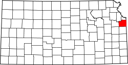
Website: www.jocogov.org Das Johnson County[1] ist ein County im US-amerikanischen Bundesstaat Kansas. Bei der Volkszählung im Jahr 2010 hatte das County 544.179 Einwohner und eine Bevölkerungsdichte von 365,3 Einwohnern pro Quadratkilometer. Der Verwaltungssitz (County Seat) ist Olathe.[2]
Das Johnson County ist Bestandteil der Metropolregion Kansas City.
Inhaltsverzeichnis
Geografie
Das County liegt im Osten von Kansas, grenzt an Missouri und hat eine Fläche von 1.244 Quadratkilometern, wovon 9 Quadratkilometer Wasserfläche sind. Es grenzt an folgende Countys:
Leavenworth County Wyandotte County Douglas County 
Jackson County
(Missouri)Franklin County Miami County Cass County
(Missouri)Geschichte
Das Johnson County wurde 1855 als Original-County aus als frei bezeichneten - in Wirklichkeit aber von Indianern besiedelten - Gebiet des Kansas-Territoriums gebildet und gehört zu den ersten 33 Countys, die von der ersten Territorial-Verwaltung gebildet wurden. Benannt wurde es nach Reverend Thomas Johnson (1802-1865), einem methodistischen Missionar und Mitglied der Verwaltung des Kansas-Territoriums, der im Amerikanischen Bürgerkrieg von Partisanen der Konföderierten getötet wurde.
Ein Zweig des Santa Fe Trails verläuft durch das County, 1858 siedelte hier Wild Bill&nbs;Hickok für einige Zeit.
Demografische Daten
Historische Einwohnerzahlen Census Einwohner ± in % 1860 4364 — 1870 13.648 200 % 1880 16.853 20 % 1890 17.385 3 % 1900 18.104 4 % 1910 18.288 1 % 1920 18.314 0,1 % 1930 21.179 20 % 1940 33.327 60 % 1950 62.783 90 % 1960 143.792 100 % 1970 220.073 50 % 1980 270.269 20 % 1990 357.048 30 % 2000 451.086 30 % 2010 544.179 20 % vor 1900[3] 1900–1990[4] 2010[5] Nach der Volkszählung im Jahr 2010 lebten im Johnson County 544.179 Menschen in 201.911 Haushalten. Die Bevölkerungsdichte betrug 365,3 Einwohner pro Quadratkilometer.
Ethnisch betrachtet setzte sich die Bevölkerung zusammen aus 86,0 Prozent Weißen, 4,3 Prozent Afroamerikanern, 0,4 Prozent amerikanischen Ureinwohnern, 4,2 Prozent Asiaten sowie aus anderen ethnischen Gruppen; 2,5nbsp;Prozent stammten von zwei oder mehr Ethnien ab. Unabhängig von der ethnischen Zugehörigkeit waren 7,2 Prozent der Bevölkerung spanischer oder lateinamerikanischer Abstammung.
In den 201.911 Haushalten lebten statistisch je 2,58 Personen.
25,4 Prozent der Bevölkerung waren unter 18 Jahre alt, 63,9 Prozent waren zwischen 18 und 64 und 10,7 Prozent waren 65 Jahre oder älter. 50,6 Prozent der Bevölkerung war weiblich.
Das jährliche Durchschnittseinkommen eines Haushalts lag bei 72.006 USD. Das Pro - Kopf - Einkommen betrug 37.118 USD. 6,8 Prozent der Einwohner lebten unterhalb der Armutsgrenze.[6]
Städte und Gemeinden
- Bonner Springs1
- De Soto 2
- Edgerton
- Fairway
- Gardner
- Lake Quivira3
- Leawood
- Lenexa
- Merriam
- Mission
- Mission Hills
- Mission Woods
- Olathe
- Overland Park
- Prairie Village
- Roeland Park
- Shawnee
- Spring Hill4
- Westwood
- Westwood Hills
- Stilwell
1 - teilweise im Leavenworth und im Wyandotte County
2 - teilweise im Leavenworth County
3 - teilweise im Wyandotte County
4 - teilweise im Miami CountyEinzelnachweise
- ↑ GNIS-ID: 485010. Abgerufen am 22. Februar 2011 (englisch).
- ↑ National Association of Counties Abgerufen am 12. Oktober 2011
- ↑ U.S. Census Bureau - Census of Population and Housing Abgerufen am 15. März 2011
- ↑ Auszug aus Census.gov Abgerufen am 17. Februar 2011
- ↑ United States Census 2010 Abgerufen am 12. Oktober 2011
- ↑ U.S. Census Buero, State & County QuickFacts - Johnson County Abgerufen am 11. Oktober 2011
Weblinks
-
 Commons: Johnson County, Kansas – Sammlung von Bildern, Videos und Audiodateien
 - Offizielle Webseite
- U.S. Census Buero, State & County QuickFacts - Johnson County
- Yahoo Bildersuche - Johnson County
- www.city-data.com - Johnson County
- Homepage Kansas Government

Liste der Countys in Kansas
Allen | Anderson | Atchison | Barber | Barton | Bourbon | Brown | Butler | Chase | Chautauqua | Cherokee | Cheyenne | Clark | Clay | Cloud | Coffey | Comanche | Cowley | Crawford | Decatur | Dickinson | Doniphan | Douglas | Edwards | Elk | Ellis | Ellsworth | Finney | Ford | Franklin | Geary | Gove | Graham | Grant | Gray | Greeley | Greenwood | Hamilton | Harper | Harvey | Haskell | Hodgeman | Jackson | Jefferson | Jewell | Johnson | Kearny | Kingman | Kiowa | Labette | Lane | Leavenworth | Lincoln | Linn | Logan | Lyon | Marion | Marshall | McPherson | Meade | Miami | Mitchell | Montgomery | Morris | Morton | Nemaha | Neosho | Ness | Norton | Osage | Osborne | Ottawa | Pawnee | Phillips | Pottawatomie | Pratt | Rawlins | Reno | Republic | Rice | Riley | Rooks | Rush | Russell | Saline | Scott | Sedgwick | Seward | Shawnee | Sheridan | Sherman | Smith | Stafford | Stanton | Stevens | Sumner | Thomas | Trego | Wabaunsee | Wallace | Washington | Wichita | Wilson | Woodson | Wyandotte
Wikimedia Foundation.
Schlagen Sie auch in anderen Wörterbüchern nach:
Johnson County, Kansas — Johnson Courthouse in Olathe … Wikipedia
Johnson County, Kansas Sheriff’s Office — The Johnson County Sheriff s Office, headquartered in Olathe, Kansas, was established in 1861 and has grown from a one man office to a highly skilled and advanced law enforcement agency.The Johnson County Sheriff s Office is the fastest growing… … Wikipedia
National Register of Historic Places listings in Johnson County, Kansas — Location of Johnson County in Kansas This is a list of the National Register of Historic Places listings in Johnson County, Kansas. This is intended to be a complete list of the properties and districts on the National Register of Historic Places … Wikipedia
Monticello Township, Johnson County, Kansas — Monticello Township is a former township in northwest Johnson County, Kansas. It is now merged with Lenexa and Shawnee, Kansas. Contents 1 History 2 Notable residents 3 See also 4 … Wikipedia
Aubry Township, Johnson County, Kansas — Infobox Settlement official name = Aubry Township settlement type = Township nickname = motto = imagesize = image caption = image imagesize = image caption = image mapsize = map caption = Location in Johnson County mapsize1 = map caption1 =… … Wikipedia
Johnson County Community College — (often referred to as JCCC) is located in Overland Park, Kansas. In 1963, Johnson County Commissioners recognized the great demand in the area for a community college, and to accommodate the rapidy growing population of Johnson County, Kansas. In … Wikipedia
Johnson County — is the name of several counties in the United States: Johnson County, Arkansas Johnson County, Georgia Johnson County, Illinois Johnson County, Indiana Johnson County, Iowa Johnson County, Kansas Johnson County, Kentucky Johnson County, Missouri… … Wikipedia
Johnson County Transit — Infobox Bus transit name = Johnson County Transit The JO logo size = 150px image size = 150px image caption = company slogan = parent = founded = 1982 headquarters = Olathe, Kansas locale = Johnson County, Kansas Kansas City Metropolitan Area… … Wikipedia
Johnson County Executive Airport — Infobox Airport name = Johnson County Executive Airport nativename = nativename a = nativename r = image width = caption = IATA = OJC ICAO = KOJC FAA = OJC type = Public owner = operator = Johnson County Airport Commission city served = location … Wikipedia
Johnson County — Es gibt in den Vereinigten Staaten zwölf Countys mit dem Namen Johnson County: Johnson County (Arkansas) Johnson County (Georgia) Johnson County (Illinois) Johnson County (Indiana) Johnson County (Iowa) Johnson County (Kansas) Johnson County… … Deutsch Wikipedia
Johnson County (Kansas)


18+
© Academic, 2000-2026
- Kontaktieren Sie uns: Unterstützung, Werbung
Wörterbücher Export, schritte mit PHP, Joomla, Drupal, WordPress, MODx.