- Marshall County (Kansas)
-
Verwaltung US-Bundesstaat: Kansas Verwaltungssitz: Marysville Adresse des
Verwaltungssitzes:County Courthouse
1201 Broadway
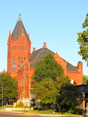
Marysville, KS 66508-1844Gründung: 25. August 1855 Vorwahl: 001 785 Demographie Einwohner: 10.965 (2000) Bevölkerungsdichte: 4,7 Einwohner/km² Geographie Fläche gesamt: 2.342 km² Wasserfläche: 5 km² Karte Website: www.marshall.kansasgov.com Marshall County[2] ist ein County im Bundesstaat Kansas der Vereinigten Staaten von Amerika. Bei der Volkszählung im Jahr 2000 hatte das County 10.965 Einwohner und eine Bevölkerungsdichte von 5 Einwohnern pro Quadratkilometer. Der Verwaltungssitz (County Seat) ist Marysville.
Inhaltsverzeichnis
Geografie
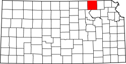
Das County liegt im Nordosten von Kansas, grenzt im Norden an Nebraska und hat eine Fläche von 2342 Quadratkilometern, wovon 5 Quadratkilometer Wasserfläche sind. Es grenzt in Kansas im Uhrzeigersinn an folgende Countys: Nemaha County, Pottawatomie County, Riley County und Washington County.
Geschichte
Marshall County wurde am 25. August 1855 gebildet und gehört zu den ersten 33 Countys, die von der ersten Territorial-Verwaltung gebildet wurden. Benannt wurde es nach Frank J. Marshall, einem US-General, der eine Fähre zur Überquerung des Big Blue River erbaute. Am 30. Mai 1879 zog der Tornado Irving durch das County. Er erreichte die Stärke F4 auf der Fujita-Skala, was eine Windgeschwindigkeit von 333–419 km/h bedeutet, und hinterließ einen Pfad der Verwüstung von rund 700 m Breite und 160 km Länge. Dabei starben 18 Menschen und 60 wurden verletzt.
Demografische Daten
Historische Einwohnerzahlen Census Einwohner ± in % 1860 2280 — 1870 6901 200 % 1880 16.126 100 % 1890 23.912 50 % 1900 24.355 2 % 1910 23.880 -2 % 1920 22.730 -5 % 1930 23.056 1 % 1940 20.986 -9 % 1950 17.926 -10 % 1960 15.598 -10 % 1970 13.139 -20 % 1980 12.787 -3 % 1990 11.705 -8 % 2000 10.965 -6 % Vor 1900[3] 1900–1990[4]
Nach der Volkszählung im Jahr 2000 lebten im Marshall County 10.965 Menschen. Davon wohnten 244 Personen in Sammelunterkünften, die anderen Einwohner lebten in 4458 Haushalten und 3026 Familien. Die Bevölkerungsdichte betrug 5 Einwohner pro Quadratkilometer. Ethnisch betrachtet setzte sich die Bevölkerung zusammen aus 98,14 Prozent Weißen, 0,23 Prozent Afroamerikanern, 0,36 Prozent amerikanischen Ureinwohnern, 0,19 Prozent Asiaten, 0,02 Prozent Bewohnern aus dem pazifischen Inselraum und 0,26 Prozent aus anderen ethnischen Gruppen; 0,80 Prozent stammten von zwei oder mehr Ethnien ab. 0,76 Prozent der Bevölkerung waren spanischer oder lateinamerikanischer Abstammung.
Von den 4458 Haushalten hatten 30,2 Prozent Kinder unter 18 Jahren, die mit ihnen gemeinsam lebten. 59,7 Prozent waren verheiratete, zusammenlebende Paare, 5,4 Prozent waren allein erziehende Mütter und 32,1 Prozent waren keine Familien. 29,5 Prozent aller Haushalte waren Singlehaushalte und in 17,0 Prozent lebten Menschen mit 65 Jahren oder darüber. Die Durchschnittshaushaltsgröße betrug 2,40 und die durchschnittliche Familiengröße betrug 2,98 Personen.
25,0 Prozent der Bevölkerung waren unter 18 Jahre alt. 6,6 Prozent zwischen 18 und 24 Jahre, 23,6 Prozent zwischen 25 und 44 Jahre, 22,8 Prozent zwischen 45 und 64 Jahre und 22,0 Prozent waren 65 Jahre alt oder älter. Das Durchschnittsalter betrug 42 Jahre. Auf 100 weibliche Personen kamen 96,8 männliche Personen. Auf 100 erwachsene Frauen ab 18 Jahren kamen 94,0 Männer.
Das jährliche Durchschnittseinkommen eines Haushalts betrug 32.089 USD, das Durchschnittseinkommen einer Familie betrug 39.705 USD. Männer hatten ein Durchschnittseinkommen von 28.361 USD, Frauen 19.006 USD. Das Prokopfeinkommen betrug 17.090 USD. 6,4 Prozent der Familien und 9,2 Prozent der Bevölkerung lebten unterhalb der Armutsgrenze.[5]
Städte und Gemeinden
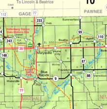
Im Marshall County gibt es neun Gemeinden, die alle – wie in ganz Kansas – Cities genannt werden.
Name Gesamtfläche Einwohner km² Stand: 2000 Axtell 1,3 445 Beattie 0,6 277 Blue Rapids 5,4 1.088 Frankfort 2,6 855 Marysville 8,5 3.271 Oketo 0,3 87 Summerfield 0,9 211 Vermillion 0,7 107 Waterville 1,3 681 Unincorporated Area 2.320,4 3.943 Siehe auch
Einzelnachweise
- ↑ Auszug aus dem National Register of Historic Places. Abgerufen am 13. März 2011
- ↑ GNIS-ID: 485023. Abgerufen am 22. Februar 2011 (englisch).
- ↑ U.S. Census Bureau - Census of Population and Housing. Abgerufen am 15. März 2011
- ↑ Auszug aus Census.gov. Abgerufen am 17. Februar 2011
- ↑ Marshall County, Kansas, Datenblatt mit den Ergebnissen der Volkszählung im Jahre 2000 bei factfinder.census.gov.
Weblinks
- Homepage Kansas Government (engl.)
Liste der Countys in Kansas
Allen | Anderson | Atchison | Barber | Barton | Bourbon | Brown | Butler | Chase | Chautauqua | Cherokee | Cheyenne | Clark | Clay | Cloud | Coffey | Comanche | Cowley | Crawford | Decatur | Dickinson | Doniphan | Douglas | Edwards | Elk | Ellis | Ellsworth | Finney | Ford | Franklin | Geary | Gove | Graham | Grant | Gray | Greeley | Greenwood | Hamilton | Harper | Harvey | Haskell | Hodgeman | Jackson | Jefferson | Jewell | Johnson | Kearny | Kingman | Kiowa | Labette | Lane | Leavenworth | Lincoln | Linn | Logan | Lyon | Marion | Marshall | McPherson | Meade | Miami | Mitchell | Montgomery | Morris | Morton | Nemaha | Neosho | Ness | Norton | Osage | Osborne | Ottawa | Pawnee | Phillips | Pottawatomie | Pratt | Rawlins | Reno | Republic | Rice | Riley | Rooks | Rush | Russell | Saline | Scott | Sedgwick | Seward | Shawnee | Sheridan | Sherman | Smith | Stafford | Stanton | Stevens | Sumner | Thomas | Trego | Wabaunsee | Wallace | Washington | Wichita | Wilson | Woodson | Wyandotte
Wikimedia Foundation.
Schlagen Sie auch in anderen Wörterbüchern nach:
Marshall County, Kansas — Marshall County Courthouse … Wikipedia
National Register of Historic Places listings in Marshall County, Kansas — Location of Marshall County in Kansas This is a list of the National Register of Historic Places listings in Marshall County, Kansas. This is intended to be a complete list of the properties and districts on the National Register of Historic… … Wikipedia
Rock Township, Marshall County, Kansas — Infobox Settlement official name = Rock Township, Marshall County, Kansas settlement type = Township nickname = motto = imagesize = image caption = image |pushpin pushpin label position =left pushpin map caption =Location within the state of… … Wikipedia
Marshall County Courthouse — or Marshall County Court House may refer to: Marshall County Courthouse (Indiana), Plymouth, Indiana, listed on the NRHP in Marshall County, Indiana Marshall County Courthouse (Iowa), Marshalltown, Iowa, NRHP listed Marshall County Courthouse… … Wikipedia
Marshall County (disambiguation) — Marshall County is the name of twelve counties in the United States:* Marshall County, Alabama * Marshall County, Illinois * Marshall County, Indiana * Marshall County, Iowa * Marshall County, Kansas * Marshall County, Kentucky * Marshall County … Wikipedia
Marshall County — is the name of twelve counties in the United States: Marshall County, Alabama Marshall County, Illinois Marshall County, Indiana Marshall County, Iowa Marshall County, Kansas Marshall County, Kentucky Marshall County, Minnesota Marshall County,… … Wikipedia
Marshall County — Es gibt in den Vereinigten Staaten zwölf Countys mit dem Namen Marshall County: Marshall County (Alabama) Marshall County (Illinois) Marshall County (Indiana) Marshall County (Iowa) Marshall County (Kansas) Marshall County (Kentucky) Marshall… … Deutsch Wikipedia
Marshall County, Indiana — Marshal County courthouse in Plymouth, Indiana … Wikipedia
Marshall County Courthouse (Iowa) — Marshall County Courthouse U.S. National Register of Historic Places … Wikipedia
Marshall County Courthouse — bezeichnet mehrere gleichnamige, im NRHP gelistete, Objekte: Marshall County Courthouse (Iowa), ID Nr. 72000478 Marshall County Courthouse (Kansas), ID Nr. 74000843 Marshall County Courthouse (Oklahoma), ID Nr. 84003154 Marshall County Courthouse … Deutsch Wikipedia


