Bexleyheath

Bexleyheath
London Borough of Bexley
Bexley
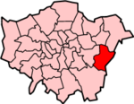
Lage in Greater London
Status London Borough
Region Greater London
Verwaltungssitz Bexleyheath
Fläche 60,56 km² (289.)
Einwohner (2007) 220.100 (56.)
ONS-Code 00AD
Website www.bexley.gov.uk

London Borough of Bexley [ˈbɛksli] ist ein Stadtbezirk von London und liegt im Osten der Stadt. Bei der Gründung von Greater London im Jahr 1965 wurde er aus folgenden Gemeinden der Grafschaft Kent gebildet: Bexley, Crayford, Erith sowie etwa die Hälfte von Chislehurst and Sidcup.

Partnerstädte sind Arnsberg und Évry. Die Bevölkerung setzt sich aus 91,4 % Weißen, 3,4 % Südasiaten und 2,9 % Schwarzen zusammen.

Stadtteile

  • Albany Park
  • Barnehurst
  • Barnes Cray
  • Belvedere
  • Bexley
  • Bexleyheath
  • Blackfen
  • Blendon
  • Bostall
  • Bridgen
  • Coldblow
  • Crayford
  • Crook Log
  • East Wickham
  • Erith
  • Falconwood
  • Foots Cray
  • Lamorbey
  • Lessness Heath
  • Longlands
  • May Place
  • North Cray
  • North End
  • Northumberland Heath
  • Old Bexley
  • Sidcup
  • Slade Green
  • Thamesmead
  • Upper Belvedere
  • Upton
  • Welling
  • West Heath

Persönlichkeiten

Weblinks


Wikimedia Foundation.

Игры ⚽ Поможем написать курсовую

Schlagen Sie auch in anderen Wörterbüchern nach:

  • Bexleyheath — infobox UK place country = England map type = Greater London region= London population= official name= Bexleyheath latitude= 51.4589 longitude= 0.1384 os grid reference= TQ485755 london borough= Bexley post town= BEXLEYHEATH postcode area=DA… …   Wikipedia

  • Bexleyheath — Original name in latin Bexleyheath Name in other language State code GB Continent/City Europe/London longitude 51.46291 latitude 0.13943 altitude 52 Population 0 Date 2011 02 12 …   Cities with a population over 1000 database

  • Bexleyheath School — was once an all girls secondary modern school on one site and a boys school on the Graham Road site. The two combined to become Bexleyheath School. Located in Bexleyheath, it has been around since before World War II. Today, Bexleyheath School is …   Wikipedia

  • Bexleyheath Line — The Bexleyheath Line is last of the three rail routes created between the outskirts of London and Dartford in Kent.HistoryConstructionThe Bexleyheath Line leaves the North Kent Line immediately on the Down side of Blackheath railway station and… …   Wikipedia

  • Bexleyheath railway station — Infobox London station name = Bexleyheath manager = Southeastern zone = 5 locale = Bexleyheath borough = Bexley platforms= ? railcode=BXH railexits0405 = 2.241 railexits0506 = 2.260 railexits0607 = 2.989 start = 1 May 1895Bexleyheath railway… …   Wikipedia

  • Bexleyheath and Crayford (UK Parliament constituency) — UK constituency infobox alt Name = Bexleyheath and Crayford Type = Borough Entity = Greater London DivisionType = County Division = Greater London Year = 1997 MP = David Evennett Party = Conservative EP = LondonBexleyheath and Crayford is a… …   Wikipedia

  • Bexleyheath (UK Parliament constituency) — UK former constituency infobox Name = Bexleyheath Type = Borough Year = 1974 Abolition = 1997 members = oneBexleyheath was a parliamentary constituency in the London Borough of Bexley, outer London, which returned one Member of Parliament to the… …   Wikipedia

  • List of churches in London — St. Paul s from the South London is the location of many famous churches, chapels and cathedrals, in a density unmatched anywhere else in England.[1] …   Wikipedia

  • List of night buses in London — Night buses in London are after hours versions of their daytime numerical equivalents, normally running the same route but with extensions at either end of the service. This is normally to provide a night service to destinations served by tube or …   Wikipedia

  • London Buses route 492 — Infobox London Bus number=492 operator=Arriva Southern Counties length= 14 miles (22 km) time= 52 87 minutes garage=Dartford start=Bluewater end=Sidcup via=Dartford Crayford Bexleyheath Bexley level=Daily frequency=About every 30 minutes night=… …   Wikipedia

Share the article and excerpts

Direct link
Do a right-click on the link above
and select “Copy Link”