Boyce Thompson Arboretum State Park
- Boyce Thompson Arboretum State Park
-
Der Boyce Thompson Arboretum State Park enthält den größten und ältesten botanischen Garten von Arizona.
Das Arboretum wurde in den 1920er Jahren vom Bergwerksunternehmer William Boyce Thompson gegründet. Thompson war zuvor mit dem Amerikanischen Roten Kreuz in Russland gewesen und hatte dort die große Bedeutung von Pflanzen als Rohstoff für menschliche Nahrung, Bekleidung und Baumaterial erkannt. Er beschloss, sein Vermögen zur Optimierung der Nutzung pflanzlicher Rohstoffe einzusetzen; das Arboretum hinterließ er als Teil seines Vermächtnisses. Seit 1976 kümmern sich das Arizona State Parks Board, das Boyce Thompson Arboretum Board und die University of Arizona um die Verwaltung. Das 131 ha große Gelände liegt am U.S. Highway 60, 4 km östlich von Superior im Pinal County des US-Bundesstaates Arizona.[1]
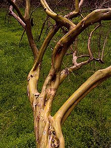
2008 waren im Park 23 bezahlte Voll- und Teilzeitkräfte beschäftigt. Die jährlichen Besucherzahlen schwanken zwischen 65.000 und 75.000. Der Park ist in verschiedene Bereiche aufgeteilt, in denen sich Pflanzensammlungen aus Australien, Afrika, Asien, dem Mittelmeerraum sowie aus Nord- und Südamerika befinden. Im Arboretum wachsen 3.100 Pflanzenarten mit 14.000 Pflanzenindividuen, darunter 567 Kakteengewächse, 299 Hülsenfrüchtler, 179 Schwertliliengewächse, 176 Liliengewächse, 161 Myrtengewächse, 157 Agavengewächse, 131 Korbblütler, 104 Lippenblütler, 86 Rosengewächse und 47 Palmengewächse. In der Australienabteilung befindet sich ein besonderes Exemplar des Roten Eukalyptus (Eucalyptus camaldulensis). Er wurde bereits 1926 gepflanzt und ist mit einer Höhe von über 42 m der größte seiner Art in den Vereinigten Staaten.[2]
Einzelnachweise
- ↑ http://azstateparks.com/Parks/BOTH/index.html
- ↑ http://azstateparks.com/Parks/BOTH/rules.html
Weblinks
Siehe auch
33.278619-111.157072750
Kategorien: - State Park in Arizona
- Arboretum in den Vereinigten Staaten
Wikimedia Foundation.
Schlagen Sie auch in anderen Wörterbüchern nach:
Boyce Thompson Arboretum State Park — is an Arizona state park located in Superior, Arizona near Phoenix, Arizona in the United States. It consists of a convert|323|acre|km2|sing=on botanical collection that includes a wide range of habitats and a 1.5 mile (2.4 km) main loop walking… … Wikipedia
Bayard Cutting Arboretum State Park — Standard fauna of Bayard Cutting Arboretum. Bayard Cutting Arboretum State Park is located in the hamlet of Great River, Suffolk County, New York, USA. The extensively landscaped garden is in the nature of an estate arboretum, laid out, starting… … Wikipedia
Dead Horse Ranch State Park — Coordinates: 34°45′8″N 112°0′44″W / 34.75222°N 112.01222°W / 34.75222; 112.01222 … Wikipedia
State Parks in Arizona — Dead Horse Ranch State Park Jerome State Historic Park … Deutsch Wikipedia
Oracle State Park — Coordinates: 32°35′28″N 110°34′43″W / 32.59111°N 110.57861°W / 32.59111; 110.57861 … Wikipedia
Franklin D. Roosevelt State Park — For other places with the same name, see FDR State Park (disambiguation). Franklin D. Roosevelt State Park is a state park in Westchester County, New York. It was formerly known as Mohansic Park and Mohansic State Park and is situated in Yorktown … Wikipedia
Margaret Lewis Norrie State Park — is a state park in Dutchess County, New York in the USA. The park is located on the east shore of the Hudson River in the Town of Hyde Park. Within the state park is the Staatsburgh State Historic Site, informally called Mills Mansion, a 65 room… … Wikipedia
Cold Spring Harbor State Park — has 40 acres (160,000 m2) of hilly land, offering scenic views of Cold Spring Harbor, New York, USA on the north shore of Long Island. This state park is in the Town of Huntington in Suffolk County. The park offers hiking, birdwatching,… … Wikipedia
Max V. Shaul State Park — s entrance Max V. Shaul State Park is a small state park in Schoharie County, New York, USA. The park is located on Route 30 in the Town of Fulton. Originally named Toepath Mountain Picnic Area and Campsite, it opened on May 28, 1959.[1] … Wikipedia
Donald J. Trump State Park — Entrance sign to Donald J. Trump State Park Donald J. Trump State Park is a 436 acre (1.8 km2) state park located within the towns of Yorktown and Putnam Valley in Westchester County and Putnam County, New York. The park is currently under… … Wikipedia

